How the Data Finder Works
Information presented in the Data Finder come directly from the World Water
and Climate Atlas, a project of the International
Water Management Institute (IWMI)![]() .
EPA would like to thank IWMI for the use of this data.
.
EPA would like to thank IWMI for the use of this data.
IWMI's model relies on historic information collected from thousands
of global weather stations from 1961-1990. For information regarding
this model, please visit IWMI's Web site![]() .
.
For purposes of this tool, the IWMI data has been summarized with
an average value for each United States zip code. WaterSense is
unable to offer this information internationally, although data
is available directly from the IWMI Climate Atlas Web query![]() .
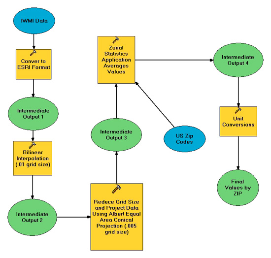
IWMI's data has been converted from ".grd" files into "ascii" files
and imported to ESRI ArcGIS version 9.3 for processing. The graphic
below summarizes all processing that has occurred to make this information
available on a summarized basis.
.
IWMI's data has been converted from ".grd" files into "ascii" files
and imported to ESRI ArcGIS version 9.3 for processing. The graphic
below summarizes all processing that has occurred to make this information
available on a summarized basis.
Return to the WaterSense Data Finder.


