Contact Pacific Southwest Waste Program
Pacific Southwest, Region 9
Serving: Arizona, California, Hawaii, Nevada, Pacific Islands, Tribal Nations
Rio Dell – The Clean Up and Redevelopment of a Small City

Located among towering redwood trees and adjacent to the magnificent Eel River in Northern California, the city of Rio Dell is working to develop its economy. Rio Dell is using a $200,000 Brownfields grant to evaluate contaminated and underutilized property located along its central business corridor. Petroleum contamination in this corridor can impact soil and groundwater with consequential adverse impacts to human health and the environment.
Settlers founded Rio Dell (population 3,250) and neighboring cities in the 1870s to support the region’s lumber industry. Rio Dell’s downtown economy has stagnated since the 1970s when the lumber industry began to decline and U.S. Highway 101 was rerouted from the downtown area to a route outside and away from the city. Consequently, retail activity suffered and numerous downtown gas/service stations n Rio Dell’s main street were abandoned.

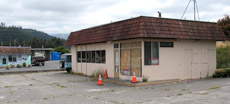
Rio Dell intends to clean up abandoned gas stations in its central business district.
The city, in consultation with EPA, has used the innovative “Triad” approach to site assessment and decision-making as they work on redeveloping the downtown area and revitalizing the economy . The Triad approach includes three key concepts: systematic planning, real-time measurements, and dynamic work strategies. More information on Triad » ![]()
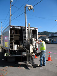
Rio Dell, EPA and the state of California collaborated to develop a triad based workplan. The centerpiece of the site assessment technologies utilized by Rio Dell is a tool known as a membrane interface probe (MIP). The MIP is a contaminant-screening tool, with semi-quantitative capabilities, that acts as an interface between the contaminants in the subsurface and gas phase detectors at the surface. The contaminant information is analyzed, plotted, and graphed at an on-site mobile laboratory. This allows the MIP operator to determine the location of contaminants and the relative concentration of contaminants in the soil or groundwater in which the contaminants are located. The MIP graph can then be used to determine the depth at which a monitoring well should be placed, at what depth samples need to be collected, or the interval for injection of remediation materials.

Collecting a sample with the Membrane Interface Probe.
The City of Rio Dell used the MIP to quickly gather subsurface contaminant information at its Brownfield sites to aid in guiding the collection of necessary soil and groundwater samples in areas of likely contamination. This allowed for a timely and more complete site characterization than is typically available under a traditional approach of multi-workplan/mobilization/sample collection efforts. With the assessment work quickly accomplished, Rio Dell is now able to quickly clean up and redevelop the area.
Rio Dell’s innovative approach to clean-up and redevelopment is allowing the city to support and promote economic growth in spite of its small size and limited budget.
Contact Information
Dave Hodges (hodges.dave@epa.gov)
RCRA Corrective Action Office
US Environmental Protection Agency
75 Hawthorne Street
San Francisco, CA 94105
(415) 947-4287
