Contact EPA Pacific Southwest Water Division
Pacific Southwest, Region 9
Serving: Arizona, California, Hawaii, Nevada, Pacific Islands, Tribal Nations
Watershed Priorities
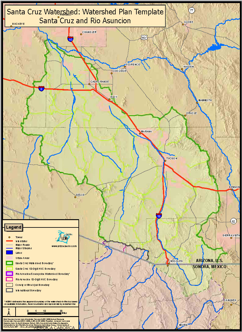
Santa Cruz Watershed, Arizona
On this page:
- Watershed Implementation Activities
- Border Activity
- Data
- Planning Documents
- Pollutants Santa Cruz Watershed impaired for
- Partners
- Resources
- Contact Information
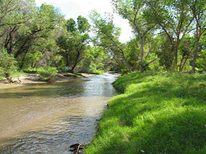
The Santa Cruz Watershed is defined as the drainage area of land that captures and transports surface and ground water within the basin. Some of the surface water sources in the Santa Cruz Watershed includes: Santa Cruz River, Sonoita Creek, Cienega Creek, Davidson Canyon, Harshaw Creek, Three "R" Canyon, Alum Gulch, Arivaca Lake, Parker Lake, and Lakeside Lake.
The Santa Cruz River has its headwaters in Arizona’s San Rafael Valley, which is in the south central part of the state. The river flows south and makes a 25-mile loop through Mexico before returning to U.S. soil about 5 miles east of Nogales, Arizona. The river then flows north from the U.S.-Mexican border up to its confluence with the Gila River, just southwest of Phoenix.
Most of the population in the Santa Cruz Watershed is found in the city of Tucson (population 530,000), the state’s second largest city. There is also a population of 370,000 located on the US-Mexico border in the sister border cities of Nogales, Sonora, Mexico and Nogales, Arizona. Grazing and irrigated crop production are the main land uses. Much of the agricultural land has been converted to urban use or retired. Mining is scattered across the watershed. The watershed includes eight designated wilderness areas, along with National Forests and National Parks with restricted land uses.
The Santa Cruz Watershed covers approximately 8,000 square miles, representing about 10% of the state of Arizona.
Watershed Implementation Activities
- Targeted Watershed Grant Program Provided the Sonoran Institute in Tucson, AZ
~$700,000 to conserve and augment water use in the Upper Santa Cruz Watershed.
- Non-Point Source Grants (XLS) (Excel file) – The Clean Water Act §319
NPS Program provides States with funding to implement watershed projects in impaired waters.
Border Activity
Since its inception in 1996, EPA's U.S.-Mexico Border Facilities Construction Program has committed funding to the planning/development/construction of four major projects in the Santa Cruz River watershed. EPA has provided $59.5 million for the upgrade of the Nogales International Wastewater Treatment Plant (NIWTP). This facility, which treats more than 14 million gallons per day (mgd) of wastewater from both Nogales, Arizona and Sonora and discharges it to the Santa Cruz River, is currently being improved to reduce contaminant loads of total nitrogen (including toxic loads of ammonia) and total suspended solids. Completion of the NIWTP upgrade is projected for the summer of 2009. EPA also supports projects to improve wastewater collection system infrastructure in both Nogales, AZ and SN, including projects that will provide new wastewater service connections to more than 35,000 users who currently discharge raw sewage to the environment and ultimately to the Santa Cruz.
Information on Nogales projects is available on the BECC and NADB websites. Also, environmental information (Environmental Assessments and Finding of No Significant Impact) are available for review on EPA's Border website.
Data
- WATERS
(Watershed Assessment, Tracking & Environmental ResultS) unites water quality information from several independent and unconnected databases. - STORET Data for Upper Santa Cruz
STORET (short for STOrage and RETrieval) is a repository for water quality, biological, and physical data and is used by state environmental agencies, EPA and other federal agencies, universities, private citizens, and many others.
Planning Documents
-
Integrated Report (AZDEQ)
 This report contains the status of the State's waters and a list of the impaired waters, commonly these reports are known as a CWA 305(b) report and CWA 303(d) list.
 - Santa Cruz River TMDL (PDF) (50 pp, 973K) (AZDEQ)
- TMDL Implementation Plan Alum Gulch
-
Watershed-based plan
- Santa Cruz Watershed Impaired Water Tracking Report (XLS) (Excel file)
This watershed is currently impaired for the following pollutants:
- Ammonia
- Chlorine
- Chlorophyll
- Copper
- Dissolved Oxygen
- Escherichia coli bacteria
- Mercury
- Nitrogen
- Low pH
- Phosphorus
- Zinc
Partners
- Arizona Department of Environmental Quality
- Arizona Department of Water Resources
- City of Tucson
- Coordinated Resource Management (CRM) A consortium of Federal and State agencies working with land users to better coordinate resource management.
- Friends of the Santa Cruz River
- Pima County
- Santa Cruz County
- Sonoran Institute
- Tohono O’odham Nation (including the San Xavier District located on the Santa Cruz River)
- Tucson Audubon Society
- US EPA - US-Mexico Border 2012: Arizona-Sonora Workgroup
- US National Parks Service - Tumacacori
- United States Geological Survey
- University of Arizona - NEMO
Resources
- EPA's Watershed Central
Watershed Central has been designed to assist users to develop and implement effective watershed management programs. The site includes guidance, tools, case studies, and data sets to help you share information, analyze data, and identify opportunities to initiate or strengthen your watershed efforts. - EPA's Watershed Webcasts
Watershed Academy Webcast Seminars
Contact Information
Jared Vollmer (Vollmer.Jared@epa.gov)(415) 972-3447