Contact EPA Pacific Southwest Water Division
Pacific Southwest, Region 9
Serving: Arizona, California, Hawaii, Nevada, Pacific Islands, Tribal Nations
Bolsa Chica Wetland Restoration Project Description
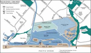
The Bolsa Chica Lowlands Restoration Project is in Orange County, California, adjacent to the City of Huntington Beach (see Figure 1, below). The purpose of the project is to restore portions of the wetland ecosystem of the Bolsa Chica lowlands. The project area covers about 1,247 acres and will restore tidal influence from the Pacific Ocean to about half of this area to reinvigorate the wetland ecosystem.

Figure 1. Diagram of Bolsa Chica Wetlands Restoration Project features
(view a larger version of this map)
To achieve the biological benefits of tidal restoration, a direct connection to the Pacific Ocean will be reestablished through the excavation of a new tidal inlet across Bolsa Chica State Beach and the Pacific Coast Highway. Construction is anticipated to start in October 2004 and span 2.5 to 3 years, in order to reduce impacts to fish and wildlife resources, coastal traffic, and beach recreation.
The Pacific Coast Highway and remaining active oil field facilities will remain in operation during the entire construction period.
Full-tidal basin
A 366-acre tidal basin will be constructed to receive full tidal action via the new ocean inlet. About 2.7 million cubic yards (cy) of material (mostly clean sand) will be removed from the basin to depths between 6.0-6.8 feet below mean sea level (MSL). Much of the excavated material will be used in other project features. For example, it will be used to 1) pre-fill an ebb bar (1,300,000 cy), 2) build levees for the full-tidal basin (456,000 cy), 3) create three nesting areas (366,000 cy), 4) provide beach nourishment (190,000 cy), and 5) create an inter-tidal shelf for growth of cordgrass (98,300 cy). As much as 253,000 cy of the excavated material unsuitable for these purposes may be hauled off site.
Muted-tidal basin
A 200-acre muted-tidal basin will be connected to the full-tidal basin via box culverts and weirs. The boxed culverts will include water-control structures to regulate the extent of tidal influence. Tidal channels and overflow structures will also be constructed.
Muted-tidal basin in the Bolsa pocket area
This 42-acre parcel on the north side of the East Garden Grove-Wintersburg Flood Control Channel is presently hydrologically-isolated. Hydrologic connections will be made to Outer Bolsa Bay adjacent to the tide gates at the mouth of the Flood Control Channel, inasmuch as the water quality within the Flood Control Channel is unsuitable for wetland restoration.
Nesting habitat islands
Three nesting areas will be created on 20 acres within the site for endangered species, including the western snowy plover and California least tern. Nesting areas will be constructed using 366,000 cubic yards of material excavated from the full-tidal basin.
Ocean inlet
A 360-foot-wide ocean inlet will be excavated to the full tidal basin, covering an area of approximately 3.7 acres. Approximately 190,000 cubic yards of the excavated sand will be placed on the adjacent Bolsa Chica State Beach for beach nourishment.
Pacific Coast Highway bridge and retaining walls
To cross the new ocean inlet, a bridge will be constructed within the existing alignment of the Pacific Coast Highway (PCH) between Bolsa Chica State Beach and the Bolsa Chica Wetlands Restoration Project. The bridge will accommodate the existing four traffic lanes and will include a separate safety vehicle lane-bike path along Bolsa Chica State Beach. Roadway drainage improvements will be constructed in the vicinity of the inlet and bridge. Use of retaining walls will minimize land requirements along the west side of the bridge. The recommended 420-foot bridge design has been approved by CalTrans, and is a ten-span, cast-in-place, deck-slab structure. During bridge construction, traffic will be maintained via a detour along the inland edge of the existing right-of-way.
Entrance jetties
To stabilize the inlet, two jetties will be constructed to prevent the entrance channel from closing. Each jetty will extend approximately 450-feet long into the ocean from Pacific Coast Highway. Each jetty will be about 100-feet wide at its base. About 5 acres of the beach will be excavated to construct the jetties and the inlet. The jetties will contain approximately 72,000 tons of rock.
Shoreline and bridge revetments
Approximately 750 feet of shoreline revetment will be constructed on each side of the jetties on the west side of the project’s bridge on the Pacific Coast Highway. Following construction, they will be buried under beach sand. The total amount of rock in these is 31,000 tons. In addition, a revetment would be placed east of the bridge for erosion protection in the flood shoal management area of the full tidal basin. The total amount of rock in these is about 138,000 tons.
Ebb shoal
To maintain beach stability, an ebb shoal will be constructed outside the inlet mouth. The equilibrium volume of the ebb shoal will be approximately 620,000 cubic yards of sandy material. To provide additional safety, it is proposed to place as much as 1,300,000 cubic yards of sandy material (> 80% sand) in the proposed ebb shoal, covering approximately 45 acres of existing soft-bottom substrate.
Oil service bridge
To maintain existing oil field operations on a parcel isolated by the new ocean inlet, a two-lane oil service bridge will be constructed parallel to the PCH bridge. The bridge structure will include a ten-span cast-in-place deck-slab structure, 420-feet long supported on driven concrete piles meeting the same standards as the PCH bridge. This two-lane structure will also include a utility platform to accommodate production lines for oil field operations, including oil, gas, and water lines in casings.
Groundwater barrier
An approximately 10,000-feet-long barrier will be constructed to prevent groundwater and salinity intrusion into the adjacent neighborhoods. The salinity intrusion barrier will be as deep as 30 feet. A French drain to control shallow groundwater levels will be as deep as 10 feet, and will include several pump stations that will discharge into the muted tidal basin.
