Contact EPA Pacific Southwest Water Division
Pacific Southwest, Region 9
Serving: Arizona, California, Hawaii, Nevada, Pacific Islands, Tribal Nations
Feather and Sacramento Rivers Watersheds
On this page:
The Watersheds
Partners & Contact Info
Central Valley Regional Water Quality Control ![]() is the State regional water quality agency responsible for implementing the federal Clean Water Act as well as state water quality laws and regulations in the Central Valley of California.
is the State regional water quality agency responsible for implementing the federal Clean Water Act as well as state water quality laws and regulations in the Central Valley of California.
Contacts
Central Valley Regional Water Quality Control Board
Daniel McClure, P.E., (dmcclure@waterboards.ca.gov),
Water Resources Control Engineer
(916) 464-4751
US EPA Region 9,
Erin Foresman (foresman.erin@epa.gov)
(916) 557-5253
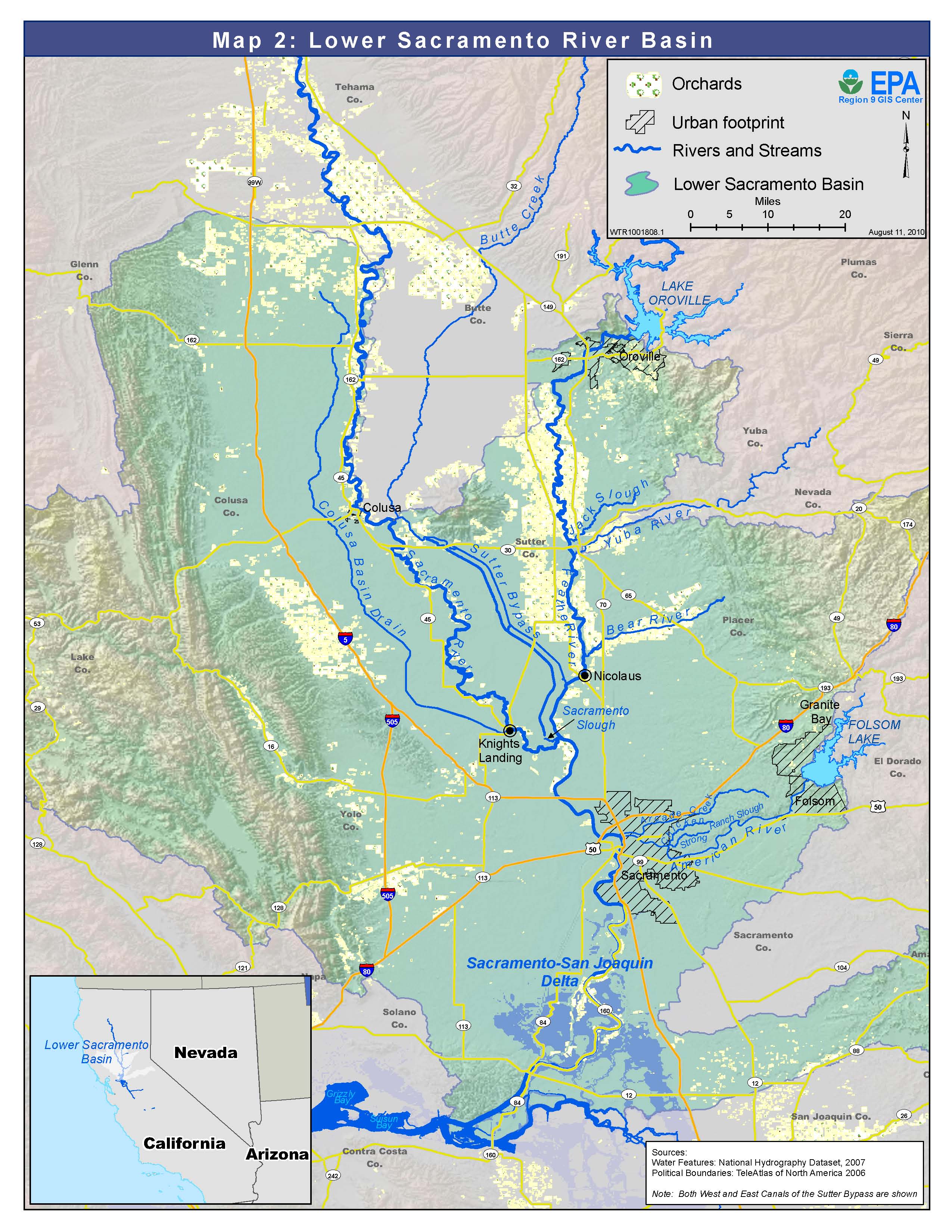
The Sacramento and Feather Rivers are located in the Lower Sacramento Basin, one of the upper watersheds within the greater San Francisco Bay-Delta Estuary watershed. The Sacramento Valley makes up the northern one third of California’s Great Central Valley.
The Sacramento River is the largest river within the state of California by flow, length, and drainage area. The lower Feather River is the largest natural tributary to the Sacramento River. The Sacramento River meets California’s second longest river, the San Joaquin River, south of the City of Sacramento where they merge into the Sacramento-San Joaquin Delta. The Delta then drains into the San Francisco Bay-Delta Estuary and Pacific Ocean.
Agriculture dominates land use in the watershed. Sacramento River Valley agricultural land use covers about 2,159,903 acres: rice = 25.3% (547,301 acres); deciduous fruits and nuts = 16 % (336,366 acres); and grain and hay crops = 15 percent (322,569 acres). With over 2 million people living in the watershed, urban land use is concentrated around the cities of Sacramento, Redding, Chico and Red Bluff.
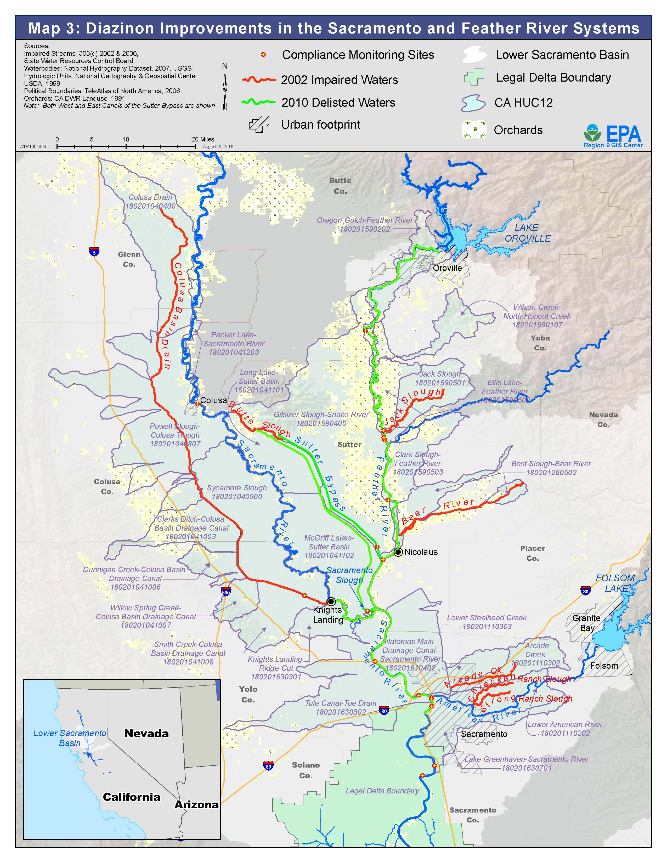
Water quality in the Sacramento and Feather Rivers has been identified by the State of California as impaired by copper, mercury, toxicity and more than 15 pesticides including diazinon chlorpyrifos and lindane. (California 2006 303(d) List of Impaired Waters (PDF) (299 pp, 1.1M) ![]() )
)
Watershed stakeholders at all levels are working to restore these impaired watersheds and while some progress has been achieved, much work remains to be done. EPA recognizes restoration success will involve a watershed approach relying on both regulatory and non-regulatory mechanisms.
Progress and Environmental Results
Full Report Documenting Watershed Wide Improvement (EPA Strategic Measure SP12) Improving CA Central Valley Watersheds: Diazinon Reduction in the Feather and Sacramento Rivers (PDF) (21 pp, 1.6M)
EPA is tracking progress to restore watersheds and water quality throughout the nation (see EPA National Water Program Strategic Plan and Guidance). One measure of progress is where improved water quality conditions in impaired watersheds have been achieved by implementing a watershed approach (see: SP-12).
Under this measure (SP12), in 2010, EPA and the Central Valley Regional Water Board produced a report to document the successful efforts to eliminate diazinon impairments in the Feather and Sacramento River watersheds. Access the full report: "Improving California Central Valley Watersheds: Diazinon Reduction in the Feather and Sacramento Rivers (PDF)" (21 pp, 1.6M).
The success of the watershed approach in reducing diazinon impairments in Central Valley water bodies is a model for future water quality restoration efforts. Continuing watershed-based pollution control activities can successfully address ongoing water quality challenges in the Lower Sacramento Basin by combining community-based watershed activities with regulation. Persistent water quality problems in the Central Valley include the remaining 117 diazinon-impaired river miles, the replacement of diazinon with pyrethroid pesticides (highly toxic in the aquatic environment), and thousands of river miles that have other pesticide, nutrient, metals and toxicity water quality impairments. Lessons learned from these efforts focus future actions and strengthen partnerships that continue to work toward improving water quality in the Central Valley and beyond.
Reducing Diazinon – A Watershed Approach
Sources of diazinon include agricultural and urban storm water discharges. Diazinon is applied to orchards growing plums, peaches, and almonds to control destructive pests such as spider mites, boring insects, and aphids.
Community, business, education, research, and regulatory activities resulted in the reduction of diazinon concentrations in the Sacramento and Feather River systems. A diverse group of stakeholders, motivated by the basic need for clean water and impending regulation, developed a variety of tools to reduce the use of diazinon and control polluted runoff from reaching waterways. Their combined efforts resulted in the removal of 79 river miles from the 303(d) List for diazinon impairments by 2010.
Map 1 shows the waterbodies identified as impaired by diazinon in 2002. The waterbodies identified in green on Map 3 show the waterbodies no longer impaired by diazinon following restoration efforts.