Contact EPA Pacific Southwest Water Division
Pacific Southwest, Region 9
Serving: Arizona, California, Hawaii, Nevada, Pacific Islands, Tribal Nations
Watershed Priorities
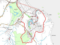
Kaelepulu Watershed, Oahu, Hawai’i
Multiple local, state and federal water programs are being applied to support protection of the Kaelepulu Watershed on the Hawaiian island of Oahu.
Watershed Features
Downstream from the Pond, Kaelepulu stream flows to Kailua Bay at Kailua Beach Park. Under normal flow conditions, a naturally forming sand bar blocks the stream and holds back discharges. On an approximately monthly basis the City and County of Honolulu Department of Facility Maintenance, Roads Division, removes the sand bar, allowing the stream to discharge into Kailua Bay. Tidal action results in the reformation of the sand bar. Hamakua Canal, flowing eastward through the Hamakua Marsh, is also part of the watershed. The Canal discharges into Kaelepulu stream approximately one-half mile downstream of Kaelepulu Pond and one-half mile upstream of Kailua Bay.
The Kaelepulu Stream is listed on Hawai’i’s 303(d) list of impaired waters due to turbidity, nutrients, bacteria, and chlorophyll pollution. Potential sources of these contaminants include storm water runoff, septic tanks/cesspools, sanitary sewer overflows, domestic and wild animals, along with lakebed and water column processes.
Federal large capacity cesspool closure
A series of large capacity cesspools (LCCs) are used for wastewater disposal at apartment buildings located along parts of the 300, 400, and 500 blocks of Kailua Road. Under federal regulations, LCCs are required to be closed as of April 5, 2005. EPA has entered into consent agreements with property owners and lease holders to have these cesspools closed. The City and County of Honolulu is scheduled to extend sewer services into this area by late 2007.
For more information about implementation of the LCC ban in Hawaii, see the UIC-cesspools Web page.
Hawai'i State programs
Using EPA grant funds, the Hawai’i Department of Health (HDOH) is establishing Total Maximum Daily Loads (TMDLs) for those constituents in Kaelepulu Stream which exceed State Water Quality Standards. HDOH has established the Kaelepulu TMDL work group to involve local community members as well as local, state and federal government representatives. The work group has become a valuable forum for raising a range of water issues from possible wetlands encroachment to volunteer water quality monitoring. Grant funds are being used to prepare a scoping report to document factors such as watershed hydrology and pollutant sources. Based on this scoping report, a Sampling and Analysis Plan will be prepared to monitor water quality for TMDL development. The Sampling and Analysis Plan will also cover performance of a Sanitary Survey, which will investigate septic tanks and cesspools in the Watershed.
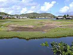
HDOH is providing EPA nonpoint source grant funds to the Enchanted Lakes Residents Association (ELRA) to remove mangrove and trash from Kaelepulu Pond. In Hawai’i, mangrove are alien and invasive species, and do not typically support enhanced water quality objectives. Mangrove removal will be accomplished with the assistance of State Division of Forestry and Wildlife. This activity supports the Ko’olaupoko Watershed Masterplan, and supports the Management Measure for Hydromodification in the State’s Coastal Nonpoint Pollution Control Plan. Reports prepared by the ELRA as part of this effort are indicating trash loading rates, stormwater volumes and sediment inputs. This information is being integrated into the State’s TMDL development.
HDOH has also provided nonpoint source grant funds to the Kailua Bay Advisory Committee (KBAC), which is working to protect the larger Ko’olaupoko regional area. KBAC is utilizing these funds on a demonstration/education project for implementation of best management practices at parks. This effort will include a focus on the park lands adjacent to Kaelepulu Pond. In addition, a pending watershed-based plan for Ko’olaupoko watershed would also include Kaelepulu.
In 2003, EPA provided a grant to the Hawaii Department of Land and Natural Resources (DLNR) for the Hamakua Wetland Restoration and Monitoring Program at the Hamakua State Wildlife Sanctuary. Activities funded by this grant include monitoring of water quality and invertebrates. An objective of this monitoring is to document baseline conditions of restored tropical coastal wetlands that can be used elsewhere in Hawaii and other tropical locations. Nest and bird counts are being conducted in re-established habitats for native Hawaiian waterbirds and migratory shorebirds. DLNR invites community members to participate in monitoring efforts and caring for these wetlands. Interested volunteers may contact mcguirec@hawaii.edu.
City and County of Honolulu projects
The City and County of Honolulu (CCH) is also implementing projects to improve water quality in the watershed. In order to reduce sewer spills during rainfall events, CCH has conducted a smoke testing program to ensure that rainwater is not being discharged into the City’s sewer system. Within the Enchanted Lake area, over 150 sources of infiltration to the sewer system have been identified. Where illegal connections (e.g. from rainwater downspouts) to the sewer system exist, they will need to be disconnected from the sewer system. CCH has also contracted to have an evaluation performed of discharges from the City’s storm water system into Kaelepulu Pond. Recommendations will be made on possible structural best management practices that can be implemented to protect water quality. It is anticipated that funding for implementing these measures will be sought from the CCH Capital Improvement Project budget.
EPA contact information
U.S. EPA Region IX
75 Hawthorne Street (WTR-10)
San Francisco, CA 94105
(415) 947-8707