Contact EPA Pacific Southwest Air Program
Pacific Southwest, Region 9
Serving: Arizona, California, Hawaii, Nevada, Pacific Islands, Tribal Nations
Using Technology to Assess Air Quality in the San Joaquin Valley
Technical information
on this page:
It may sound like fiction - NASA pilots, EPA scientists, lidar instruments, and an airplane flying back and forth over the San Joaquin Valley - but it is a fact.
Last week, in an effort to better understand how particulate matter pollution is formed, EPA teamed up with NASA scientists to bring advanced monitoring technology to the valley.
Air pollution is easily trapped inside a valley and the San Joaquin Valley is long, low, and surrounded by mountains on three sides. The recent population boom, busy highways, and other sources of pollution have combined with the natural topography to create some of the highest concentrations of fine particulate pollution in the country. Improving the valley’s air for the 3.3 million people who live there is a priority for EPA.
The plane that flew over the valley was equipped with lidar, an advanced monitoring instrument from NASA that makes unique aerosol (particulate matter) measurements. These measurements give a downward snapshot of the entire aerosol that is in the atmosphere. (See the graphic below.) The measurements are useful for assessing the sources and transport of the aerosol.
The data gathered during the flights can help us better understand the underlying science of particulate matter pollution and help the San Joaquin Valley Air Pollution Control District develop more informed air quality plans. EPA will continue to work with the California Air Resources Board and the SJV APCD, as we strive toward the same goal - cleaner air for the valley residents.
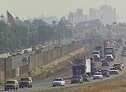
Particulate pollution in the San Joaquin Valley
|
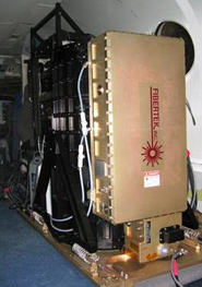
Air monitoring equipment (lidar) aboard the NASA Study plane
|
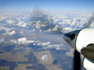
Aerial photo of San Joaquin Valley, from NASA study plane
|
How NASA's Satellites Helped with Air Sampling
Graphic courtesy of NASA
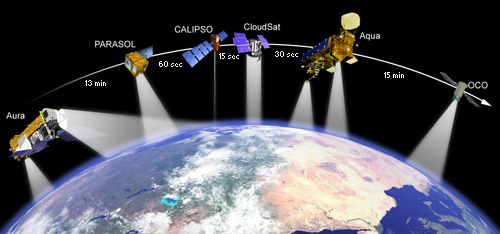
This graphic depicts several of NASA's satellites flying in formation high above the earth's surface. The NASA flights were timed to overlap with the Aqua satellite (shown here as second from right) overpass above San Joaquin Valley, which takes place daily at 1:30pm local time. Researchers will use the aircraft's aerosol measurements as a vertical link between aerosol data from the Aqua satellite and ground-based measurements of PM-2.5 to demonstrate the utility of satellite data for measuring surface air quality.
High Spectral Resolution Lidar Aerosol Vertical Profile Data
Graphic courtesy of NASA Langley Research Center
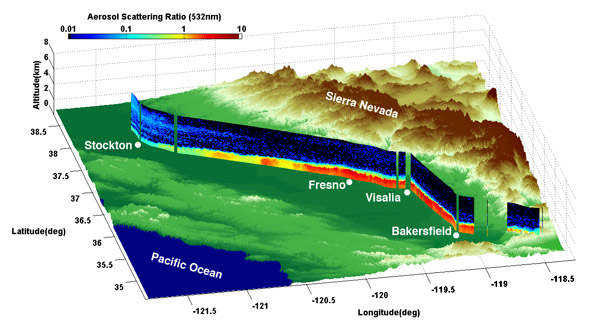
High Spectral Resolution Lidar (HSRL) aerosol vertical profile acquired between 14:00 and 15:00 PST on Feb. 15 2007 as the NASA Langley King Air B200 aircraft flew north over the eastern San Joaquin Valley. This image shows one of the parameters measured by the HSRL, the aerosol scattering ratio, and demonstrates that the aerosols were mostly confined to the southern part of the Valley and below 1.5km. Note: This data is preliminary and has not yet been finalized.
Contact Information
Rebecca Rosen (rosen.rebecca@epa.gov)
(415) 947-4152