EnviroAtlas Spatial Extents
EnviroAtlas data are developed for two primary spatial extents:
- National - Data covering the nation.
- Community - Data covering select communities at a higher resolution.
Additional maps, such as demographics, boundaries, and land cover data, provide context for the national and community extents.
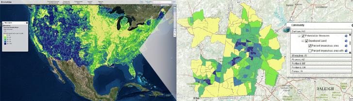 Example images showing EnviroAtlas spatial extents. National data (left) are aggregated to 12-digit HUCs, while community data (right) are aggregated to census block groups.
National Data
- Most maps at the national extent provide wall-to-wall data coverage for the contiguous U.S. as well as some data for Alaska and Hawaii. There are approximately 300 data layers at this extent.
- These data layers are summarized by 12-digit hydrologic unit codes (12-digit HUCs), or sub-watershed basins, and provide approximately 90,000 similarly sized spatial units. Many of these data layers are derived from data with a resolution of 30 m.
- Ecosystem Markets data layers are also available for the nation, showing point and polygon data for ecosystem market initiatives and enabling conditions operating at a variety of scales, from national to local.
EnviroAtlas Interactive Map

Community Data
- Community-level information in EnviroAtlas draws from fine scale land cover data, census data, and models. There are approximately 100 data layers per community.
- EnviroAtlas community data are consistent for each available community, and they are mostly summarized by census block groups.
- Each community area boundary is based on selected block groups within the 2010 US Census Urban Area boundary.
- EnviroAtlas plans to incorporate 50 communities by 2019. See a list of the available and upcoming communities.
Supplemental Data
These data are available for both the nation and selected communities.
- They provide context and additional data for exploring ecosystem services and the built environment.
- These data are not summarized by a specific spatial unit. Instead, supplemental maps represent features in the landscape such as rivers and wetlands, other contextual landmarks such as state boundaries, and the 1 meter resolution land cover data for each community.
People and Built Spaces Data
These data are available for both the nation and selected communities.
- Demographic data at the national extent are available for the contiguous U.S. and are summarized by census tract.
- Demographic data at the community extents are available for each EnviroAtlas community and are summarized by census block group.
- Approximately 40 data layers summarizing demographic, employment, and built environment variables are available for every census block group in the U.S.