Cleanups - Where You Live
Site-Specific, National Cleanup Data Sources
- Cleanups in My Community enables you to search for sites by street address, city, county, state, territory and other geographies, and drill down to more details to find out how EPA's Superfund, RCRA, Brownfields and Emergency Response programs are cleaning up land in communities across the USA. CIMC provides maps with additional contextual data, as well as tables for printing and downloading.
- Other National Data Sources with Cleanup Data
Regional, State, Territory and Tribal Cleanup Maps and Listings

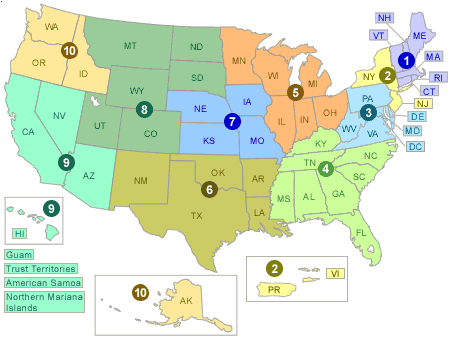
This map links to maps of cleanups in each region, with the option to quickly add contextual information such as: impaired waters, water and air monitoring stations, sea level rise, flood zones, and congressional districts. The listings below link you to cleanup program information for each EPA Region, and individual cleanup listings by state. Please see Cleanups in My Community for more mapping and listing options including mapping by state, tribe and/or program.
Region 1
- Regional cleanup page and listing of sites
- Cleanups listings by States: Connecticut, Maine, Massachusetts, New Hampshire, Rhode Island, Vermont and ten Indian Tribes
- Additional Region 1 Cleanup Links: Brownfields
Region 2
- Regional listing of sites
- Cleanups listings by States: New Jersey, New York, Puerto Rico, US Virgin Islands and seven Indian Tribes
- Additional Region 2 Cleanup Links: Brownfields | RCRA Corrective Action
Region 3
- Regional listing of sites
- Cleanups listings by States: Delaware, District of Columbia, Maryland, Pennsylvania, Virginia, and West Virginia
- Additional Region 3 Cleanup Links: Brownfields | RCRA Corrective Action | Oil Spills
Region 4
- Regional listing of sites
- Cleanups listings by States: Alabama, Florida, Georgia, Kentucky, Mississippi, North Carolina, South Carolina and Tennessee
- Additional Region 4 Cleanup Links: Brownfields
Region 5
- Regional cleanup page and listing of sites
- Cleanups listings by States: Illinois, Indiana, Michigan, Minnesota, Ohio, Wisconsin and five Indian Tribes
- Additional Region 5 Cleanup Links: Brownfields | RCRA Corrective Action
Region 6
- Regional listing of sites
- Cleanups listings by States: Louisiana, Arkansas, Oklahoma, New Mexico, Texas and 66 Indian Tribes
- Additional Region 6 Cleanup Links: Louisiana | Arkansas | Oklahoma | New Mexico | Texas | Brownfields | RCRA Corrective Action
Region 7
- Regional listing of sites
- Cleanups listings by States: Iowa, Kansas, Missouri, Nebraska and nine Indian Tribes
- Additional Region 7 Cleanup Links: Iowa | Kansas | Missouri | Nebraska | Brownfields | RCRA Corrective Action | Spills
Region 8
- Regional listing of sites
- Cleanups listings by States: Colorado, Montana, North Dakota, South Dakota, Utah, Wyoming and 27 Indian Tribes
- Additional Region 8 Cleanup Links: Brownfields | Superfund sites
Region 9
- Regional cleanup page and listing of sites
- Cleanups listings by States: Arizona, California, Hawaii, Nevada, the Pacific Islands (Guam, American Samoa, Northern Mariana Islands, and Trust Territories) and 147 Indian Tribes
- Additional Region 9 Cleanup Links: Arizona | California | Hawaii | Nevada | Pacific Islands | Brownfields | Leaking Underground Tanks | RCRA Corrective Action | Superfund | Emergencies and Spills
Region 10
- Regional cleanup page and listing of sites
- Cleanups listings by States: Alaska, Idaho, Oregon, Washington and 267 Indian Tribes
- Additional Region 10 Cleanup Links: Alaska | Idaho | Oregon | Washington | Brownfields | RCRA Corrective Action | Superfund
