RadMap
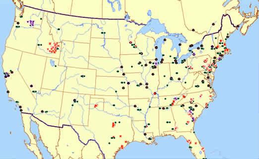
Designed for use by emergency responders, especially when the internet is unavailable, RadMap is an interactive desktop tool featuring a nationwide geographic information systems![]() geographic information systemsA system for linking information to a particular geographical location. A Geographic Information System (GIS) allows users to manipulate and analyze specific provided data. (GIS) map of long-term radiation monitoring locations across the United States with access to key information about the monitor and the area surrounding it.
geographic information systemsA system for linking information to a particular geographical location. A Geographic Information System (GIS) allows users to manipulate and analyze specific provided data. (GIS) map of long-term radiation monitoring locations across the United States with access to key information about the monitor and the area surrounding it.
- What is RadMap?
Designed for use by Emergency Responders
RadMap is an interactive desktop tool featuring a nationwide geographic information systems
 geographic information systemsA system for linking information to a particular geographical location. A Geographic Information System (GIS) allows users to manipulate and analyze specific provided data. (GIS) map of long-term radiation monitoring locations across the United States with access to key information about the monitor and the area surrounding it.
RadMap is a stand-alone GIS map that is available for emergency response communities.
- What is it used for?
In the event of a Radiation Release
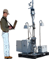
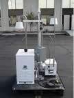
RadMap can help emergency responders collect information, develop assessments, and determine the placement of deployable monitors. Desktop access could be critical should other systems fail in an emergency. RadMap helps EPA in its Homeland Security responsibilities and it was recommended by the Conference of Radiation Program Directors and EPA’s Science Advisory Board (SAB).
- What is the purpose of RadMap?
Radiation Monitoring
The objective of RadMap is to provide a national resource for emergency responders and other practitioners in radiological information. Today, radiological topics are often in the forefront of news stories, and we hope that RadMap will be seen as a resource used to foster the growth and development of radiological awareness.
- How can it be used?
RadMap provides easy access to:
- Monitor locations.
- Points of contact for specific monitoring systems.
- What data is being collected and how often.
- Real-time and long-term data, where available online.
- Geographic features such as nearby roads and bodies of water.
- Mileage of locations from other points on the map.
Users can highlight an area to identify key information about the monitor and to characterize the monitor location.
- RadMap Spatial Accuracy
- 1 o = 60 nautical miles or ~ 69 statute miles.
- 0.1 * 69 miles = 6.9 miles.
- 0.01 * 69 miles = 0.69 miles.
- 0.001 * 69 miles = 0.069 miles = 364 feet.
- 0.0001 * 69 miles = 0.0069 miles = 36.4 feet.
- 0.00001 * 69 miles = 0.00069 miles = 3.64 feet.
- 0.000001 * 69 miles = 0.000069 miles = .364 feet = 4.4 inches.
To six decimal places, the White House is at latitude 38.898748 longitude -77.036521, so changing the last 8 to a 9 in the longitude would be a difference of 4.4 inches.