About Manistique River AOC
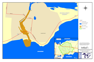 Printable boundary map and shapefile of Manistique River AOC
The Manistique River flows southwest through Schoolcraft County in Michigan's central Upper Peninsula, discharging into Lake Michigan at Manistique. It was named an AOC under the Great Lakes Water Quality Agreement of 1987.
The highly degraded area contained:
- historical waste from sawmills, a paper mills, and small industries
- High level PCB sediment contamination
- Prior Superfund cleanup
The Area of Concern includes:
- The last 1.7 miles of Manistique River
- The Manistique Harbor at the mouth of Lake Michigan
Beneficial Use Impairments
- Restrictions on fish and wildlife consumption
- Degradation of benthos – REMOVED 2006
- Restriction on dredging activities
- Beach closings – REMOVED 2009
- Loss of fish and wildlife habitat – REMOVED 2008
A collaboration of local, state and federal organizations are working together to complete the last remaining restoration actions needed to delist the Manistique River Area of Concern. These actions will address the contamination causing fish consumption advisories and restrictions on dredging activities.