NHDPlus (National Hydrography Dataset Plus)
 National Hydrography Dataset Plus (NHDPlus) is a national geospatial surface water framework (geofabric). Geospatial analysts and modelers use this framework to support water resources applications. The U.S. EPA developed and maintains NHDPlus in partnership with the U.S. Geological Survey.
You will need Adobe Reader to view some of the files on this page. See EPA’s About PDF page to learn more. You may need additional software to view some of the links on this page. See EPA’s Free Viewers and Readers page.The links will vary in file size.
Basic Information about National Hydrography Dataset Plus (NHDPlus)
NHDPlus is a suite of geospatial products that build upon and extend the capabilities of the National Hydrography Dataset (NHD), the National Elevation Dataset (NED) and the Watershed Boundary Dataset (WBD). Interest in estimating stream flow volume and velocity to support pollutant dilution (fate-and-transport) modeling was the driver behind the joint U.S. Environmental Protection Agency and U.S. Geological Survey effort to develop NHDPlus.
Since NHDPlus is produced from static snapshots of the NHD, NED and WBD, it includes the features and capabilities of these ingredient datasets. NHDPlus integrates the vector NHD stream network and WBD hydrologic unit boundaries with the NED gridded land surface. This hydrologically-conditioned surface enables the delineation of a catchment (local drainage areas) for each NHD stream segment. The catchments are used to associate precipitation, temperature and runoff data with each stream segment for estimating NHDPlus stream flow.
Elevations along each stream are used to compute stream slope for estimating NHDPlus velocities used in time of travel analyses. In addition to stream flow and velocity, NHDPlus provides additional value-added attributes, including stream order and a group of attributes that facilitate rapid stream network traversal and query. NHDPlus catchments are used to associate other landscape attributes, such as land cover, with stream segments.
These capabilities enable a diverse collection of water-related applications implemented by a large and growing user community. The widespread positive response to initial NHDPlus Version 1 (NHDPlusV1), released in 2006, prompted the multi-agency NHDPlus team to design an enhanced NHDPlus Version 2 (NHDPlusV2) that was released in 2012.
Since the significantly improved NHDPlusV2 is intended to supercede NHDPlusV1, new and existing NHDPlus users are strongly encouraged to use NHDPlusV2. While the NHDPlusV1 data, metadata and documentation remains available from this site, user support for the NHDPlusV1 will be increasingly limited. The NHDPlusV2 User Guide (PDF)(182 pp, 4.4 MB) Exit describes the differences between the two versions.
Download NHDPlus Version 2 (NHDPlusV2) Data
NHDPlusV2 benefits from significant improvements to its primary ingredient datasets as well as a more robust stream flow estimation process, which incorporates runoff estimates from a USGS national water balance model. There are also new components, such as, excess potential evapotranspiration, major water withdrawals and additions and network-interpolated adjustments to align with gaged flows.
NHDPlusV2 consists of the following components:
- Greatly improved 1:100K National Hydrography Dataset (NHD).
- Greatly improved 30 meter National Elevation Dataset (NED).
- Nationally complete Watershed Boundary Dataset (WBD).
- A set of value added attributes to enhance stream network navigation, analysis and display.
- An elevation-based catchment for each flowline in the stream network.
- Catchment characteristics.
- Headwater node areas.
- Cumulative drainage area characteristics.
- Flow direction, flow accumulation and elevation grids.
- Flowline min/max elevations and slopes.
- Flow volume & velocity estimates for each flowline in the stream network.
- Catchment attributes and network accumulated attributes.
- Various grids from the hydro-enforcement process including the hydro-enforced DEM.
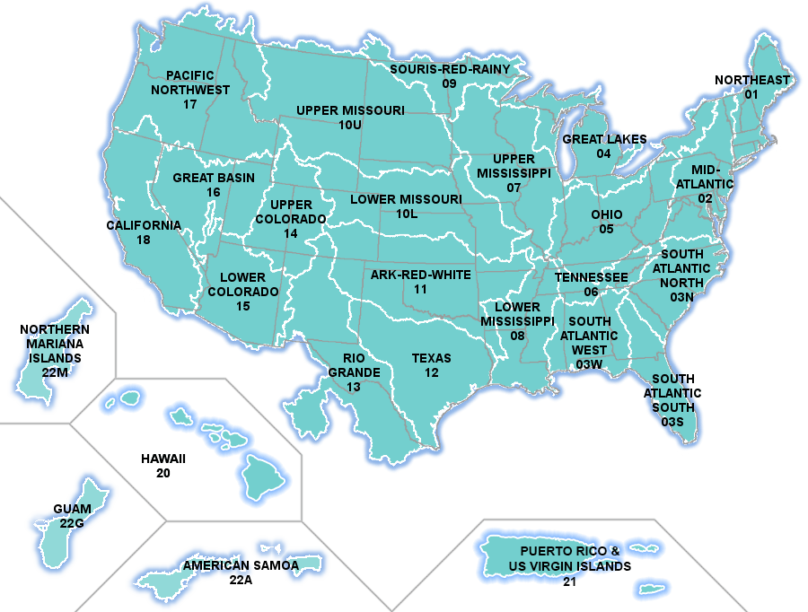
NHDPlusV2 attribute and vector data are distributed by hydrologic regions (HUC2) or, in the case of regions 10 and 03, parts of hydrologic regions. These regions or parts of regions are called Vector Processing Units (VPUs). The NHDPlusV2 raster components are distributed by sub-parts of VPUs called Raster Processing Units (RPUs). A national shapefile of the VPU and RPU boundaries is available.
In addition to the user guide and metadata, the release notes that are posted with each VPU contain supplemental information describing data lineage.
NHDPlusV2 Data Map
Select the data region of your choice by clicking on the map below or selecting the name from the list.
Learn More about NHDPlus
We encourage first-time users to familiarize themselves with the NHDPlusV2 User Guide (PDF)(182 pp, 4.4 MB) Exit and complete the NHDPlus training exercises (under "Documentation" below) before starting to work with NHDPlus data.
- Documentation
- NHDPlusV2 Metadata
- NHDPlusV2 Technical Documents
- NHDPlusV2 Training
- NHDPlusV2 Presentations
- NHDPlus Versioning
- NHDPlus Flyer
The following links are to non-federal government sites Exit
NHDPlusV2 Metadata
NHDPlus Version 2 Metadata, Metadata in XML
Download NHDPlus Version 2 metadata and Extended Metadata components from the links below:
- NHDPlusV2 Metadata (ZIP)
- National Hydrography Dataset Metadata (ZIP)
- National Watershed Boundary Dataset Metadata (ZIP)
- National Elevation Dataset, August 2010 Metadata (ZIP)
- National Elevation Dataset, February 2011 Metadata (ZIP)
- National Elevation Dataset, June 2011 Metadata (ZIP)
- National Elevation Dataset, August 2011 Metadata (ZIP)
- National Elevation Dataset, December 2011 Metadata (ZIP)
- National Elevation Dataset Data Dictionary, August 2010 (ZIP)
- Canadian Digital Elevation Data Metadata (ZIP)
- Canadian Digital Elevation Data Index Polygons (ZIP)
NHDPlusV2 Technical Documents
NHDPlusV2 Training
Exercise Data
Use the links below to obtain the data necessary for performing the exercises.
Exercises
- Exercise 0 - Installing Tools and Data (PDF)
This exercise is a prerequisite for all other exercises. It provides instructions for acquiring the data and the tools needed to complete the other exercises. - Exercise 1 - Setting Up the Data (PDF)
In this exercise, you'll learn: (1) how to obtain and install NHDPlusV2 data; (2) how to use a special NHDPlusV2 tool to quickly build indexes and pyramids; and (3) an easy method for keeping your NHDPlusV2 data up to date. - Exercise 2 - Linking Data to NHD (PDF)
In this exercise, you'll learn how to use the NHD linear referencing system to link data to the NHD stream network in NHDPlusV2. - Exercise 3 - Navigating With Geometry (PDF)
In this exercise, you'll learn how to navigate the NHD stream network using the geometry of the stream network features. - Exercise 4 - Navigating with the Flow Table and With VAAs (PDF)
In this exercise, you'll learn how to navigate the NHD stream network using the NHDPlusV2 flow table and using the NHDPlusV2 VAAs with tools built specifically for that purpose. - Exercise 5 - Network Analysis (PDF)
This exercise combines what you learned in exercises 2, 3, and 4 to illustrate network analysis using NHDPlusV2. - Exercise 6 - Raster Datasets (PDF)
NHDPlusV2 contains many raster datasets. In this exercise, you'll learn how best to use raster data and how to symbolize NHDPlusV2 raster data in a map. - Exercise 7 - Watershed Delineation (PDF)
In this exercise, you'll learn how to delineate a watershed (the drainage area upstream) from a point along the stream network. - Exercise 8 - NHDPlusV2 Simple Model (PDF)
This exercise provides a simple dilution model as an example of how NHDPlusV2 can be used to build models.
NHDPlusV2 Presentations
2014 AWRA GIS Conference Presentations - May 2014
- Catching Up on NHDPlus - Dewald (PPTX)
- EPA's GeoPilot - Young (PPTX)
- EROM - NHDPlusV2 Flow Estimation - Bondelid (PPTX)
- Building Analytical Applications Using NHDPlusV2 - McKay (PPTX)
USGS EGIS Presentations - February 2014
2013 ESRI User Conference Presentations - July 2013
- An Update on NHDPlus - Dewald, McKay (PPTX)
- NHDPlus Version 2 Web Services - Rea, Dewald, McKay (PPTX)
2012 ESRI User Conference Presentations - July 2012
- NHDPlus Concepts, Applications, and Plans - Tommy Dewald (PPTX)
- NHDPlusV2 Introduction & Status - Cindy McKay (PPTX)
- NHDPlusV2 DEM Derivatives - Al Rea (PPTX)
- NHDPlusV2 EROM Flow Estimation - Tim Bondelid (PPTX)
- NHDPlus Sparrow Modeling - Rich Moore (presented by Al Rea) (PPTX)
NHDPlusV2 History
- Tools
- NHDPlusV2 Flow Table Navigator Toolbar
- NHDPlusV2 Toolbox
- NHDPlusV2 VAA Navigator Toolbar
- NHDPlusV2 Catchment Attribute Allocation and Accumulation Tool (CA3TV2)
- NHDPlusV2 BasinDelineator Tool
- NHDPlusV2 Web Services and Tools
The following links are to non-federal government sites Exit
NHDPlusV2 Flow Table Navigator Toolbar
The Flow Table Navigator uses the NHDPlusV2.1 PlusFlow table to walk the network from one network feature to the next. The navigator performs four types of navigation: upstream main stem, upstream with tributaries, downstream main stem, and downstream with divergences. The navigator may be used via this special ArcMap Toolbar. The navigator works on any NHDPlusV2.1 Vector Processing Unit (VPU). Results are returned to ArcMap as a selected set in the NHDFlowline layer. Use of the flow table navigation tools are demonstrated in training Exercise #4 found in the above "Documentation" dropdown.
System Requirements: Windows 7; ArcGIS 10.1/SP 1
NHDPlusV2 Toolbox
The NHDPlusV2 Toolbox contains geoprocessing tools specifically for use with NHDPlusV2.1 data. The toolbox currently contains two tools: Prep NHDPlusV2.1 Data and Check NHDPlusV2.1 Currentness. Installation of the toolbox is described in training Exercise #0 found in the above "Documentation" dropdown.
The Prep NHDPlusV2.1 Data tool processes the user's local NHDPlusV2.1 data holdings and creates spatial indexes, attribute indexes, and grid pyramids. Indexes and pyramids help ArcGIS process and display NHDPlusV2.1 data faster. Use of the tool is demonstrated in training Exercise #1 found in the above "Documentation" dropdown.
The Check NHDPlusV2.1 Currentness tool compares a user's NHDPlusV2.1 data holdings against the data contained on the NHDPlus website and reports differences in individual data component versions. NHDPlusV2.1 data components are updated from time to time, if errors are discovered. This tool helps users determine whether any data in their local collection has an update available. Use of the tool is demonstrated in training Exercise #1 found in the above "Documentation" dropdown.
System Requirements: Windows 7; ArcGIS 10.1/SP 1
- NHDPlusV2 Toolbox (ZIP)(34 K)
NHDPlusV2 VAA Navigator Toolbar
The NHDPlusV2 VAA Navigator uses the NHDPlusV2.1 Network Value Added Attributes to provide network navigation with a number of user options. The navigator performs four types of navigations: upstream main stem, upstream with tributaries, downstream main stem, and downstream with divergences. The navigator may be used in ArcMap via the VAA Navigator Toolbar or called from user-written program code.
When used in ArcMap, the navigator will navigate any NHDPlusV2.1 Vector Processing Unit (VPU). When called from user-written program code, it is possible to navigate a multi-VPU drainage area like the Mississippi or the Colorado. The Navigator provides navigation stop distances and filtering of navigation results based on several NHDPlusV2 attributes. Navigations can be done with whole NHDFlowline features or from point-to-point along the network.
- NHDPlusV2 VAA Navigator Install and User Guide (PDF)(10 pp, 66 K)
- NHDPlusV2 VAA Navigator Toolbar User Guide (PDF)(7 pp, 383 K)
System Requirements: Windows 7 Service Pack 1 64-bit; ArcGIS 10.1 Service Pack 1; Microsoft .NET Framework 4.0.3 or higher; Microsoft SQL Server 2012 Express LocalDB 64-bit
The primary testing environment has been ArcGIS 10.1 Service Pack 1; Windows 7 64-bit Service Pack 1; Microsoft .NET Framework 4.5. Superficial testing has been done in ArcGIS 10.2.2 and thus far no problems have been found. No testing has been performed on Windows 32-bit operating systems.
Installation Order: Microsoft .NET, Microsoft SQL Server 2012 Express LocalDB, then NHDPlusV2 VAA Navigator Toolbar Install (ZIP)(796 K)
NHDPlusV2 Catchment Attribute Allocation and Accumulation Tool (CA3TV2)
CA3TV2 has two main functions, an attribute allocation function and an attribute accumulation function, which may be used separately or in combination. The CA3TV2 allocation function takes a user-supplied raster dataset of landscape attributes and allocates the attributes to the NHDPlusV2 catchments. For each NHDPlusV2 NHDFlowline network feature (i.e. the subset of NHDFlowline features with NHDFlowline.Flowdir = "With Digitized"), the CA3TV2 accumulation function builds the upstream accumulated values for attributes that have been allocated to either NHDPlusV2 catchments or NHDPlusV2 NHDFlowline features.
Instructions for using CA3TV2 are integrated into the tool and accessed from the "Help" function on the startup window.
ATTENTION: Important instructions are contained in the Readme file. Due to a change from ArcGIS 10.1 to 10.2.2, a Windows setting must be changed in order for CA3TV2 to operate correctly.
- NHDPlusV2 CA3TV2 Readme (PDF)(3 pp, 57 K)
System Requirements: Windows 7 Service Pack 1 64-bit; ArcGIS 10.2.2 and Spatial Analyst Extension; Microsoft .NET Framework 4.0.3 or higher; Microsoft SQL Server 2012 Express LocalDB 64-bit
Installation Order: Microsoft .NET, Microsoft SQL Server 2012 Express LocalDB, then NHDPlusV2 CA3TV2 Install (ZIP)(1.8 MB)
The CA3TV2 accumulation function requires one NHDPlusV2.1 Data Extension and the most recent version of the NHDPlusV2.1 Global Data:
NHDPlusV2 BasinDelineator Tool
BasinDelineator delineates drainage basins for a user-defined set of basin pourpoints on the NHDPlusV2 network. The input pourpoints may be specified using one of two methods. In the first method, the user specifies a basin identifier, an NHDFlowline reachcode, and a measure along the reach. In the second method, the user specifies a basin identifier and the latitude/longitude coordinates of the pourpoint.
The pourpoints must be located on the NHDPlusV2 NHDFlowline network which is defined as the subset of NHDFlowline features with known flow direction (i.e. NHDFlowline.Flowdir = "With Digitized"). BasinDelineator returns a shapefile which contains a basin polygon for each correctly specified basin pourpoint. Instructions for using BasinDelineator are integrated into the tool and accessed from the "Help" function on the startup window.
- NHDPlusV2 BasinDelineator Readme (PDF)(2 pp, 40 K)
System Requirements: Windows 7 Service Pack 1 64-bit; ArcGIS 10.2.2 or higher and Spatial Analyst Extension; Microsoft .NET Framework 4.6.1 or higher; Microsoft SQL Server 2012 Express LocalDB 64-bit
The primary testing environment has been ArcGIS 10.4.1; Windows 7 64-bit Service Pack 1; .NET Framework 4.6.1. No 32-bit testing has been performed. The tool will work with ArcGIS 10.2.2 but has been optimized to run under ArcGIS 10.4.1.
Installation Order: Microsoft .NET, Microsoft SQL Server 2012 Express LocalDB, then NHDPlusV2 BasinDelineator Install (ZIP)(16.1 MB)
The BasinDelineator requires one NHDPlusV2.1 data extension and the most recent version of the NHDPlusV2.1 Global Data:
NHDPlusV2 Web Services and Tools
NHDPlusV2-based Web services and Web tools are available from the EPA WATERS website.
- Data Extensions
The NHDPlus data model is composed of "core" and "extended" components. Core components are the direct result of integrating the NHD network, NED topography and WBD boundaries. Extended components are derived from or associated with core components. For example, streams and catchments are core components, while catchment attributes, flow estimates and simplified catchments are extended components. We expect that additional data extensions will be developed by the NHDPlus team and user community over time.
Note that the EROM, Vogel, VPUAttribute, and NHDPlusAttribute data extensions can be downloaded from the Get Data/Tool tab. All data extensions unzip into the standard Vector Processing Unit (VPU) folders.
- NHDPlusV2.1 Accumulation Extension
These data are pre-computed spatial indexes used by the desktop Catchment Attribute Allocation and Accumulation Tool (CA3T). The CA3TV2 accumulation function requires this Data Extension and the most recent version of the NHDPlusV2.1 Global Data. - NHDPlusV2.1 Simplified Catchment Extension
Simplified catchments are produced from original detailed NHDPlus catchments by thinning vertices for purposes of improving display (draw) times in Web mapping applications and to improve performance for analysis of larger areas. - NHDPlusV2.1 NLCD 2011 Extension
National Land Cover Dataset (NLCD) landscape attributes that have been allocated and accumulated for original NHDPlus catchments using the CA3T desktop tool.
- NHDPlusV2.1 Accumulation Extension
- User Applications
Please review the catalog of user applications that you might find of interest.
We also encourage you to submit your own applications for inclusion in the catalog
Minimally, we need an application name, organization name-city-state, and contact name-email to post your work on the application page. It would be better yet, if you can provide additional information describing your application in the form of a web page link or a fact sheet.
If you have an existing fact sheet that you’d like to provide please confirm that it contains the information listed below, then pass it along through email using the NHDPlus Contact link at the bottom of the page.
If you don’t already have a fact sheet, we’d be glad to work with you to put one together. Just provide the content as described below and we’ll incorporate it into a fact sheet for your review. With your approval, we’ll then include it in the collection of fact sheets served from the NHDPlus Web site by linking it to the application name on the application page.
We look forward to helping you share your NHDPlus work with others!
Some things to consider:
- We are not requiring a particular fact sheet layout or design. Please use whatever layout or design you prefer.
- Please try to limit this to 2 pages including any graphics.
- We would like your submission in MSWORD format. This will allow the NHDPlus team to re-use the graphics and text description in other NHDPlus forums.
- On the NHDPlus Web site, we will list the title of the fact sheet and the contact name and organization sponsoring the project. When you submit your fact sheet, please be clear about the appropriate name to use for the listing (this is especially important in multiple author efforts).
Required information:
- Project Title:
- Project Background:
- Project Description:
Include-- Highlights
- Technologies employed
- Graphic(s)
- Related Web sites
- Outcome or Benefits:
Include-- The role of NHDPlus in this result
- The relationship to organization’s strategic plans/goals, as appropriate
- Partners:
- For more information, contact:
Include-- Name
- Organization including city and state
- Phone number
- Update Guidance
Roles and Responsibilities
NHDPlus is a suite of geospatial products that are derived from static snapshots of the National Hydrography Dataset (NHD) stream network (1:100,000-scale), Watershed Boundary Dataset (WBD) hydrologic units (12-digit), and National Elevation Dataset (NED) topography (30m) through a sophisticated data integration process. The NHD, WBD and NED are all maintained through USGS National Geospatial Program (NGP) led stewardship programs involving states and federal agencies.
The derived components of NHDPlus are updated using the latest versions of the NHD, WBD and NED on a periodic basis, as determined by programmatic priorities and resources. For example, the production of NHDPlus Version 2 was largely driven by USGS Water Program requirements for improved regional water quality modeling capabilities. USGS Water and the EPA Office of Water worked together to update the NHD in preparation for NHDPlus Version 2 and, also, shared the cost for producing it.
The EPA Office of Water plays a collaborative role in the development and maintenance of NHD, WBD and NHDPlus. In the early 2000s, when USGS NGP, USFS and state cooperators initiated the production of the high resolution NHD (1:24,000-scale or better), EPA assumed the role of primary custodian for the medium resolution NHD (1:100,000-scale) to support their ongoing programs. The USGS NGP continues to manage the central NHD repository for both medium and high resolution NHD. Medium resolution NHD updates, coordinated by EPA transfer into the central NHD repository at USGS on a periodic basis.
For information on the content and maintenance of NHD, WBD, NED, NHDPlus and StreamStats, see Weaving the National Hydrologic Geospatial Fabric.
Reporting Updates to Medium Resolution NHD in NHDPlus
Our experience shows that due to the complexity of the NHD it is most effective to have users identify and report errors that can then be corrected by EPA data editors. This is a similar approach successfully applied by the USGS NGP for their series of national NHD maintenance lite revisions and, also, by the multi-state, multi-organization Pacific Northwest hydro consortium.
If possible, it would be simplest if you send the errors to EPA all at once. When a refresh of NHDPlus is scheduled, we'll send an email notice to the NHDPlus email list (register by emailing NHDPlus Support (nhdplus-support@epa.gov)) and give users as much lead time as possible to report problems that they've identified to be fixed.
When reporting errors, please provide a geographic reference to the features that need to be corrected: VPUid + comid is best. If the error is in NHDPlus attribution, like a feature (GNIS) name, then also describing the correction would be helpful. If the error is in geometry, then please provide a screen capture (containing comids) of the NHDSnapshot feature(s) in error overlaid on an image (from some reputable source) of how the geometry should look and a description of the edits that need to be made.
Please also supply a contact person who is able to answer questions, if we have any, when we are actually doing the editing.
Thank you for your interest in NHDPlus and taking the time to help make it better!
- News and Events
Keeping in Touch
If you would like to receive periodic emails about the availability of NHDPlus data, tools and updates, please send your name, phone number, organization, and email address to NHDPlus Support (nhdplus-support@epa.gov).
News and Events
June 27 - July 1, 2016
ESRI User Conference
San Diego, CA
Presentations on NHDPlus as part of Water Resources Track.July 11-13, 2016
American Water Resources Specialty Conference on GIS and Water Resources
Sacramento, CA
Presentations on NHDPlus data and applications basics, including desktop tools and Web services.July 14-15, 2016
NHDPlus Technical Training Workshop
Hosted by the California Water and Environmental Modeling Forum
Sacramento, CA
Presentations, demonstrations and hands-on instruction that will lead you from ‘opening the box’ to using NHDPlus in your own applications. - NHDPlus Version 1 (NHDPlusV1)
NHDPlusV2 supercedes (replaces in its entirety) NHDPlusV1. NHDPlusV1 data, metadata and documentation will remain available through this site for the foreseeable future; however, users are encouraged to migrate existing applications and develop new applications using the significantly improved NHDPlusV2.
Released in 2006, the NHDPlusV1 consists of ten components:
- Snapshot of the 1:100K National Hydrography Dataset (NHD)
- Snapshot of the 30 meter National Elevation Dataset (NED)
- Watershed Boundary Dataset (WBD) data for 12 states
- A set of value added attributes to enhance stream network navigation, analysis and display
- An elevation-based catchment for each flowline in the stream network
- Catchment characteristics
- Headwater node areas
- Cumulative drainage area characteristics
- Flow direction and flow accumulation grids
- Flowline min/max elevations and slopes
- Flow volume & velocity estimates for each flowline in the stream network
NHDPlusV1 data was developed by hydrologic region within the U.S., except hydrologic region 10 which is divided into 10 Upper (10U) and 10 Lower (10L). The NHDPlusV1 Elevation, Flow Accumulation and Flow Direction grids are distributed by sub-parts of hydrologic regions that are called "production units". A national shapefile of the production units (ZIP)(3.7 MB) is available.
NHDPlusV1 data may be downloaded using the following:
- NHDPlusV1 Data Download
- Metadata (XML)(18 K), Metadata (PDF)(11 pp, 41 K)
- Documentation
- Data Extensions
- Tools