About the St. Louis River and Bay AOC
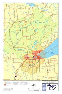 St. Louis River and Bay AOC Boundary MapThe St. Louis River drains 3,634 square miles and enters the southwest corner of Lake Superior between Duluth, Minnesota, and Superior, Wisconsin. It became an Area of Concern on the Great Lakes under the Great Lakes Water Quality Agreement of 1987.
The area was considered highly degraded because of:
- historical discharges
- Superfund sites
- high levels of contamination in river sediments
- the bay receiving wastewater discharge from the local sanitation facility
- landfill sites and other point-source dischargers have also contributed to the contamination
The Area of Concern includes:
- The Interlake and U.S. Steel Superfund sites
- Newton Creek
- Hog Island Inlet
Beneficial Use Impairments
- Restrictions on fish and wildlife consumption
- Excessive loading of sediment and nutrients
- Degradation of fish and wildlife populations
- Beach closings
- Fish tumors or other deformities
- Degradation of aesthetics - REMOVED 2014
- Degradation of benthos
- Loss of fish and wildlife habitat
- Delisting targets
In 1987, the St. Louis River and Bay was declared an Area of Concern and in 1992 a Remedial Action Plan Stage I document was completed.