About Sheboygan River AOC
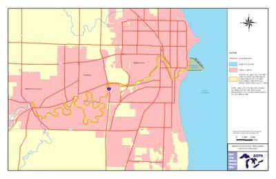 Sheboygan River AOC Boundary MapThe Sheboygan River Area of Concern encompasses the lower Sheboygan River downstream from the Sheboygan Falls Dam, including the entire harbor and nearshore waters of Lake Michigan. The AOC serves as a sink for pollutants carried from three watersheds: the Sheboygan River, Mullet River and Onion River.
Sources of Pollution
The 1989 remedial action plan identified several contaminants in the AOC including PCBs, PAHs, heavy metals, fecal coliform bacteria, and excessive amounts of phosphorus and nitrogen. The pollutants came from a range of sources:
- Rural and urban nonpoint sources (over 50 percent)
- Unregulated discharges from industrial facilities
- Sewage treatment plants
- Spills, illegal dumping and improper disposal of household hazardous waste
Beneficial Use Impairments
- Restrictions on fish and wildlife consumption
- Eutrophication or undesirable algae
- Degradation of fish and wildlife populations
- Fish tumors or other deformities
- Bird or animal deformities or reproduction problems
- Degradation of benthos
- Degradation of phytoplankton and zooplankton populations
- Restriction on dredging activities -Removed 2015
- Loss of fish and wildlife habitat