About Rouge River AOC
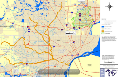 Boundary map of the Rouge River AOC
The Rouge River watershed is in southeastern Michigan. It was named an Area of Concern on the Great Lakes under the Great Lakes Water Quality Agreement of 1987.
The Rouge River has four main branches totaling 125 miles of waterways that primarily flow through Wayne and Oakland counties, with some headwaters in Washtenaw County. The lower four miles of the river are maintained as a shipping channel from the turning basin to the river's mouth at the south end of Zug Island.
The Rouge River watershed contains the oldest and most heavily populated and industrialized area in southeast Michigan. Degradation of the Rouge River is representative of that found in many urbanized and industrialized areas within the Great Lakes Basin.
- Over 50% of the land use is residential, commercial, or industrial, with increasing development pressures in the headwaters.
- Over 50 miles of publicly-owned parklands in the northern and western portions of the watershed are adjacent to watercourses
- Land uses include rural, suburban, urbanized and industrial
Sources of pollution
- Municipal and industrial direct dischargers
- Combined and separate sewer overflows
- Nonpoint source pollution/storm runoff
- heavy metals
- PCBs
- polycyclic aromatic hydrocarbons (PAHs)
- oil and grease
Beneficial Use Impairments
- Restrictions on fish and wildlife consumption
- Eutrophication or undesirable algae
- Degradation of fish and wildlife populations
- Beach closings
- Fish tumors or other deformities
- Degradation of aesthetics
- Degradation of benthos
- Restriction on dredging activities
- Loss of fish and wildlife habitat
In 1987, Rouge River was declared an Area of Concern. The first Remedial Action Plan document was completed in 1989.