About Rochester Embayment AOC
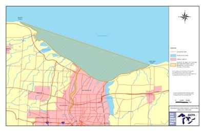 Rochester Embayment AOC Boundary Map The Rochester Embayment is formed by the indentation of the Monroe County, NY, shoreline between Bogus Point in the town of Parma and Nine Mile Point in the town of Webster. The northern boundary of the embayment is delineated by the straight line between these two points. The southern boundary includes approximately 6 miles of the Genesee River that is influenced by lake levels, from the river's mouth to the Lower Falls. The drainage area of the embayment totals more than 3,000 square miles. This area consists of the entire Genesee River Basin and parts of two other drainage basins, the easternmost area of the Lake Ontario West Basin and the westernmost part of the Lake Ontario Central Basin.
The former 3M/Dynacolor Plant and former G.E. and Black & Decker Site in Brockport, NY, were manufacturing facilities used by many companies prior to the early 1950s. The sites have been indicated as sources of PCBs, SVOCs, cyanide and metals found in an unnamed tributary of Brockport Creek, which is a tributary of the Salmon Creek watershed in the western embayment. Mirex, dioxins and furans have all been found in the AOC.
Beneficial Use Impairments
- Restrictions on fish and wildlife consumption
- Tainting of fish and wildlife flavor
- Fish tumors or other deformities
- Eutrophication or undesirable algae
- Restrictions on drinking water consumption, or taste and odor – REMOVED 2010
- Degradation of fish and wildlife populations
- Beach closings
- Degradation of aesthetics
- Bird or animal deformities or reproduction problems
- Added costs to agriculture or industry – REMOVED 2011
- Degradation of benthos
- Degradation of phytoplankton and zooplankton populations
- Restriction on dredging activities
- Loss of fish and wildlife habitat