About River Raisin AOC
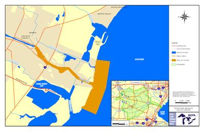 River Raisin AOC Boundary Map The River Raisin Area of Concern is located in the southeast portion of Michigan's lower peninsula in Monroe County. The AOC is defined as the lower 2.6 mile portion of River Raisin, downstream from the low head dam at Winchester Bridge in the City of Monroe, extending one-half mile out into Lake Erie following the Federal Navigation Channel and along the north and south nearshore zones of Lake Erie.
Sources of Pollution
- Wastewater treatment plant
- Power plants, stamp plants and other facilities
- Agriculture
- Local landfills
PCBs and heavy metals are primary contaminants of concern. Copper, zinc and chromium contribute the most metallic pollution.
Beneficial Use Impairments
- Restrictions on fish and wildlife consumption
- Eutrophication or undesirable algae – REMOVED 2013
- Degradation of fish and wildlife populations
- Beach closings – REMOVED 2013
- Degradation of aesthetics – REMOVED 2012
- Bird or animal deformities or reproduction problems
- Degradation of benthos
- Restriction on dredging activities
- Loss of fish and wildlife habitat