Cove, Arizona Mines Cleanup
In 2014, the United States entered into a historic legal settlement that will provide almost $1 billion to investigate and clean up approximately 50 uranium mines on or near the Navajo Nation that were operated by Kerr-McGee Corporation and its successor, Tronox. Approximately 32 of these mines are in the Cove/Lukachukai area.

Site Description and History
Cove was named for its remote location in the foothills of the Chuska mountain range, tucked away in the Carrizo, Lukachukai and the beautiful mountains in northeastern Arizona, in the Northern Agency of the Navajo Nation. Local industries include farming, traditional gathering activities, grazing livestock, and hunting, but most residents work outside the community. Culturally significant areas, including ceremonial spaces, and geologic features such as mesas, overhangs, and caves, characterize the landscape setting and rich natural resources.
From the late 1940s to the 1980s, Kerr-McGee Corporation mined more than seven million tons of uranium ore on or near the Navajo Nation. About 32 of these mines are located in the Cove. The area being assessed by EPA includes the abandoned uranium mines (AUMs) within the Cove Chapter boundary and the resulting contaminated areas. This area includes 50 AUMs within Cove Wash watershed.
- Current investigations
Investigations into the extent of mine impacts were implemented as soon as settlement funds were received in January 2015. There are approximately 24 additional abandoned uranium mines in the Lukachukai Mountains that are not covered by the settlement because they were not operated by Kerr-McGee. EPA is working to identify additional responsible parties to pay for cleanup of these mines.
EPA is conducting several investigations within the Cove site to include a watershed assessment, a mine category assessment protocol (MCAP), aerial radiological surveys (ASPECT) and an irrigation system and farm plot study.
- Cove Wash Watershed Assessment
The Cove Wash watershed is approximately 47 square miles, and contains approximately 52 miles of tributaries. The watershed supports diverse wildlife and plant communities, including perennial wetland habitats, and is home to protected species such as Mexican spotted owl and American dipper. Livestock grazing activities move seasonally between the lowlands and steep, mountainous areas.
The Cove Wash watershed is not currently a designated drinking water source, but may have been historically used by residents before drinking water was provided by a municipal source 20 years ago. Resident farmers also use these streams for crop irrigation and livestock watering. Wells sampled in the past have shown exceedances in drinking water standards for Total uranium, and have been decommissioned for domestic use.
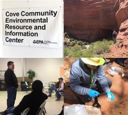
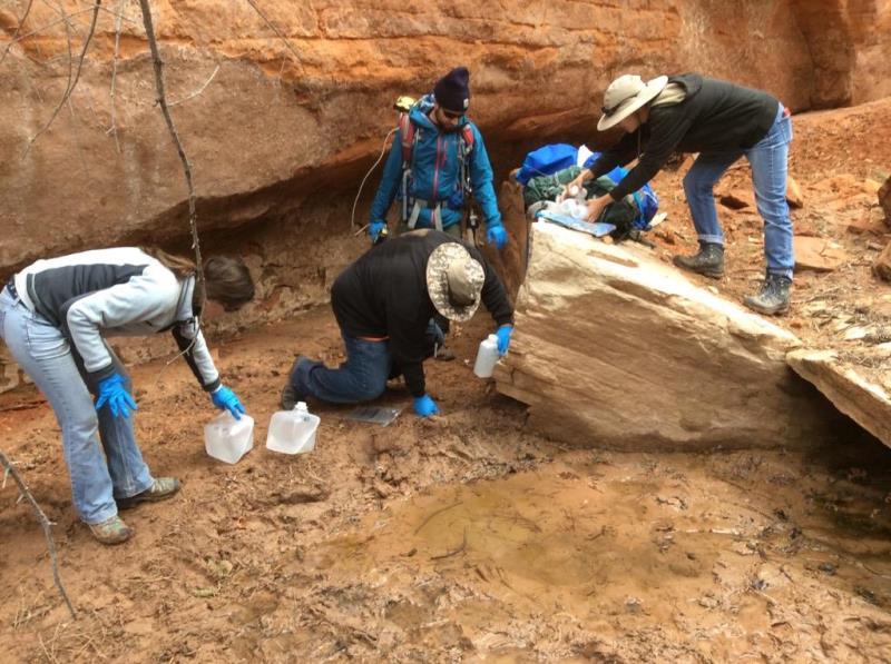
The watershed assessment includes sampling surface water, seeps, springs, wells, and sediment throughout the watershed over the course of several years and several seasonal conditions. Sampling is used to pinpoint contaminated areas and to understand baseline conditions prior to waste removal actions. The assessment also includes biological surveys, and inventories of plants and herbs important for traditional or ceremonial uses.
- Mine Category Assessment Protocol
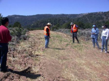
The purpose of the mine category assessment protocol (MCAP) is to develop and implement a systematic method for assessing and surveying AUM sites to determine and evaluate removal factors impacting future site work. MCAP will result in a ranking system for prioritizing Removal Site Evaluations in upcoming years.
- Airborne Spectral and Photometric Environmental Collection Technology (ASPECT)
The USEPA sent a team to perform an aerial radiation and imagery survey of the Navajo Nation abandoned uranium mines in the Cove Chapter area. This area includes the Lukachukai Mountains, containing the Kerr McGee/Tronox associated mine sites as well as the drainages and flat lands north of the mountains, extending past the Cove Chapter house. The survey was performed by a white low-flying USEPA airplane with twin engine propellers during one week in December 2014. The purpose of this survey was to identify potential additional radiation coming from the dozens of old mines scattered over many miles around the Cove Chapter area. The survey will also assist EPA and Navajo Nation (NNEPA) prioritize areas for additional environmental assessment activities that will be used to determine if these sites pose a risk to people in the area and, if so, what measures should be taken to minimize that risk.
- Irrigation System and Farm Plot Study
Based on community concerns, EPA will investigate whether active and historic irrigation systems (irrigation canals and storage ponds) and farm fields may be impacted by mines, and whether there may be associated human health risks through ingestion of agricultural crops that are grown in sampled areas using irrigation system and Cove Wash surface water.
Community Involvement
- Who is the community?
The community of Cove is located in a remote area surrounded by the Lukachukai and Carrizo Mountains on the Navajo Nation. According to the 2010 U.S. Census there are 430 people that live in the community. Many of the community family members have worked in the mines located on the Lukachukai mountains. Community concerns include AUMs, air and water, future land use, health, workforce development.
- EPA Current Community Involvement Activities
EPA works with Cove chapter officials as well as community members for all outreach activities and information sessions. All activities are culturally sensitive and are designed to keep the community well informed and engaged. To keep the community informed, EPA has done the following:
- The Cove team is developing a grant with Dine’ College and a cooperative agreement with the Cove Chapter so that the local residents can be more in involved the work EPA is doing.
- A Community Involvement Plan (CIP) is in progress and scheduled to be completed in FY16.
- A Cove Community Environmental Resource and Information Center was established, providing factsheets, maps, educational and health related materials to AUMs, the Five-Year Plan, etc.
- A Community Liaison has been hired with the assistance of TASC. The liaison is from Cove and provides door-to-door outreach related EPA activities in Cove.
- EPA works closely with the Cove Chapter Manager and officials to obtain access agreements so EPA can sample farm irrigation water.
- EPA Past Community Involvement Activities
EPA completed the following activities in the community:
- A Mine Category Assessment Protocal (MCAP) was completed in May of 2016.
- Developed signs identifying water wells that are not safe to drink (signs are currently under review by the community).
- We have held community information sessions consistently at the request of local elected officials regarding all EPA activities.
- Provided Hazardous Waste Operations and Emergency Response Standard (HAZWOPER) training.
- Developed factsheets on ASPECT Flyover, Tronox Settlement, HAZWOPER training, Sampling and Internships, Sampling Results, Signage and Water Poster and maps specific to Cove.
- Partnerships
EPA conducts its work in close coordination with the Cove community, Navajo agencies and educational institutions, as well as other federal agencies. Partnering activities include developing cooperative agreements and interagency agreements for support to EPA. Examples include:
- Strategic planning and implementation of priority activities in consultation with Navajo Nation EPA
- Engaging local expertise, such as educator and researchers from Dine’ College for technical and cultural sensitivity matters, and Navajo Abandoned Mine Lands Reclamation Department (Shiprock) for technical expertise
- Providing internship opportunities for students at Dine College, Navajo Technical University, University of New Mexico, Northern Arizona University, and others
- Prioritizing and coordinating actions with the Cove Chapter and local residents
- Developing new technical approaches with USGS and Navajo Nation EPA Water Quality
 Tronox Area Mines Lukachukai Mountains | Click image for a larger map
Site Facts
- Area is ~47 square miles
- Contains ~52 miles of tributaries
- ~32 of the 50 Tronox AUM are in the Cove/Lukachukai area
- ~24 additional AUM not covered by Tronox
Site Documents
Site Contacts
Remedial Project Manager
Chip Poalinelli (poalinelli.edwin@epa.gov)
(415) 972-3390
Remedial Project Manager
Gaelle Glickfield (glickfield.gaelle@epa.gov)
(415) 972-3045
Environmental Protection Specialist
Secody Hubbard (hubbard.secody@epa.gov)
(415) 972-3241
Cleanup Progress Timeline
Mining began in Cove in 1949, but ceased by the late 1960s. Reclamation efforts began in the early 1990s. There are a total of 50 AUMs in the Cove Wash watershed. There are 26 of the 50 former Kerr-McGee mines listed in the Tronox settlement located in Cove. Click on the different years below to learn about recent and upcoming activities.
 AML performs reclamation activities on 201 of 232 mine features and waste areas in Cove.
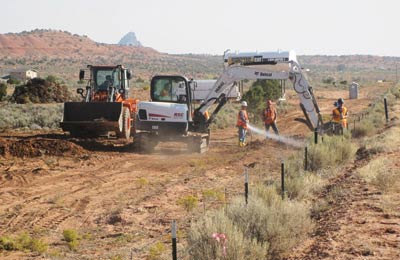 EPA performs a removal action at Cove Transfer Stations 1 and 2.
 ASPECT aircraft flies over Cove and obtains radiological signature data and aerial photographs, December.
- Kerr-McGee settlement funding (close to $1 billion) available to EPA for 32 of the Cove mines and the environmental areas they affect.
- Watershed study sampling round 1, June.
 Watershed study sampling round 2, March and sampling round 3, August.
- Mine Category Assessment Protocol fieldwork to prioritize mines for removal site evaluations, March and April.
- Dam and irrigation study field work activities and sampling, June.
- Groundwater investigation initiated.
- Additional work at Transfer Station 1 to stabilize front yard slope, June.
- Biological surveys for Mexican Spotted Owl and plant species, spring and summer.
- Signs placed on non-regulated water sources, May.
- Removal site evaluations at prioritized mine areas.
- Groundwater investigation continues.
- Biological surveys for Mexican Spotted Owl and plant species, spring and summer.
- Biological survey of the Cove Wash habitat, summer.
- Air monitoring commences, spring.
- Evaluate technologies that could be used for response actions (e.g. removal strategies and repository locations).
- Removal actions at prioritized mine sites commence in the spring.
- Air monitoring continues.
- Evaluate permanent solutions and locations for mine waste.
- Decisions about permanent solutions and locations for mine waste will be presented to the public and decision documents signed.
- Initiate design process for permanent solutions/remedial actions.