About Muskegon Lake AOC
 Muskegon Lake AOC Boundary Map
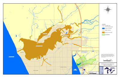
Muskegon Lake is a 4,149 acre inland coastal lake in Muskegon County, Michigan along the east shoreline of Lake Michigan. The Muskegon Lake AOC includes the entire lake; the lake is separated from Lake Michigan by sand dunes. The Muskegon River flows through the lake before emptying into Lake Michigan. Additional tributaries include Mosquito Creek, Ryerson Creek, Ruddiman Creek, Green Creek, and Four Mile Creek.
The immediate inland area is primarily residential and industrial, with chemical and petrochemical companies, foundries, a pulp and paper mill, and other industries located on the lake or within its immediate watershed.
In 1985 Muskegon Lake was designated an AOC because of:
- water quality and habitat problems associated with the historical discharge of pollutants into the AOC
- high levels of nutrients, solids, and toxics entering the lake had caused a series of problems including
- nuisance algal blooms
- reduced oxygen in the lake's deeper water
- tainted taste of fish due to petroleum products in the water
- contaminated sediments
- the degradation of benthos (bottom-dwelling organisms, also referred to as the benthic community), the contamination of fish, and the reduction in fish and wildlife habitat.
- localized groundwater contamination that was moving toward the lake and its tributaries.
Beneficial Use Impairments
- Beach closings
- Restrictions on fish and wildlife consumption
- Eutrophication or undesirable algae
- Restrictions on drinking water consumption, or taste and odor
- Degradation of fish and wildlife populations
- Degradation of aesthetics
- Degradation of benthos
- Restrictions on dredging activities
- Loss of fish and wildlife habitat