About Menominee River AOC
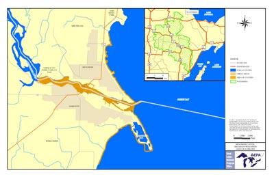 Printable boundary map and shapefile of Menominee River AOCThe Menominee River forms the boundary between the northeast corner of Wisconsin and the southern tip of the upper peninsula of Michigan. The river's headwaters originate in both states. The main stem of the river flows between the cities of Menominee, Michigan and Marinette before emptying into Green Bay.
A primary cause of the identified use impairments below Menominee Dam is arsenic contamination in the turning basin and in sediments along the right bank (downstream direction) of the river below the Tyco Fire Products LP (former Ansul Fire Protection Company) property, an herbicide production facility in Marinette, Wisconsin. This problem was caused from improper arsenic storage and disposal practices by Ansul from 1957 to 1977.
- The lower three miles of the river from the Park Mill Dam to the river's mouth and approximately 3.1 miles north and south of the mouth along the adjacent shoreline of Green Bay
- City of Marinette
- City of Menominee
- The adjacent nearshore area of Green Bay, Wisconsin
- WPSC Marinette Manufactured Gas Plant “Coal Tar Site”
- Chemical and ship building companies
- Two paper mills
- Two municipal wastewater treatment plants
- A foundry
- Runoff from stormwater and storage piles of salt, coal, and other materials
Beneficial Use Impairments
- Restrictions on fish and wildlife consumption
- Degradation of fish and wildlife populations
- Degradation of benthos
- Restriction on dredging activities
- Loss of fish and wildlife habitat
- Beach closings – REMOVED 2011