About Maumee River AOC
Agriculture runoff was causing large amounts of phosphorus to enter the Maumee River, ultimately leading to cultural eutrophication in Lake Erie. Excessive amounts of nitrate and sediment also caused further pollution. Further investigation revealed there were other contaminents of concern including PCBs, heavy metals, phthalates and polycyclic aromatic hydrocarbons (PAHs) from different sources such as:
- Old dumps
- Contaminated industrial sites
- Combined sewer overflows
- Disposal of dredged materials
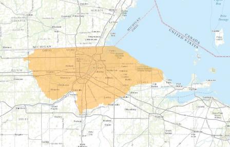
The Maumee AOC covers 775 square miles and has been extended over the years to include several creeks. The Maumee River begins in Ft. Wayne, Indiana and travels more than 130 river miles to Lake Erie. 105 miles of the river are in Ohio. At 8,316 square miles, the Maumee has the largest drainage area of any Great Lakes river.
Beneficial Use Impairments
- Restrictions on fish and wildlife consumption
- Eutrophication or undesirable algae
- Degradation of fish and wildlife populations
- Beach closings
- Fish tumors or other deformities
- Degradation of aesthetics
- Degradation of benthos
- Restriction on dredging activities
- Loss of fish and wildlife habitat