About Kalamazoo River AOC
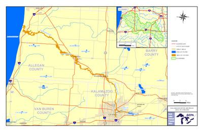 Kalamazoo River AOC Boundary Map
The Kalamazoo River drains an extensive watershed in the southwest portion of the lower peninsula of Michigan. The river flows in a westerly direction and discharges into Lake Michigan near the town of Saugatuck. The upstream boundary of the Area of Concern is Morrow Dam and the AOC extends downstream to Lake Michigan; a distance of approximately 80 miles. The city of Kalamazoo is situated along the AOC reach and the city of Battle Creek is a short distance upstream.
The Kalamazoo River was listed as an AOC due to historic releases of PCBs, which originated primarily from de-inking operations at local paper mills. The Kalamazoo River has been identified as a site of environmental contamination pursuant to the Michigan Natural Resources and Environmental Protection Act 451 and is included in Superfund.
Beneficial Use Impairments
- Restrictions on fish and wildlife consumption
- Degradation of fish and wildlife populations
- Beach closings – REMOVED 2011
- Degradation of aesthetics – REMOVED 2012
- Bird or animal deformities or reproduction problems
- Degradation of benthos
- Restriction on dredging activities
- Loss of fish and wildlife habitat