Envirofacts Model
- Home
- Multisystem Search
- Topic Searches
- System Data Searches
- About the Data
- Data Downloads
- Widgets
- Services
- Mobile
- Other Datasets
Use this graphical image to access detailed descriptions (metadata) of the available databases in the Envirofacts Warehouse. Click on a system name to access the available model and metadata for a database. Click on a system description to access the system overview.
Click on the system name to view the available data model.
Click here for narrative description of the flow chart.
Envirofacts has developed a RESTful data service API to all of its internal data holdings. This functionality provides a user of Envirofacts with the ability to query any table, available in the Envirofacts database model, through the use of a URL. For more information on the RESTful data service API, please visit the Services page.
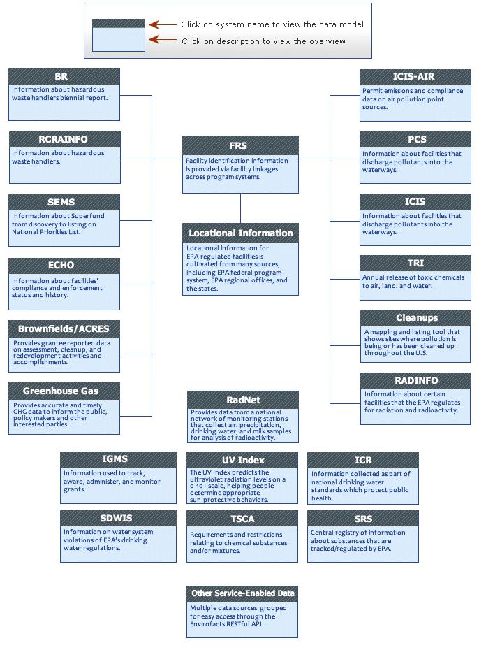
The following systems link to FRS:
BR Overview | BR Model
The Biennial Report is a national system that collects data on the generation, management, and minimization of hazardous waste.
Brownfields/ACRES Overview
Provides grantee reported data on assessment, cleanup, and redevelopment activities and accomplishments.
SEMS Overivew | SEMS Model
The Comprehensive Environmental Response, Compensation, and Liability Information System provides information about Superfund (cleaning/removal of hazardous waste) sites, from discovery to their listing on the National Priorities list.
Cleanups Overview
Cleanups in My Community is a mapping and listing tool that shows sites where pollution is being or has been cleaned up throughout the U.S.
ECHO Overview
Enforcement and Compliance History Online provides information about facilities' compliance and enforcement status and history.
FRS Overview | FRS Model
The Facility Registry Service provides facility identification information via facility linkages across several program systems.
GHG Overview | GHG Model
The program requires annual reporting of greenhouse gas (GHG) data and other relevant information from large direct emissions sources and suppliers of certain fossil fuels and industrial gases in the United States.
ICIS-AIR Overview | ICIS-AIR Model
ICIS-AIR provides permit emissions and compliance data on air pollution point sources.
Locational Information Overview | LRT Model
Locational information for EPA-regulated facilities in Envirofacts is cultivated from many sources, including EPA federal program systems, EPA regional offices, and the states.
PCS Overview | PCS Model
The Permit Compliance System provides information about facilities that discharge pollutants into the waterways.
RADInfo Overview | RADInfo Model
The Radiation Information Database provides information aobut certain facilities that EPA regulates for radiation and radioactivity.
RCRAInfo Overview | RCRAInfo Model
Resource Conservation and Recovery Act Information provides information about nationwide hazardous waste handlers.
TRI Overview | TRI Model
Toxics Release Inventory contains information about the annual release of toxic chemicals to the air, land, and water.
The remaining program systems in Envirofacts do not link to FRS:
IGMS Overview | IGMS Model
Integrated Grants Management System provides information used to track, award, administer, and monitor grants.
ICR Overview | ICR Model
Information Collection Rule has information that was collected as part of national drinking water standards which protect public health.
RadNet Overview | RadNet Model
Formerly, Environmental Radiation Ambient Monitoring System (ERAMS), provides data from a national network of monitoring stations that collect air, precipitation, drinking water, and milk samples for analysis of radioactivity.
SDWIS Overview | SDWIS Model
Safe Drinking Water Information System provides information on water system violations of EPA's drinking water regulations.
SRS Overview
Substance Registry Services is a central registry of information about substances that are tracked/regulated by EPA.
TSCA Overview
Provides information about chemical substances and/or mixtures that are regulated by the Toxic Substances Control Act.
UV Index Overview
The UV Index predicts the ultraviolet radiation levels on a 0-10+ scale, helping people determine appropriate sun-protective behaviors.
Other Service-Related Data:
Design for the Environment