AgSTAR National Mapping Tool
What is the National Mapping Tool?
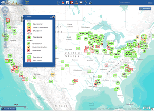 Launch the National Mapping Tool. (Remember to right click on the link and choose "Open link in new window" to view the tool and this page at the same time.)
The National Mapping Tool helps advance the use of anaerobic digestion in the agriculture sector in the United States. The National Mapping Tool helps you:
- Locate anaerobic digesters using livestock waste,
- Examine the potential for growth in the agriculture sector,
- Identify and compare investments,
- Find organizations related to the AgSTAR program, and
- Compare state incentives, policies, standards and emissions.
Getting Started (Frequent Questions)
- Why don’t I see anything when I check a data layer box?
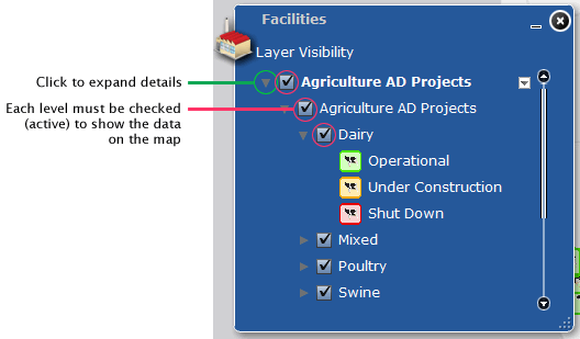
Additional selections need to be made. Click on the triangle icon to the left of the data layer of interest, which will expand the list to show more options. Each “check” activates the selection, and each level must be checked (activated) to display data on the screen. The image below provides an example.
- Does unchecking a box at a higher level but keeping the sub-level boxes checked mean that the sub-level selections are still active?
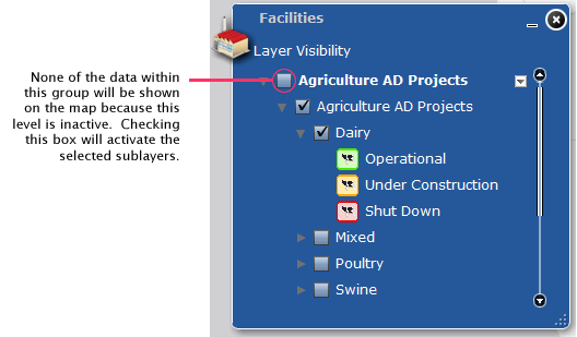
No. By unchecking a higher level box, the layer is turned off regardless of whether sub-level selections are still checked. If the higher level box is not checked, then nothing will appear for sub-level boxes.
- Can I make the windows bigger? Some of the content seems to be cut off.
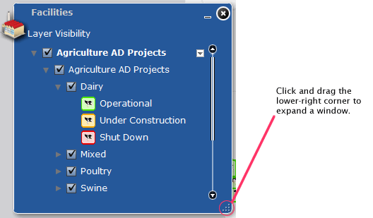
You can adjust the size of a window by clicking on the lower right-hand corner and moving the mouse.
- For layers that shade portions of the map, (e.g., the “Growth Potential” layers), only one layer is displayed when multiple layers are selected. Why aren’t the other selected layers showing up?
For layers that shade the states on the map, only one selection can be viewed at one time. By clicking on the drop-down menu to the right of the layer title, users can “Move Up” or “Move Down” the order that selected layers are viewed. Additionally, in the “Tools” menu, the “Swipe and Spotlight” tool will allow users to see multiple selections by movement of the mouse.
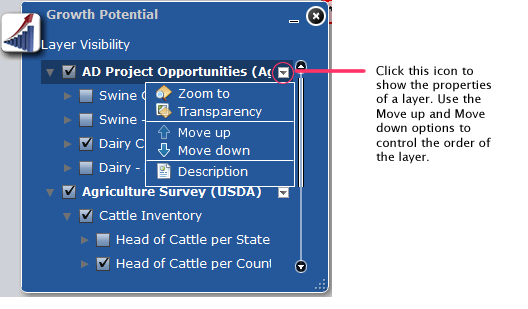
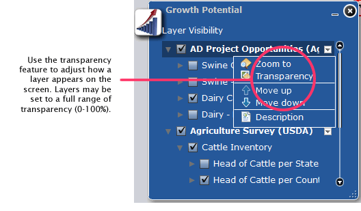
- I have multiple layers selected and showing. Is there a way to make certain layers less visible?
Yes, by clicking on the drop-down menu to the right of the layer title and clicking on “Transparency,” a user can adjust the transparency of the layer on the map.
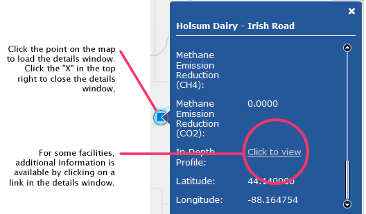
- How do I view information for individual facilities that I see displayed on the map?
Facility details can be viewed by clicking on the icon on the map. A pop-up window will display the available details for that facility. In some cases, a hyperlink is provided to view additional details for a facility.
- There is missing information or the information posted is outdated. Is there a way to provide an update to EPA?
Yes! Please contact us with updates and corrections.
About the Data
The Mapping Tool allows you to customize your research using different types of data—known as data layers. Brief descriptions of the data layers available in the mapping tool include: facilities, growth potential, state summaries, investments and related organizations.
- Anaerobic Digesters
The AgSTAR Anaerobic Digester Database supplies the data for the mapping tool’s anaerobic digesters at livestock farms in the United States. The mapping tool includes facilities that are under construction, operating, or shut down. Details on each facility are available by clicking on a map symbol. In-depth profiles are available for select projects. - Landfill Gas Energy Projects
EPA’s Landfill Methane Outreach Program is the data source for operational landfill gas projects in the United States. Landfill gas can be used for many purposes, including heating greenhouses, producing electricity and heat in cogeneration applications, and providing fuel to chemical and automobile manufacturing. - Wastewater Treatment Plants
The Water Environment Federation Exit is the data source for wastewater treatment facilities, many of which operate anaerobic digesters to generate energy from biogas and to control greenhouse gas emissions. Biogas from these digesters can be used as fuel to generate electricity and heat for the facility. - Waste Facilities
The Waste Business Journal Exit provides data for nearly 9,000 waste facilities in the mapping tool. Details for each facility include the types of wastes or materials that are accepted, volume of primary waste, cost per ton, tipping fees and remaining capacity. - Composting Facilities
EPA and the Waste Business Journal provide data on composting facilities, which divert organic wastes away from traditional landfills. The mapping tool includes details for operating and pilot composting facilities across the United States, including the annual tonnage and number of households served by each. The map organizes facilities by the types of waste received.
- The Market Opportunities Report is used to represent the number of candidate farms and biogas energy generation potential by state for hog and dairy operations.
- Inventory of Livestock Survey (USDA, 2007) provides state and county level data for livestock operations and the number of cattle, poultry and hogs.
- EPA’s Inventory of U.S. Greenhouse Gas Emissions and Sinks: 1990-2014 provides state-level summaries of methane emissions for livestock operations by animal group, including beef, dairy, poultry, swine, sheep, goats, horses, mules and asses, and bison.
- The Database of State Incentives for Renewable Energy (DSIRE) Exit is the data source for:
- Renewable Portfolio Standards (RPS): A state’s RPS requires retail electric providers to supply a specified minimum amount of customer load with electricity from eligible renewable energy sources.
- State Incentives for Renewable Energy: including incentives and policies established by the federal government, state governments and U.S. territories, local governments, and larger electric and gas utilities in the United States.
- State-level Investments in Renewable Energy Projects: including information on USDA programs that provide assistance to renewable energy and energy efficiency projects.
- USDA programs that provide assistance to renewable energy and energy efficiency projects are represented in the mapping tool. Energy investments are categorized by energy type, including anaerobic digester. Investments are also shown by funding program.
- AgSTAR’s partners across the country, including state agencies, agricultural extension offices, universities and other state-wide non-governmental organizations are represented in the mapping tool. Additionally, colleges and universities that conduct research related to anaerobic digesters are also included.
