NPDES Permits in New England
Regulated MS4 in Massachusetts
You will need Adobe Reader to view some of the files on this page. See EPA's PDF page to learn more about PDF, and for a link to the free Acrobat Reader.
Massachusetts Phase II Automatically Designated Area (PDF) (1 pg, 2.1 MB)
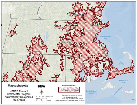
All MS4s operated within the regulated area are subject to the Phase II MS4 Program
Visit MassDEP's website to search surface water quality maps related to 305(b)/303(d) waters in Massachusetts.
Traditional MS4s
Community-Specific Information
Click On:
- "Regulated Area Map" to view a community-specific map showing the geographic extent of draft permit coverage according to Urbanized Area delineated by the 2010 Census
- "IC Map" to view a community-specific map showing the geographic extent of permit coverage and impervious area (IA) in PDF format
- "IC Stats" to view community-specific statistics of impervious area (IA) and Directly Connected Impervious Area (DCIA) in Excel format
- "NOI" to view an Operator's NOI (once available) in PDF format
- "Reports" to view an Operator's annual reports (once available) in PDF format
* Information in grey-scale not yet available
- Comprehensive IC Statistics (Excel) (14.8 MB)
View a comprehensive list of impervious area (IA) and Directly Connected Impervious Area (DCIA) statistics for all regulated communities
Non-Traditional MS4s
|
|
|
|
You may also request copies of these documents by contacting Glenda Velez (velez.glenda@epa.gov or 617.918.1677).