About Waukegan Harbor AOC
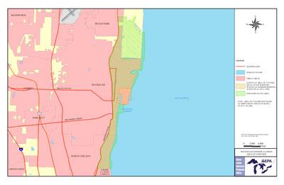 Boundary map of Waukegan Harbor AOC
The Waukegan Harbor AOC is in Lake County, Illinois, on the western shore of Lake Michigan. An Expanded Study Area (ESA) was added to explore additional concerns of the citizens beyond the AOC. The ESA is bounded by:
- Dead River to the north
- A bluff line parallel to Sheridan Road to the west
- The southern boundary of the former U.S. Steel property to the south
- The nearshore waters of Lake Michigan to the east.
A natural inlet and portions of adjacent wetlands were filled to form the present shape of the harbor. Waukegan Harbor consists of approximately 1.2 square kilometers of industrial, commercial, municipal and open/vacant lands.
In 1975, polychlorinated biphenyls (PCBs) were discovered in Waukegan Harbor sediments. Bioaccumulation of PCBs found in the heavily contaminated harbor sediments lead to contamination of fish in Waukegan Harbor.
Beneficial Use Impairments
- Restrictions on fish and wildlife consumption
- Degradation of phytoplankton and zooplankton populations
- Degradation of benthos
- Beach closings – Removed 2011
- Loss of fish and wildlife habitat – Removed 2013
- Restriction on dredging activities– Removed 2014