NHDPlusV1 Pacific Northwest Data
You may need additional software to view some of the links on this page. See EPA’s Free Viewers and Readers page. The links will vary in file size
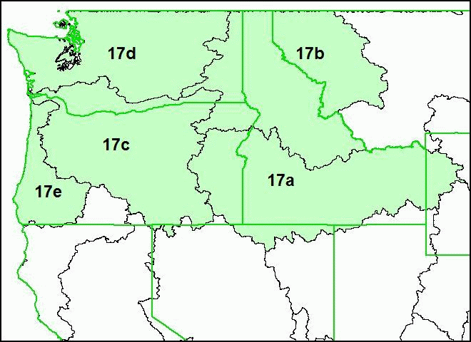
Pacific Northwest (Hydrologic Region 17)
The Pacific Northwest drainage area is composed of hydrologic region 17.
The Pacific Northwest hydrologic regions are further divided into production units: 17 a, b, c, d, and e.
NHDPlus Shapefile and DBF components are distributed by hydrologic region.
NHDPlus ESRI Grid components are distributed by production units.
For more information please see Pacific Northwest Release Notes (DOC)(4 pp, 38 K) or Pacific Northwest Release Notes (PDF)(4 pp, 23 K, About PDF).
The following links exit the site Exit
FILENAME KEY
NHDPlusrrVnn_componentname.zip
where:
- rr is the hydrologic region number
- nn is the currently available version of the data
- componentname describes the content of the zip file
| File Description | File Name (.zip) | Format |
|---|---|---|
| Region 17, Version 01_02, Elevation Unit a | NHDPlus17V01_02_elev_unit_a | ESRI Grid |
| Region 17, Version 01_02, Elevation Unit b | NHDPlus17V01_02_elev_unit_b | ESRI Grid |
| Region 17, Version 01_02, Elevation Unit c | NHDPlus17V01_02_elev_unit_c | ESRI Grid |
| Region 17, Version 01_02, Elevation Unit d | NHDPlus17V01_02_elev_unit_d | ESRI Grid |
| Region 17, Version 01_02, Elevation Unit e | NHDPlus17V01_02_elev_unit_e | ESRI Grid |
| Region 17, Version 01_02, Flow Accumulation and Flow Direction Unit a | NHDPlus17V01_02_fac_fdr_Unit_a | ESRI Grid |
| Region 17, Version 01_02, Flow Accumulation and Flow Direction Unit b | NHDPlus17V01_02_fac_fdr_Unit_b | ESRI Grid |
| Region 17, Version 01_02, Flow Accumulation and Flow Direction Unit c | NHDPlus17V01_02_fac_fdr_Unit_c | ESRI Grid |
| Region 17, Version 01_02, Flow Accumulation and Flow Direction Unit d | NHDPlus17V01_02_fac_fdr_Unit_d | ESRI Grid |
| Region 17, Version 01_02, Flow Accumulation and Flow Direction Unit e | NHDPlus17V01_02_fac_fdr_Unit_e | ESRI Grid |
| Region 17, Version 01_04, Catchment Flowline Attributes | NHDPlus17V01_04_Cat_Flowline_Attr | DBF |
| Region 17 , Version 01_02, Catchment Grid | NHDPlus17V01_02_Catgrid | ESRI Grid |
| Region 17, Version 01_02, Catchment Shapefile | NHDPlus17V01_02_Catshape | Shapefile |
| Region 17, Version 01_02, National Hydrography Dataset | NHDPlus17V01_03_NHD | Shapefile and DBF |
| Region 17, Version 01_02, QAQC & Sinks Spreadsheet | NHDPlus17V01_02_QAQC_Sinks | Excel Spreadsheet |
| Region 17, Version 01_01, Stream Gage Event | NHDPlus17V01_01_StreamGageEvent | DBF |