Superfund Sites in Reuse in New Hampshire
If you are having trouble viewing the map in your browser, click the 'View larger map' link below
Auburn Road Landfill
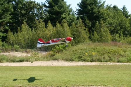 Auburn Road LandfillThe 200-acre Auburn Road Landfill Superfund site, located in Londonderry, New Hampshire, includes three separate disposal areas that total about 12 acres. The site operated from the 1960s until 1980 as a disposal area for chemical wastes, tires, demolition debris and solid waste. The State of New Hampshire found contamination in soil, groundwater and surface water and ordered the landfill to close in 1980. EPA placed the site on the Superfund program’s National Priorities List (NPL) in 1983. Cleanup activities included capping and fencing of contaminated areas, and extension of the public water supply to nearby residents. Groundwater sampling is ongoing. Cleanup activities continue at the site. Parts of the site allow for recreational use as a model airplane flying field. The flying field opened in 2008. Reuse resulted from collaboration between EPA, the New Hampshire Flying Tigers Academy of Model Aeronautics and the Town of Londonderry.
For more information:
Fletcher's Paint Works & Storage
For more information:
Ottati & Goss/Kingston Steel Drum
 Ottati & Goss/Kingston Steel DrumThe 35-acre Ottati & Goss/Kingston Steel Drum Superfund site is located in Kingston, New Hampshire. The site includes a 6-acre parcel, known as the Great Lakes Corporation area and a 1-acre parcel, known as the Ottati & Goss area. From the late 1950s through 1976, various owners performed drum reconditioning operations on the Great Lakes Corporation area. Runoff and seepage from the site into nearby surface water killed fish and aquatic vegetation. From 1978 through 1979, site operators processed waste at the Ottati & Goss area. Activities at the site contaminated soil, groundwater and surface water. After operations ceased in 1979, the New Hampshire Bureau of Solid Waste Management prohibited site operators from restarting operations and ordered the removal of thousands of deteriorating and leaking drums from the site. EPA placed the site on the Superfund program’s National Priorities List (NPL) in 1983. Initial cleanup activities included removal of leaking drums, as well as soil and debris. Cleanup also included excavation and treatment of soil and sediment; on-site treatment of soil using low-level heat to pull contamination from the soil, groundwater treatment and wetland restoration.
For more information:
Pease Air Force Base
Cleanup and redevelopment have transformed the Pease Air Force Base site near Portsmouth, New Hampshire from one of the most contaminated Superfund sites in New England to a wildlife refuge and public airport. From the 1950s until 1991, the U.S. Air Force (Air Force) used the 4,000-acre facility to maintain military aircraft. Aircraft maintenance operations contaminated soil and ground water with solvents and fuel, prompting EPA to add the site to the National Priorities List (NPL) in 1990. The Air Force has cleaned up the site and continues to treat and monitor ground water. In 1992, the Air Force transferred 1,702 acres of the site to the local government for use as a public airport and kept 229 acres for the New Hampshire Air National Guard. The New Hampshire Department of Transportation leased 20 acres for a highway expansion project. The Air Force also transferred 1,054 acres to the U.S. Fish and Wildlife Service (USFWS) for creation of the Great Bay National Wildlife Refuge. Then in 1997, USFWS received an additional 1,300 acres from the Air Force. Following the completion of cleanup activities in 2000, the Pease Development Association completed the Pease International Tradeport. The Pease International Tradeport currently includes about 250 businesses and provides employment to 7,000 people. In 2005, the Air Force transferred the remaining 268 acres of the site to the Pease Development Authority. Redevelopment of this area is ongoing.
For more information:
Somersworth Sanitary Landfill
The 26-acre Somersworth Sanitary Landfill Superfund site is located in Somersworth, New Hampshire. The City of Somersworth operated a waste disposal area at the site from the mid-1930s until 1981. Originally, the City burned residential, commercial and industrial wastes at the site. In 1958, the City stopped burning waste and converted the area into a landfill. Improper disposal practices contaminated site soil, sediment and groundwater. EPA added the site to the Superfund program’s National Priorities List (NPL) in 1983. Cleanup included a groundwater containment and treatment system, a porous landfill cover, gas venting, as well as land and groundwater use restrictions. Prior to the site’s placement on the NPL, the City covered a 10-acre portion of the site with clean fill for use as a recreational area. This on-site area includes a basketball court. An area of the site not developed as a part of the landfill remains a wetland area. In 2013, EPA presented the City with an initial assessment of renewable energy opportunities for the site. The City chose to move forward with plans for an on-site solar facility. In 2015, the City selected a team to develop the facility and started initial planning efforts.
For more information:
South Municipal Water Supply Well
The 250-acre South Municipal Water Supply Well Superfund site is located in the Contoocook River Valley in Peterborough, New Hampshire. Installed in 1952, the South Municipal Water Supply Well provided water to Peterborough for nearly 30 years. In 1982, the State of New Hampshire conducted routine testing of the water supply. Results showed contaminants in the South Well. Use of the well ended in 1982. Located west of the well, the New Hampshire Ball Bearings facility is the source of the contamination. The facility has manufactured precision ball bearings at this upgradient location since 1956. Activities at the New Hampshire Ball Bearings facility contaminated soil, groundwater, wetland sediments and surface water near the facility. EPA placed the site on the Superfund program’s National Priorities List (NPL) in 1984. Initial cleanup activities at the site included groundwater and soil treatment, off-site disposal of contaminated sediments, and wetland restoration. Later, EPA determined it was not possible to restore a portion of the contaminated groundwater at the site. Therefore, EPA updated cleanup activities to contain the groundwater instead of treat it. In 2008, EPA concluded that the site remedy was not functioning as intended. To address this, EPA updated the cleanup plan in 2010 to change the source control and migration management activities for the site. Construction of a below ground wall to clean up contaminated ground water was completed in 2014. Other components of the updated cleanup plan are underway or scheduled to begin. The site is home to the 24-acre active New Hampshire Ball Bearings manufacturing plant, commercial and residential properties, part of U.S. Route 202, and wetlands.
For more information:
Tinkham Garage
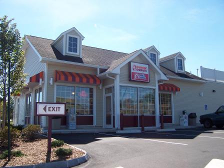 Tinkham GarageThe 375-acre Tinkham Garage Superfund site is located in Londonderry, New Hampshire. While in use as a garage during the late 1970s, operations discharged liquids and sludge at the site. In 1983, EPA placed the site on the Superfund program’s National Priorities List (NPL). Cleanup activities included groundwater and soil treatment, extension of the public water and sewer lines, and groundwater monitoring Groundwater monitoring and construction of additional water line extensions to nearby residents are ongoing. During site cleanup activities, EPA provided information to interested parties about appropriate reuse of the site. Today, stores and restaurants including a Home Depot, Staples, Dunkin’ Donuts and 99 Restaurant occupy the northeastern area of the site. The Woodland Village Condominium complex and several single family homes occupy the northern area of the site. The Nevins Retirement Cooperative Association completed construction of over 125 residences on the central area of the site. These residences are part of an active senior housing development. The site’s redevelopment has increased property values in Londonderry. Increased economic activity at the site has encouraged infrastructure improvements.
For more information:
Town Garage/Radio Beacon
The Town Garage/Radio Beacon Superfund site is located in Londonderry, New Hampshire. The site previously included a series of residential wells and one commercial well. The U.S. Department of Defense owned part of the site from the early 1940s until 1968 and operated a radio beacon there during World War II. A 1994 state inspection found contamination in many of the wells. Site investigations found that former site operations contaminated groundwater. In the late 1980s, owners of six residences affected by groundwater contamination in wells chose to connect to the local public water supply. As a precaution, several other residences have since connected to the public water supply. EPA placed the site on the Superfund program’s National Priorities List (NPL) in 1989. Cleanup activities have included annual monitoring of natural processes to clean up groundwater and placing restrictions to prevent the use of groundwater for household purposes. The success of EPA’s cleanup plan allowed for the reuse of the site. Today, the site includes two residential developments and a wetland area. The Holton Circle development includes about 25 homes and the Saddlebrook development includes 20 new homes. In 2014, EPA took the site off the NPL.
For more information:
Troy Mills Landfill
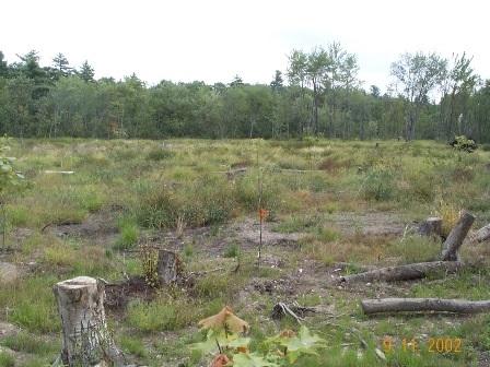
The Troy Mills Landfill Superfund site is part of a larger 270-acre parcel located in the rural town of Troy, New Hampshire. Troy Mills, Inc. used the property to dispose of solid waste and hazardous materials generated by its manufacturing plant. Troy Mills, Inc. filed for Chapter 11 bankruptcy in 2001. EPA placed the site on the Superfund program’s National Priorities List (NPL) in 2003. Cleanup actions included installing a system to collect free product from the groundwater. Cleanup also included removal of drums containing flammable liquid waste, waste sludge and contaminated soil. After removing contaminated soil, EPA backfilled excavated areas and covered areas with a soil cap. In 2005, EPA helped the local community identify appropriate reuses for the site. The community expressed interest in a passive recreation area that would include trails linking to the Cheshire County Rail Trail. Today, a trail network on site, completed in 2004, forms part of the 42-mile Cheshire Branch Rail Trail system. The trail provides space for a variety of recreation, including hiking, horseback riding, snowmobiling, mountain biking and cross-country skiing. Limited access to the site for recreational use will continue until EPA completes site cleanup activities.
For more information: