Superfund Sites in Reuse in Montana
If you are having trouble viewing the map in your browser, click the 'View larger map' link below
Anaconda Co. Smelter
 Anaconda Co. SmelterThe Anaconda Co. Smelter Superfund site is a former copper smelter located in southwest Montana. The site includes the towns of Anaconda and Opportunity. From 1884 to 1980, the smelter served as the cornerstone of the town economy. In 1980, the smelter closed and left more than 300 square miles of soil and water contaminated with heavy metals. In 1983, EPA added the site to the Superfund program’s National Priorities List (NPL). EPA collaborated with the community, ARCO (property owners of the former smelting facility), the State of Montana and Deer Lodge County to conduct a cleanup and redevelopment plan for the area. Developers turned 250 acres of the site into a 21-hole golf course. Designed by golf legend Jack Nicklaus, the course combines beautiful landscaping with historic mining artifacts. The design also includes an interpretive trail that winds around the golf course. A water drainage system recycles rainwater to water the golf course and surrounding property. Cleanup also addressed residential and commercial properties next to the golf course. Construction of numerous homes next to the golf course has taken place and plans for development of a mobile home park are underway. Cleanup activities to address arsenic contamination at residential properties began in 2003. ARCO has sampled more than 1,700 residential yards and cleaned up over 350 contaminated yards in Anaconda and the surrounding communities. Cleanup to address lead contamination in additional residential yards is ongoing. In 2008, Community, Counseling, and Correctional Services Inc. built a regional prison facility on a cleaned up area of the site. In 2009, removal of a contaminated, abandoned railroad west of Anaconda took place to make way for a highway, sewer and trail expansion project. NorthWestern Energy completed the construction of the Mill Creek Generating Station, a natural gas-fired electric generation facility, on the site in 2010. The facility opened in 2011 and anticipates that the station will generate about $200 million and employ 11 people during the station’s operation. The station will provide about $1.6 million per year in operating wage and employee benefits and generate about $8 million per year in property taxes. AWARE, Inc., a private, non-profit corporation that provides community-based services to persons with mental, emotional and physical needs also built a campus on site. Commercial development project are underway on cleaned up areas of the site. Additionally, the remedy has made 30 million cubic yards of slag material available for reuse. U.S. Mineral currently runs a commercial slag reuse operation, providing slag material for use as abrasives, roofing material, Portland cement and pig iron.
For more information:
Carpenter Snow Creek Mining District
The 9,000-acre Carpenter Snow Creek Mining District Superfund site includes about 90 abandoned mines in the Little Belt Mountains of Cascade County, Montana. From 1882 to 1929, operators of the Neihart Mining District mined zinc lead ore containing high concentrations of silver. The industry, infrastructure and population in the area grew quickly. Mining activities ceased after World War II but minimal exploration took place until 1980. Mineral extraction and processing left behind mine waste and mine influenced water on both public and private lands. In the early 1990s, the Montana Abandoned Mine Reclamation Bureau found metal concentrations at levels that are detrimental to human health and environment. EPA added the site to the Superfund program’s National Priorities List (NPL) in 2001. EPA selected a cleanup plan for residential soil in the Town Neihart in 2009. Monitoring and site characterization continues throughout the watershed while EPA works to select additional cleanup plans for the site. Cleanup efforts target surface soils and mine influenced waters. Major cleanup efforts so far include some contaminated soil removal in the Town of Neihart and mine tailing removal. Cleanup and monitoring activities continue. Residential, recreational and commercial use of on-site properties continue.
For more information:
East Helena Site
 East Helena SiteThe East Helena Superfund site is located in East Helena, Montana. The site includes a former lead smelter, the town of East Helena, several residential subdivisions and surrounding rural agricultural lands. Operated by Asarco, the smelter functioned from 1888 until 2001 and helped to define the community’s heritage. Smelter operations also led to the contamination of large portions of the former smelter facility, East Helena and the surrounding county. EPA added the site to the Superfund program’s National Priorities List (NPL) in 1984. Cleanup efforts began in the early 1990s when Asarco conducted soil removal in residential yards in East Helena. These efforts continued until 2011. Other cleanup activities included replacing leaking equipment, removing and storing contaminated soil and sediments, and treating contaminated water. Cleanup activities continue at the site. In the interest of future development, the City of East Helena annexed formerly Asarco-owned lands outside its city boundary in 2009. The community is now considering future land use, growth and development options. To support the community, EPA and the Montana Environmental Trust Group (trustee for the site after the 2009 Asarco bankruptcy) coordinated cleanup, local planning and development. The EPA Superfund Redevelopment Initiative funded a community planning charrette and reuse planning process. The reuse planning process involved 45 people from the local community in creating a development strategy for East Helena. The strategy focuses on land use and development, cultural heritage, and habitat and recreation. Current site uses are residential, agricultural, commercial and industrial.
For more information:
- East Helena, East Helena, MT - Reuse Plan (PDF) (12 pp, 6.6 MB, About PDF)
- Superfund Site Profile Page
Libby Asbestos Site
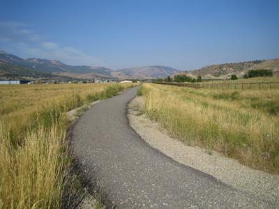
The Libby Asbestos Superfund site is located in the northwest corner of Montana and includes the City of Libby and the City of Troy. Gold miners discovered vermiculite in Libby in 1881, and mining began by the 1920s. Mining in Libby ended in 1990. W.R.Grace Company most recently owned and operated the mine operations. Vermiculite was used in everything from construction materials, such as insulation and tiles, to soil amendments and school craft projects. By some estimates, while in operation, the Libby mine might have produced more than 70 percent of the world's supply of vermiculite. Naturally occurring asbestos existed in the vermiculite mined on site and contaminated the area. In response to local concern and news articles about asbestos-contaminated vermiculite, EPA sent an Emergency Response Team to Libby in 1999. EPA’s Removal Program has conducted investigations and removal actions to address asbestos contamination at the site since 2000. In 2002, EPA added the site to the Superfund program’s National Priorities List (NPL). After extensive site and community investigations, EPA located contaminated properties and began residential cleanup. EPA has removed major sources of contamination around Libby and Troy. To date, EPA has worked with local, state and federal agencies to complete over 2,000 residential cleanups, as well as commercial cleanups. EPA completed the cleanup at a portion of the site, which is now in residential use. Also, EPA has worked with citizens, local officials, local stakeholder groups and businesses to support reuse of site. EPA coordinated cleanup actions to facilitate development of a steel bridge manufacturing facility, Stinger Welding. Stinger Welding operated at the site until 2013, when the facility closed. In the 1990s, the City of Libby acquired a 17-acre property at the site. In 2003, the community of Libby and EPA began working together to plan the future use of the property. In 2013, after years of planning, cleanup and restoration, the City of Libby opened Riverfront Park. This multi-use facility includes river access for boating, pavilions, a memorial, parking and picnic tables and fishing. Riverfront Park also hosts Libby’s annual Riverfront Blues Festival. EPA also worked with community members to complete cleanup of a golf course and to support development of a recreational trail and fishing pond. The site’s cleanup and reuse highlights successful cooperation between the private sector, the local government, and state and federal agencies.
For more information:
- Out of the Dust: Recreational Reuse After Vermiculite Mining at the Libby Asbestos Superfund Site in Libby, Montana (PDF) (18 pp, 2.8 MB, About PDF)
- Superfund Site Profile Page
Libby Ground Water Contamination
The Libby Groundwater Superfund Site is located on the eastern edge of Libby, Montana. The site’s groundwater contamination plume underlays part of the Kootenai Industrial Park. The site was part of a lumber and plywood mill, which treated wood on site between 1946 and 1969. In 1979, investigations discovered well water contamination at a nearby residence. EPA placed the site on the Superfund program’s National Priorities List (NPL) in 1983. Cleanup at the site began in 1986 and is ongoing. Cleanup activities included connecting residents to the municipal water supply, well closure and payments to owners, and treating soil and groundwater. Site stakeholders are considering installing a fishing pond on the former mill property. The site continues to support commercial and light industrial uses, as well as sawmill operations.
For more information:
Milltown Reservoir/Clark Fork River
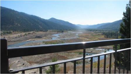 Milltown Reservoir/Clark Fork RiverFrom the 1860s until the late 20th century, the Clark Fork and Blackfoot Rivers region in western Montana was one of the richest mining regions in the world. Mining operations left large areas of waste and contamination. In 1983 and 1995, EPA listed the areas known as the Milltown Reservoir Sediments and the Clark Fork River portions of the site on the Superfund program’s National Priorities List (NPL). Together, these areas form the Milltown Reservoir/Clark Fork River Superfund site. Cleanup included removing sediments to restore drinking water and removing the historic Milltown Dam in 2010. Cleanup of the Clark Fork River portion is underway. Throughout the project, EPA worked with local communities, the State, and federal and tribal partners on a collaboration to link site cleanup, restoration and redevelopment. Assisted by an EPA Superfund Redevelopment Initiative pilot grant and EPA support, the communities developed a reuse plan in 2005. The plan called for the creation of a state park with trails, river access, wildlife habitat and interpretive areas celebrating the region’s history and heritage. In 2010, the State of Montana acquired portions of the site for the new Milltown State Park. The State allocated funding for the park’s development and land acquisitions. Several trails exist in the area and the State has plans to link the new park with the larger community trail network and the newly renovated pedestrian bridge. The overlook at Milltown State Park is now open, with main park areas anticipated to open in 2015. The renovated “Black Bridge” over the Blackfoot River is now home to the new Milltown Bridge Market, a local farmer’s market. In 2005, the Clark Fork Coalition also began managing a sustainable cattle ranch on the Clark Fork River portion of the site. In 2011 and 2012, parties restored the flood plain to a naturally functioning, self-sustaining river ecosystem. Site stakeholders will continue to monitor the drinking water supply, the fishery and the Clark Fork River floodplain.
- Integrating the "3 Rs": Remediation, Restoration and Redevelopment- The Milltown Reservoir Sediments Site and Missoula County, Montana (PDF)(14 pp, 2.3 MB, About PDF)
- Superfund Site Profile Page
Mouat Industries
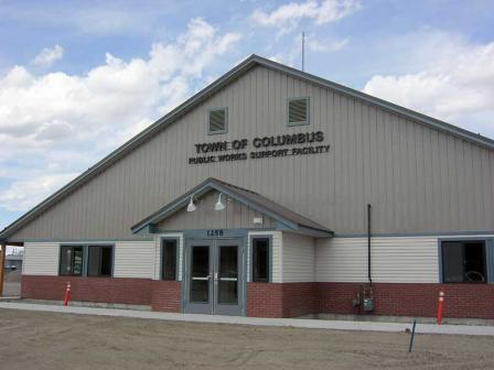 Mouat IndustriesThe 4.5-acre Mouat Industries Superfund site is located in Columbus, Montana. The site lies within the historic flood plain of the Yellowstone River. From 1957 to 1962, Mouat Industries operated a chromite ore operation and generated wastes that contaminated the soil and groundwater. After assessing the site and groundwater, EPA added the site to the Superfund program’s National Priorities List (NPL) in 1986. Working with EPA, the several potentially responsible parties (PRPs), including the Town of Columbus, treated contaminated soil, treated groundwater, and implemented groundwater and land use controls at the site. Cleanup construction reached completion in 1996. In August 2011, the Town of Columbus built its new public works building on part of the site. Timberweld, a wood manufacturing company, uses another part of the site for operational facilities and covered an area with gravel for use as a parking lot.
For more information:
Silver Bow Creek/Butte Area
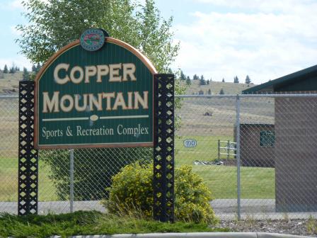 Silver Bow Creek/Butte AreaThe Silver Bow Creek Superfund site starts in Butte, Montana and runs west about 26 miles near Anaconda. The history of the site dates to the late 1800s, when miners dumped wastes into streams and wetlands near mining operations. This dumping severely polluted Silver Bow Creek and surrounding areas. As a result, EPA placed the site on the Superfund program’s National Priorities List (NPL) in 1983. Working together, EPA, Montana Department of Environmental Quality, the site’s potentially responsible parties (PRPs) and the community returned the site property to productive use. Redevelopment took place in manner compatible with the remedy to make sure the cleanup is effective and redevelopment consistent with local goals. The PRPs removed contamination, then capped and replanted the area for parks and new recreational fields. Cleanup included restoring wetlands that now serve as a key habitat for osprey and migrating Canadian geese. The Butte Natural Resource Damage (NRD) Restoration Council approved funds for the purchase and planting of trees in the new community park area on the site. Park trails now run through the site. The trails link a system of historic preservation sites in Butte and Walkerville called Montana’s Copperway. Park features include a sports complex with youth baseball fields, a driving range and golf course, walking trails with interpretive signs and stations, public restrooms and picnic areas. Restoration efforts are both historic, such as the Granite Mountain Memorial area that memorializes the 2,500 men who died in the Butte area mines, and creative, such as the Butte Hill Trail walking path that uses an abandoned railroad bed.
For more information:
- Building on Mining History: Cleanup, Reuse and Community Resilience at the Silver Bow Creek/Butte Area Superfund Site in Butte, Montana (PDF)(17 pp, 6.0 MB, About PDF)
- Superfund Site Profile Page
Upper Tenmile Creek Mining Area
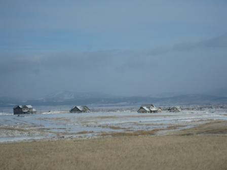
The Upper Tenmile Creek Mining Area Superfund site covers about 53 square miles in Lewis and Clark County, Montana. About 150 mines in the historic Rimini Mining District compose the site. Metals mining began in the 1870s and continued through the 1930s. Mine waste rock containing heavy metals contaminated soil, groundwater and surface water. The City of Helena obtains about 85 percent of its drinking water supply the Tenmile Creek watershed. In October 1999, EPA added the site to the Superfund program’s National Priorities List (NPL). EPA assisted state agencies in relocating mine waste from several abandoned mines to a central location designed to properly handle mine waste, known as the Luttrell Repository, from 1996 to 2001. EPA selected the cleanup plan for residential properties in the Rimini and Landmark subdivisions in 2002 and cleanup activities are ongoing. At the Rimini Road (Basin Creek Mine Road) area of the site, EPA completed cleanup in 2010. Cleanup is ongoing at the Priority Mine Waste area of the site, which includes the Lee Mountain/Little Lily Complex located in Rimini, as well as the Bunkerhill Priority Mine Waste Site Group. Relocation of additional waste to the Luttrell Repository and reclamation of excavated areas will also take place. EPA is working with the County and State to establish rules for groundwater use and to implement institutional controls to ensure future use of the site is compatible with the remedy. EPA is also working to complete the remedial designs for other areas of the site. The community of Rimini, a small residential subdivision at the mouth of the Tenmile Creek watershed, is located on site and includes residential homes and cabins. Additionally, large, undeveloped stretches of the site are also used for recreational activities.
For more information: