Superfund Sites in Reuse in Massachusetts
If you are having trouble viewing the map in your browser, click the 'View larger map' link below
Atlas Tack Corp.
The Atlas Tack Corporation Superfund site in Fairhaven, Massachusetts is about 48 acres and includes upland areas, wetlands and saltwater marsh. The former facility made a variety of metal products, including tacks and steel nails, from 1901 to 1985. Operations released waste containing acids, metals, and solvents into drains and an on-site, unlined lagoon located near a marsh area. Waste disposal practices resulted in contamination of soil, surface water, sediment and groundwater. In 1990, EPA placed the site on the Superfund program’s National Priorities List (NPL). In 2005, EPA began cleanup at the site. The cleanup activities included demolition of most of the remaining on-site structures, removal of contaminated soil, groundwater monitoring, and site restoration. EPA completed these activities in 2007, and began monitoring activities in 2008. The on-site wetland areas are expected to be fully restored to their pre-industrial conditions. Potential development at the site could include commercial and industrial reuse of the upland areas. EPA is working with the current owners of properties at the site to implement institutional controls that will ensure all future reuse of the site will be consistent with the selected site cleanup and protective of human health and the environment.
For more information:
Cannon Engineering Corp. (CEC)
 Cannon Engineering Corp. (CEC)The Town of Bridgewater worked with EPA to clean up and redevelop the 6-acre Cannon Engineering Corporation (CEC) Superfund site in Bridgewater, Massachusetts. Beginning in the 1970s, CEC transported, stored and burned hazardous wastes at the site. Mishandling of the waste and reporting violations led to the facility closing in 1980. In 1982, the state removed contaminated sludge and drums from the site. EPA added the site to the Superfund program’s National Priorities List (NPL) in 1983. In the mid-1990s, Osterman Propane Distribution (Osterman) relocated to the former CEC facility. Osterman stores and distributes propane at the site. It also sells gas appliances and related equipment. In 1998, Omnipoint Communications Enterprises, Inc. began leasing part of the site and constructed a cellular communication tower. In 2013, EPA with concurrence from the Massachusetts Department of Environmental Protection, took the site off the NPL. EPA continues to monitor the site by conducting a review of the cleanup actions every five years to make sure the cleanup remains protective of human health and the environment.
For more information:
Fort Devens-Sudbury Training Annex
The Fort Devens Sudbury Training Annex Superfund site, a former U.S. Army military installation, covers approximately four square miles and includes portions of the towns of Maynard, Stow, Hudson, and Sudbury, Massachusetts. Established in 1942, the site served as an ammunition depot, an ordnance test station, a troop training and research area, and a laboratory disposal area. EPA identified contamination resulting from use of pesticides and other chemicals on portions of the site and added the site to the National Priorities List (NPL) in 1990. The U.S. Army worked with EPA to remove contaminated soil, cover an on-site landfill with a cap, remove underground storage tanks, and monitor ground water. Currently, several entities own portions of the site. In 2000, the Army transferred 2,230 acres of the site to the US Fish and Wildlife Service (USFWS). USFWS established the Assabet River National Wildlife Refuge on the transferred land. In 2005, USFWS completed construction of walking trails within the refuge. In 2008, USFWS completed restoration of Russell Bridge. In 2010, a visitor center and other park amenities opened at the refuge. USFWS used green building techniques when constructing the visitor center, which includes a geothermal heating system and solar panels. The visitor center welcomes visitors Thursday through Sunday. The refuge provides recreational opportunities including hiking, canoeing, guided tours of the military bunkers on site, hunting and fishing. USFWS’s future plans for the refuge include educational demonstration areas, restoration of on-site bunkers, an urban education area and a rail-to- trail project at the abandoned railroad on the south side of the refuge. In 2002, the Army transferred four acres to the US Air Force (USAF). USAF uses the area for operation of a radar and weather station. In 2003, the Army transferred approximately 72 acres of the site to the Federal Emergency Management Agency (FEMA). FEMA uses the land for its operations and training missions. FEMA has cleared six acres for use as a temporary antenna field.
For more information:
GE - Housatonic River
The GE-Pittsfield/Housatonic River (GE-Housatonic River) site includes a 254-acre former manufacturing facility, filled river oxbows, neighboring commercial properties, Allendale School, Silver Lake and other areas. The site contains contamination released from the General Electric Company (GE) facility in Pittsfield, Massachusetts. The site also includes the Housatonic River and floodplains from Pittsfield, Massachusetts to Long Island Sound. The portion of the river beginning two miles south of the GE facility is referred to as Rest of River. A cleanup decision on Rest of River is currently pending. A consent decree entered in federal court in 2000 specified the cleanup of all other areas of the site. Since 2000, extensive cleanup of the site has occurred. Eighteen of 20 cleanup actions outside the river are complete. Cleanup of the Unkamet Brook Area (the 19th cleanup action) is currently underway. The remaining cleanup action outside the river is expected to be completed within the next three years. Two miles of the Housatonic River have also been cleaned up. As part of ongoing cleanup activities, the community prioritized the reuse of the former GE facility, located in the heart of downtown Pittsfield. Funded by a Superfund Redevelopment pilot grant, the Pittsfield Economic Development Authority (PEDA) developed a reuse plan. The reuse plan outlined opportunities for sports fields and an office park. In 2004, GE built a 3-acre recreational facility on site for the community. The facility includes a baseball diamond, soccer field, jogging track, equipment storage, fencing and lighting. Between 2005 and 2012, PEDA received ownership of 50 acres of the site for the development of the William Stanley Business Park. The William Stanley Business Park provides commercial and industrial space for area businesses. The Park’s first tenant, a financial services company, built a 170,000 square-foot building, which officially opened in June 2012. Western Massachusetts Electric Company installed an 8-acre solar power facility in 2010, using 2 acres of the site and 6 acres from an adjacent property. In 2014, PEDA received a $9 million grant from the State to design and build the Berkshire Innovation Center. The facility support shared research, early-stage production and commercialization, and work force training for life science companies and related businesses. There is also reuse of the GE-owned portion of the 254-acre facility, where two large employers continue to operate. Several land uses have continued on the non-GE owned portion of the site (excluding the Rest of River), including an elementary school, about 86 residential properties, about 35 commercial properties and a city park.
For more information:
Groveland Wells
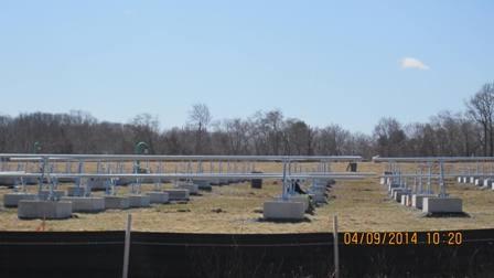
The 850-acre Groveland Wells Superfund site is located in Groveland, Essex County, Massachusetts. Groveland Resources Corporation (GRC) and Valley Manufactured Products Company, Inc. (Valley) produced metals and plastic parts on the property until 2001. GRC and Valley released cutting oils and chlorinated solvents on the site. Additional waste leaked from storage tanks and disposal systems at the Valley facility. Site releases contaminated the Town of Groveland’s public water supply. EPA placed the site on the Superfund program’s National Priorities List (NPL) in 1982. In late 1987 and early 1988, EPA used soil vapor extraction to remove contaminants from site soils. GRC and Valley installed a groundwater extraction and treatment system in 1988. EPA installed an additional extraction and treatment system in 2000. In 2006, EPA eliminated the source wastes by removing storage tanks and leakage field soils from the site. A sand and gravel operation and the Groveland Department of Public Works continue to operate on site. A 3.5 megawatt solar panel installation on the site powers more than 500 homes. Residential, commercial and industrial land uses continue at the site.
For more information:
Hatheway & Patterson
 Hatheway & PattersonThe 38-acre Hatheway & Patterson Superfund site is located in Mansfield and Foxborough, Massachusetts. The site includes the area where the Hatheway and Patterson Company operated a wood preserving facility from 1953 until 1993. Releases of chemicals used during these operations resulted in soil and groundwater contamination, as well as contamination of sediment and surface water in the Rumford River’s fisheries and surrounding wetlands. EPA placed the site on the Superfund program’s National Priorities List (NPL) in 2002. The site received about $20 million through the American Recovery and Reinvestment Act of 2009 for cleanup activities. The funding helped to jump-start the final phase of the cleanup and allowed for parts of the site to be put into reuse right away. Today, part of the site located in Foxborough, includes a 119-space commuter parking lot. Commuters parking in the lot can take the Greater Attleboro Taunton Regional Transit Authority’s free shuttle service to and from the nearby Mansfield commuter rail train station. The Town of Mansfield uses part of the site north of the railroad tracks for emergency vehicle storage and the one remaining building for office space.
For more information:
Industri-Plex
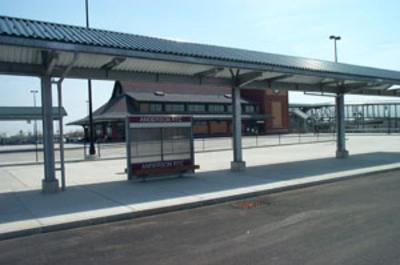 Industri-PlexThe Industri-Plex Superfund site in Woburn, Massachusetts is located 12 miles outside of Boston. From 1853 to 1969, several manufacturers produced chemicals, insecticides, munitions and glue products at the site. Large waste piles, heavy metals and hazardous chemicals collected on site. This waste resulted in groundwater, surface water, soil and sediment contamination. In 1983, EPA placed the site on the Superfund program’s National Priorities List (NPL). EPA and the State of Massachusetts built protective covers over contaminated parts of the site. The covers allowed for productive reuse of the areas. During and after initial cleanup activities, several public and private sector improvements took place at the site. These improvements included a new interstate highway exchange, public roads, a 200,000 square-foot shopping center, an office park and a hotel complex. Restored wetlands and grass-covered hills provide scenic open space at the site. EPA recognized the site’s successful redevelopment with the prestigious Phoenix Award in 2000. In 2001, the 34-acre, $10-million James Anderson Regional Transportation Center opened at the site. The center relieves congestion on highways leading into Boston and eases commutes for many area residents. EPA continues to support redevelopment opportunities at the Industri-Plex Superfund site. In 2008 and 2009, redevelopment included a Chipotle Restaurant, a PetSmart, and a 27,000 square-foot Bob’s Discount Furniture Store. EPA and the state approved the transfer of the existing developed property to a developer. EPA, the state and local government worked with the developer to record property use restrictions, prepare work plans, tear down the existing building and transform the property.
For more information:
- Reuse and the Benefit to Community: Industri-Plex Case Study (2014) (PDF) (21 pp, 1.6 MB, About PDF)
- Superfund Site Profile Page
Iron Horse Park
 Iron Horse ParkThe Iron Horse Park Superfund site is a 553-acre industrial complex in Billerica, Massachusetts. Industrial activities, which began in 1913, included manufacturing, rail yard maintenance, waste storage and landfilling. Operations resulted in soil, groundwater and surface water contamination at the site. EPA added the site to the Superfund program’s National Priorities List (NPL) in 1984. Site cleanup activities are ongoing. Cleanup activities included removal of contaminated soil, filling areas with clean soil, and closing and capping landfills. EPA’s cleanup activities supported the continued operation of various industrial businesses on site. These include lumber, manufacturing and rail yard maintenance facilities. Cleanup activities also restored natural marshes and new wetland habitats. In 2012, site stakeholders began a project to place solar panels on a former on-site waste disposal area called Shaffer Landfill. After coordinating with EPA and the state, the Town of Billerica signed a payment in lieu of taxes (PILOT) agreement in August 2013. The PILOT agreement guarantees project revenue over 25 years. With the agreement in place, construction of the 25-acre solar array began in early 2014. Urban Green Technologies (UGT), the solar developer, placed 20,000 solar panels over the capped landfill. EPA worked with UGT to address the engineering challenges of installing solar panels on the sloped landfill while ensuring the landfill cap remained intact. In August 2014, EPA, the Massachusetts Department of Environmental Protection, UGT and the Town of Billerica held a ceremony marking the project’s completion. The six megawatt facility at the site allows Billerica to reduce dependence on fossil fuels and gain significant long-term energy cost savings. In 2014, EPA recognized the project team, including the Town of Billerica, UGT and Capital Dynamics, with Region 1’s first Excellence in Site Reuse award.
For more information:
- Redevelopment of the Shaffer Landfill portion of the Iron Horse Park Superfund Site (PDF) (1 pg, 364 K, About PDF)
- Superfund Site Profile Page
Materials Technology Laboratory (USARMY)
The Materials Technology Laboratory (USARMY) Superfund site, better known as the “Arsenal”, is located in Watertown, Massachusetts. In 1816, the U.S. Army began their operations at the site and employed 10,000 people by the end of World War II. The Army used the site for a variety of military- and war-related activities, including weapons and ammunition manufacturing and storage, as well as nuclear reactor and molecular and atomic structure research activities in the 1960s. In 1987, the Army discovered contamination during a site inspection. EPA added the site to the National Priorities List in 1994. Cleanup activities removed contamination and demolished an on-site nuclear reactor. From 1996 to 2005, the Watertown Arsenal Development Corporation (WADC), helped to facilitate redevelopment of 30 acres of the site. Harvard University purchased the area and constructed a mixed use complex called Arsenal on the Charles, which incorporates the style and architecture of the original brick buildings in the area. The complex includes apartments, retail stores, restaurants, a child care facility, a fitness center, corporate offices and various other businesses. The Arsenal Center for the Arts, also located within the complex, serves as an important cultural asset to the community with a theater, gallery space, artists’ studios, and other resources and services. The Commander’s Mansion, a historic landmark, occupies a 7.2 acre area of the site and provides a space for meetings and formal functions. The popular Squibnocket Park is located on an 11-acre parcel along the Charles River and provides biking and walking trails, as well as access to the Watertown Yacht Club, a privately-owned marina that has been operating since 1940. The Army restored wetlands along the Charles River and EPA deleted the site from the NPL in 2006.
For more information:
New Bedford
The New Bedford Harbor Superfund site includes 18,000 acres in New Bedford, Massachusetts. At least two companies produced electric devices on site from 1940 to the late 1970s. Operations discharged industrial wastes into the harbor, which contaminated the estuary from the upper Acushnet River into Buzzards Bay. In 1983, EPA placed the site on the Superfund program’s National Priorities List (NPL). Ongoing cleanup activities include removing and capping contaminated sediments. Cleanup plans also include removal of contaminated sediment and wetland restoration at shoreline properties. Dredging has taken place at the site for over 10 years. The site received $30 million through the American Recovery and Reinvestment Act of 2009 to support cleanup activities. EPA expects the cleanup will be substantially completed within five to seven years. After site cleanup, New Bedford will reuse EPA’s shoreline dewatering facility as an intermodal transportation facility. The facility, located on the City’s working waterfront, will include 350 feet of berthing space for freighters or commercial fishing vessels, a 55,000 square-foot warehouse, and a rail spur connecting to the City’s rail yard. In 2009, cleanup activities led to the discovery of a shipwrecked vessel in the harbor. Archeological testing dated the vessel between the late 1700s and early 1800s. In 2011, EPA completed demolition of the 11-acre Aerovox mill, located along the Acushnet River. The area will provide the City with space for future redevelopment. Local residents use the harbor for recreational activities such as rowing. Additionally, the site cleanup plan includes a component to allow additional dredging efforts by local and state stakeholders. Dredging of the harbor, which enhances the remedy at the site by removing sediment not addressed under the Superfund cleanup, has resulted in improvements to the harbor as a commercial port, as well as the recent construction of the New Bedford Marine Commerce Terminal, a 28-acre marine terminal. Redevelopment continues to take place along the river, including repurposing of abandoned mills for residential apartments and new commercial redevelopment. Reuse plans along the river include a Riverwalk along both sides of the Upper Harbor and significant habitat restoration, which aim to reconnect the community to the river. EPA’s cleanup will address site contamination along the shoreline prior to construction of the Riverwalk. Completion of the cleanup will allow for further redevelopment and repurposing of buildings along the shoreline.
For more information:
Norwood PCBs
 Norwood PCBsThe 26-acre Norwood PCBs Superfund site is located in a commercial area of Norwood, Massachusetts. Beginning in 1942 until the mid-1980s, several businesses manufactured and maintained electrical components at the site. During site investigations, EPA found polychlorinated biphenyls (PCBs) in the soil and groundwater on site and in sediment of a nearby brook. In 1986, EPA placed the site on the Superfund program’s National Priorities List (NPL). Cleanup at the site included removing and consolidating contaminated soil and sediment beneath an asphalt cap. Cleanup also included demolishing on-site structures and long-term monitoring. A groundwater treatment facility operated on site until 2001. In 2008, the site property owner and developers completed a 56,000 square-foot commercial/retail space. Developers located the new buildings next to the “permanent cap area.” They increased the thickness of the asphalt cap remedy to allow for its use as a parking lot. EPA took the site off the NPL in 2011.
For more information:
Nyanza Chemical Waste Dump
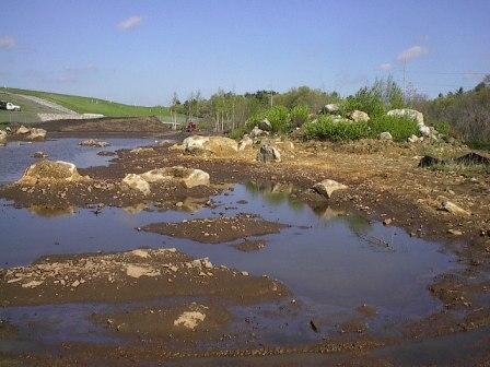
 Nyanza Chemical Waste DumpThe 35-acre Nyanza Chemical Waste Dump Superfund site is located in Ashland, Massachusetts. From 1917 to 1978, companies made textile dyes, dye intermediates and other products at the site. Operators buried solid waste on site and released wastewater to a system of creeks and outfalls that discharged to nearby surface water bodies, including Eastern Wetland and the Sudbury River. Improper waste handling practices resulted in groundwater, soil, sediment and surface water contamination. Indoor air sampling from residences located downgradient from the site and above the groundwater plume showed potentially unsafe levels of vapors. EPA placed the site on the Superfund program’s National Priorities List (NPL) in 1983. Cleanup included removing sludge and contaminated soils and sediments, placing a cap over contaminated soils, and installing systems to mitigate vapors from coming into homes. Cleanup also included extensive wetland restoration. Cleanup activities are ongoing for some portions of the site. In 2013, EPA completed the cleanup design to address contamination in the Sudbury River. Based on sampling conducted in 2014, EPA plans to place a thin sand cap over an 86-acre portion of the river. Several businesses, including Nyacol Nano Technologies, Inc., continue to operate at the site.
For more information:
Otis Air National Guard Base/Camp Edwards
The 22,000-acre Otis Air National Guard Base/Camp Edwards Superfund site is located on western Cape Cod in Barnstable County, Massachusetts. Also known as the Joint Base Cape Cod (JBCC) (formerly known as Massachusetts Military Reservation (MMR) until July 13, 2013), the site lies about 60 miles south of Boston and immediately southeast of the Cape Cod Canal. Since its establishment in 1935, the MMR’s primary mission has been to provide training and housing to U.S. Air Force and U.S. Army units. Historical chemical and fuel spills; fire training activities; and sewage treatment plant, landfill and drainage structure operations contaminated site soil and ground water. Investigations in 1983 and 1984 found volatile organic compounds (VOCs) in on-site and nearby monitoring wells as well as in several hundred private wells. The main contaminants of concern include VOCs and heavy metals. EPA listed the site on the National Priorities List (NPL) in November 1989 and documented the site cleanup plan in over 15 Record of Decision (ROD) documents. Cleanup activities include the installation of water supply lines to affected residents, installation of municipal water supply well treatment systems, treatment of 100,000 tons of soil, and construction and operation of many on-site and off-site ground water treatment plants. The treatment plants include extraction and reinjection wells and treat about 10.6 million gallons of contaminated ground water per day. EPA has completed cleanups at 25 separate source areas and issued a preliminary close-out report in December 2009. This report marked the completion of all remedy construction activities at the site. The Barnstable County Correctional Facility, a jail with a capacity for about 580 inmates, began operating on site in 2004. The Air Force installed a total of three 1.5 megawatt wind turbines – one in 2009 and two more in 2011 – to offset electrical costs for powering numerous ground water cleanup systems at the MMR. The Air Force estimates that the wind energy saves about $1.5 million a year in electrical costs. EPA’s cleanup plans allowed continued site operations throughout the cleanup process. Today, five major organizations continue to use the MMR: 1) The Massachusetts Air National Guard (ANG) operates Camp Edwards 2) The ANG/Massachusetts ANG operates Otis ANG Base 3) The U.S. Air Force operates Cape Cod Air Force Station 4) The U.S. Coast Guard operates Air Station Cape Cod 5) The U.S. Department of Veterans Affairs operates the Massachusetts National Cemetery.
For more information:
Re-Solve, Inc.
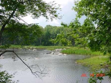
The 6-acre Re-Solve, Inc., Superfund site is a former waste chemical reclamation facility in North Dartmouth, Massachusetts. Between 1956 and 1980, site operators disposed of residues from operations, liquid sludge waste, impure solvents and burned tires in on-site unlined lagoons. Site operators also spread oil waste over the site to control dust. In 1980, the state and Re-Solve agreed that Re-Solve would surrender its license to accept waste on the condition that Re-Solve removed all hazardous waste from the site. In 1981, legal action resulted in the removal of all drums, debris and buildings at the site, but the contents of the lagoons remained. EPA placed the site on the Superfund program’s National Priorities List (NPL) in 1983. EPA and the site’s potentially responsible parties (PRPs) constructed a groundwater pump, containment and treatment system at the site. The system has operated continuously since 1998. As part of the cleanup activities, EPA and the PRPs cleaned up and restored 1 acre of wetlands at the site. The PRPs also worked closely with EPA and the U.S. Fish & Wildlife Service (USFWS) to convert 4 acres of the site into a native meadow for ecological reuse. The PRPs placed bird boxes, brush piles and sand piles for turtles to enhance the meadow habitat. A fishing derby takes place annually at Cornell Pond on site to engage the local community in fish monitoring activities. Additionally, EPA and the PRPs evaluated potential sustainable enhancements to the groundwater treatment system that would achieve remedy standards and reduce energy, product consumption & off-site disposal costs. In 2011, EPA approved a full-scale pilot project that includes Anaerobic Bioreactor (ABR) Beds and a solar facility. The groundwater treatment system has been operating with the enhancements for over 2 years and demonstrates compliance with remedy standards while reducing operational costs.
For more information:
- Redevelopment of the Re-Solve, Inc. Superfund Site (PDF)(1 pg, 1.6 MB, About PDF)
- Superfund Site Profile Page
South Weymouth Naval Air Station
The South Weymouth Naval Air Station consists of 1,442 acres in the towns of Weymouth, Abington and Rockland, Massachusetts. Historically, military operations at the site included aviation training, aircraft maintenance and refueling, personnel training, housing and administrative support services. Waste disposal activities also took place at the site and included three landfills, a tile leachfield used for the disposal of battery acid and burn pits for fire training. After sampling confirmed on-site contamination in 1991, EPA added the site to the National Priorities List (NPL) in 1994. The base closed under the Base Realignment and Closure Act (BRAC) and cleanup began in 1997. The local reuse authority, the U.S. Coast Guard and the Federal Aviation Administration have received over 600 acres of the site. Redevelopment negotiations between the Navy and private developers took place from 1997 until 2011, when a private developer purchased the remaining site acreage. The $25 million transaction provides the developer, LNR Property Corp., with land to complete redevelopment work on a new mixed use community at the site called SouthField. Following its completion, SouthField will include 2,800 homes, 2 million square feet of stores and offices, a golf course, athletic fields and other facilities.
For more information:
Sullivan's Ledge
 Sullivan's LedgeThe Sullivan’s Ledge Superfund site is located in New Bedford, Massachusetts. The site includes a 12-acre former quarry that operated until 1921. In 1935, the City of New Bedford assumed ownership of the site and converted it into a dump for hazardous materials. Waste disposal activities took place at the site from the 1940s until the 1970s, when the City closed the dump and backfilled the disposal areas. In 1982, during investigations associated with the proposed development of the area as a commuter parking lot, the Massachusetts Department of Public Works, now the Massachusetts Highway Department, found soil contamination at the site. As a result, EPA conducted studies in the area and subsequently placed the site on the Superfund program’s National Priorities List (NPL) in 1984. Cleanup activities included placing a cap over the site, removing contaminated soil and sediment, and removing contamination from a neighboring golf course. EPA conducted cleanup activities in a way that allowed for continued use of the golf course during the cleanup process. EPA also restored 13 acres of affected wetlands. Restoration work reached completion in 2000. Today, the wetlands provide habitat for many wildlife species, including the great blue heron, great egret, red-tail hawk and spotted turtle. In 2013, EPA approved the installation of a 1.75-megawatt solar project on the capped area of the site. Project partners SunEdison, Inc., Beaumont Solar, Pro-Tech Energy Solutions and BlueWave Capital LLC announced completion of the system’s construction in September 2014. The 10-acre system includes more than 5,000 solar panels. A partnership between BlueWave Capital and the City of New Bedford is helping further solar projects around New Bedford. The City of New Bedford buys energy generated from the solar arrays, which enables the City to increase its use of renewable energy sources and save 30 percent on municipal electricity bills. Over the course of 20 years, New Bedford will accumulate about $2.7 million in energy savings through the purchase of solar net metering credits. In 2014, EPA recognized the project team, including the City of New Bedford, BlueWave Capital and SunEdison, with Region 1’s first Excellence in Site Reuse award. EPA will continue to ensure the cap’s integrity as reuse continues.
For more information:
- Utility-Scale Solar Energy Development: The Sullivan's Ledge Superfund Site in New Bedford, Massachusetts (PDF)(14 pp, 3.5 MB, About PDF)
- Superfund Site Profile Page
Wells G&H
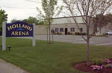 Wells G&HThe Wells G & H Superfund site includes 330 acres of land and contaminated groundwater in Woburn, Massachusetts. Historical operations at the site included dry cleaning, solvent storage, truck terminals, drum disposal and plastics manufacturing. In 1979, the Massachusetts Department of Environmental Protection (MassDEP) discovered significant levels of hazardous chemicals in two municipal supply wells, known as Wells G and H. MassDEP closed the wells. EPA placed the site on the Superfund program’s National Priorities List (NPL) in 1983. Cleanup activities include removing debris and contaminated soils, treating and burning contaminated soils on site, removing and treating groundwater, and restricting land and groundwater use. In 2002, the City of Woburn’s Redevelopment Authority began exploring reuse options for the site. Recommendations for three parcels within the site included an ice skating rink, office and retail space, and nature and walking trails. At the first parcel, the property owner seized the opportunity to construct an ice skating rink. The property owner cleared a junkyard of dismantled cars and transformed a portion of the parcel into an ice skating arena. Completed in 2008, the successful new ice arena provides recreational opportunities for a community that places a high value on the sport of ice hockey. The property owner also leases other portions of the property to small businesses for local community needs including a dog care facility, bus storage yard and an auto supplier shop. EPA also supports the commercial reuse of the second parcel, which has been recently proposed for hotel and restaurant development. The City of Woburn owns the third parcel and plans to reuse the parcel for ecological and recreational purposes, complete with wildlife viewing platforms and hiking trails upon completion of adjacent sediment cleanup activities.
For more information: