Superfund Sites in Reuse in Washington
If you are having trouble viewing the map in your browser, click the 'View larger map' link below
Alcoa (Vancouver Smelter)
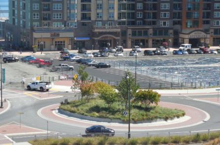
The 300-acre Alcoa (Vancouver Smelter) Superfund site is located next to the Columbia River in Vancouver, Washington. The former Aluminum Company of America (Alcoa) constructed an aluminum smelter on a portion of the site in 1940. Alcoa operated the facility until 1985. From 1973 until 1981, operators dumped tons of potliner containing cyanide and fluoride outside the smelter on the ground. Potliner is a special lining material that protects steel pots that are used to process molten aluminum. The dumping contaminated the soil and groundwater. In 1990, EPA added the site to the Superfund program's National Priorities List (NPL). The state worked with Alcoa to remove and dispose of hazardous soil, making the valuable riverfront property available for use. EPA deleted the site from the NPL in 1996. In 2002, Evergreen Aluminum (Glencore) purchased the facility, although Alcoa retained ownership of some of the land. In 2009, the Port of Vancouver completed the purchase of about 218 acres formerly owned by Evergreen Aluminum and Alcoa Aluminum. The land purchase allowed the Port to develop its newest marine terminal, Terminal 5. Less than a month after closing on the property, the Port had graded and surfaced a 30-acre area and began handling wind energy cargo on the new terminal. In 2010, BHP Billiton, the world’s largest mining company, selected Terminal 5 as its preferred site for a new potash export facility. The proposed facility plans to handle eight million tons of potash annually at its peak as well as create between 1,500 to 2,000 construction jobs and 40 permanent employee positions.
For more information:
American Crossarm & Conduit Co.
The redevelopment of the American Crossarm & Conduit Co. Superfund site in Chehalis, Washington, marked the end of a legacy of contamination and the beginning of a new chapter for the property. During its operation, American Crossarm & Conduit Co. dumped wastewater contaminated with wood treating chemicals, fuels, and solvents into an unlined pit on the 16-acre site. This activity combined with periodic flooding from nearby rivers, spread hazardous wastes to nearby properties and contaminated the ground water. In 1989, EPA listed the site on the Superfund program's National Priorities List (NPL). Cleanup actions included removing contaminated soil, demolishing contaminated site structures, removing oil from groundwater and covering excavated areas with clean soil. Despite the site’s favorable location, a $15.5 million EPA cleanup lien against the site presented a barrier to developers. In the late 1990s, EPA agreed to remove its lien on the condition that any new owners add fill so the property would be above the flood plain. Owners must also agree not to dig into the site’s cap, use the groundwater or sell the property without passing on the land use restrictions. This agreement made redevelopment a reality at the site with a new on-site structure constructed in 1998. After construction, the owner sold the building, which is currently being used as a machine and repair shop. A second two-story building constructed on site currently houses a fitness center.
For more information:
Asarco Inc.
 Asarco Inc.The Asarco Inc. Superfund site is located in Ruston and Tacoma, Washington on Commencement Bay. It is part of the Commencement Bay/Nearshore Tideflats Superfund site. Like many other ports across the country, the shores of Commencement Bay have long been home to industry. The cleanup and redevelopment of the 67-acre Asarco Tacoma Smelter site is a model of cooperation among EPA, the local community and a land development company. From 1890 to 1985, Asarco used the site to smelt and refine lead and copper. Site activities resulted in the release of metals into the soil, air, bay and groundwater. In 1983, EPA listed the site to the Superfund program's National Priorities List (NPL). After public meetings, Asarco and EPA developed a comprehensive plan for cleanup that included local reuse ideas. In 2005, after filing for bankruptcy, Asarco entered into an agreement with MC Construction Consultants to sell the site and another nearby Asarco property. MC Construction Consultants then assigned its purchase rights to Point Ruston, LLC in order to develop a large-scale residential and mixed-use community called Point Ruston. After finalizing agreements with EPA in 2006, Point Ruston, LLC purchased the property and agreed to take over the cleanup of the site and some other outlying areas. EPA required Point Ruston, LLC to clean up the Asarco smelter, cap slag, cleanup offshore sediments and remove shallow sediments from a nearby basin. As part of the cleanup approach, EPA allowed Point Ruston, LLC to combine the development of the site with site capping. The buildings and hard surfaces of the development would become the cap. Point Ruston, LLC started construction of the foundations of two condominiums on the site in 2008. Once complete, Point Ruston will also include retail shopping, a hotel, community activity plaza and shoreline recreational opportunities.
For more information:
Bonneville Power Administration Ross Complex (USDOE)
The 250-acre Bonneville Power Administration Ross Complex (USDOE) Superfund site is located north of Vancouver, Washington. The site is an active facility. The Bonneville Power Administration (BPA) has owned and operated the facility since 1939. BPA coordinates the distribution of hydroelectric power generated by the Federal Columbia Power System to regions throughout the Pacific Northwest. Since its construction, the site has provided research and testing facilities, maintenance and construction operations, and waste storage and handling operations for BPA. Improper storage and handling of materials on site resulted in the contamination of soil and ground water. EPA listed the site on the National Priorities List (NPL) in 1989. PBA undertook early cleanup actions beginning in 1991 and completed long-term cleanup actions by 1995. Cleanup actions included excavation and off-site disposal of contaminated soil, bioremediation and capping of contaminated soils, and ground water monitoring. EPA deleted the site from the NPL in 1996. BPA later enacted institutional controls to restrict digging in areas of the site with residual contamination in soils and limit future uses of these areas.
For more information:
Boomsnub/Airco
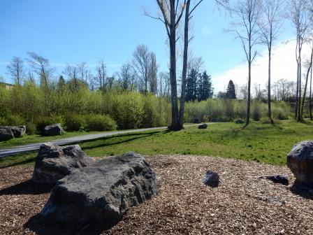
The Boomsnub/Airco Superfund site is located in a light industrial and residential area of Vancouver, Washington. The site includes two facilities, the former Boomsnub Corporation (Boomsnub) chrome plating facility and the Linde facility. Linde owns and operates an industrial gas production facility next to the Boomsnub property, which closed in 1994. Washington Department of Ecology (Ecology) found chromium in Boomsnub soils and groundwater in 1986. In 1991, Ecology found volatile organic compounds (VOCs) at the Linde facility during cleanup of chromium at the Boomsnub facility. In 1995, EPA listed the site on the Superfund program's National Priorities List (NPL) because of contaminated groundwater and soil. The area of contaminated groundwater extends from the two properties about 0.5 miles, underlying industrial, commercial and municipal facilities. Efforts to clean up groundwater and soil began in the early 1990s and included the removal of tons of contaminated soil. In 1990, EPA installed a groundwater treatment system that continues to treat and monitor groundwater. In 2011 and 2012, the City of Vancouver established the 20-acre Luke Jensen Sports Park over a portion of the site. The park includes Little League sports fields, batting cages and a walking trail. Commercial businesses, residential development and other industrial operations are also located within the site.
For more information:
- Redevelopment of the Boomsnub/Airco Superfund Site (PDF)(1 pg, 200 K, About PDF)
- Superfund Site Profile Page
Commencement Bay, Near Shore/Tide Flats
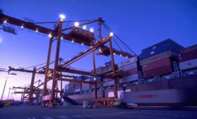
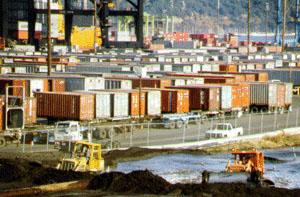 Commencement Bay, Near Shore/Tide FlatsThe Commencement Bay, Nearshore/Tide Flats Superfund site is located in the City of Tacoma and the Town of Ruston, Washington. The site encompasses an active commercial seaport at the southern end of Puget Sound, with 10 to 12 square miles of shallow water, shoreline and adjacent land. The site also includes the former Asarco Tacoma Smelter, contaminated sediments offshore of the smelter, and areas of Tacoma and Ruston contaminated by smelter emissions. Most of the area is highly developed and industrialized. Located within a tribal Usual and Accustomed fishing area, the tidal areas of the site support important recreational and tribal fisheries. Beginning in the late 1800s, shipbuilding, oil refining, chemical manufacturing and storage, and other industrial activities occurred at the site. These activities resulted in contamination of soil, groundwater, and sediment within and/or adjacent to waterways within Commencement Bay. In 1983, EPA added the site to the Superfund program's National Priorities List (NPL). EPA began working with the state and the Port of Tacoma to design and begin cleanup for the Sitcum Waterway portion of the bay. By using a waterway as a confined disposal site for contaminated sediments, cleanup activities resulted in newly available land on the Milwaukee Waterway. The additional space allowed an existing land-sea marine terminal facility to expand and increase the volume of its business. This expansion helped make the Port of Tacoma the seventh largest container port in the nation. As part of the St. Paul Waterway cleanup, potentially responsible parties restored 11 acres of shallow marine habitat for ecological reuse. Cleanup activities also allowed for the construction of the colorful Chihuly Bridge of Glass public art project and the restoration of 70 acres of estuarine habitat. In 2009, the site received about $5.2 million in American Reinvestment and Recovery Act (ARRA) funds. These funds supported activities at the Ruston/North Tacoma study area, the area contaminated by the Asarco Tacoma Smelter. These resources helped complete residential, parkland and right-of-way cleanups. In 2006, a development company purchased the property formerly occupied by the Asarco Tacoma Smelter, which consisted of 67 acres along Ruston Way on Commencement Bay. The company began construction on a project called Point Ruston. Redevelopment at Point Ruston is underway with the ultimate goal of completing over 200 residences, including single-family homes, apartments and condominiums. In July 2014, the second phase of the Point Ruston development began with a growing demand for retail space including a sushi restaurant, seafood house and a theatre. Most Point Ruston residences will incorporate green building principles. EPA continues to work with landowners and local governments to coordinate cleanup plans that include local goals and priorities for future land use.
For more information:
Commencement Bay, South Tacoma Channel
The Commencement Bay, South Tacoma Channel Superfund site is located in Tacoma, Washington and consists of three separate areas: the South Tacoma Field, the Tacoma Landfill and Well 12A. EPA added the site to the Superfund program's National Priorities List (NPL) in 1983. South Tacoma Field is a 260-acre area historically used by Burlington Northern Railroad for rail car manufacturing, repair and maintenance activities from 1892 to 1974. Two foundries also operated at this site in support of the railroad. Tacoma City Light has continuously operated on the north end of South Tacoma Field since 1953. All of these activities caused soil contamination throughout the site, as well as localized groundwater contamination. Cleanup activities included soil removal and soil capping, land use restrictions and monitoring of natural processes to clean up groundwater. Residents use the western side of the South Tacoma Field for casual recreation such as biking, dog walking and flying model airplanes. Businesses operating on the southern half of the South Tacoma Field include Pioneer Builders Supply, General Plastics and Industrial Properties, which leases warehouse, office and yard space to businesses. The City of Tacoma operates the Tacoma Landfill, which covers approximately 210 acres. Since 1960, operators accepted municipal, industrial, construction, demolition and bulk wastes on site. Operations contaminated soil and groundwater with volatile organic compounds (VOCs) and heavy metals. Landfill gas also contains VOCs. Cleanup activities included construction of a landfill cap, management of landfill gas and treatment of groundwater. After discovery of contamination in Well 12A (a City of Tacoma drinking water well) in 1981, EPA began pumping and treating the water in 1983. Cleanup activities also included removing contaminated soil and sludge, using heat and microbes to treat contaminated soil and groundwater, and installing a system to extract vapor from soil. Further cleanup activities to treat remaining soil contamination are currently underway. Western Moving and Storage and Sine Communications currently use the Well 12A area for storage and office space.
For more information:
FMC Corp. (Yakima Pit)
 FMC Corp. (Yakima Pit)The 4-acre FMC Corp. (Yakima Pit) Superfund site is located in Yakima, Washington. The site operated as a pesticide formulation facility from 1951 until 1986. From 1952 to 1969, FMC disposed of agricultural pesticides in a pit on site. A 6-foot chain link fence limits access to the pit area. EPA listed the site on the Superfund program's National Priorities List (NPL) in 1983 after finding groundwater and soil contaminated with pesticides. Under an EPA order, FMC disposed of about 850 tons of contaminated soil in 1988 and 1989. In 1990, EPA required FMC to remove and incinerate contaminated soils on site. FMC completed cleanup in 1993. Land use controls are in place on a portion of the site to prevent exposure to remaining soil and groundwater contamination. The site currently contains a large commercial building, parking lot and equipment storage yard owned by Stephens Metal Products, which are currently being rented by another business. This portion of the site is for sale. Country Farm & Garden True Value Hardware store and Butlers Welding and RV Accessories have purchased parts of the former FMC-leased property west of Stephens Metal Products and constructed buildings that are open to the community today.
For more information:
Harbor Island (Lead)
The Harbor Island (Lead) Superfund site is an industrial island located in Seattle’s Elliott Bay. Built in the early 1900s, the 420-acre island supports businesses that conduct commercial and industrial activities, including ocean and rail transport operations. Site operations contaminated groundwater, sediment and soil with lead and other contaminants. In 1983, EPA listed the site on the Superfund program's National Priorities List (NPL). In 1991, the Port of Seattle expressed interest in expanding Terminal 18, which lies on the east side of the island. Before the expansion could take place, EPA required the Port and other responsible parties to clean up the contaminated media. Under an agreement with EPA, the Port demolished contaminated industrial buildings, removed and treated most contaminated soils, instituted groundwater monitoring and paved much of the site to minimize the spread of contamination and to reduce the infiltration of rain that could mobilize groundwater contamination. The redevelopment project created a 1.1-acre public park with 380 feet of shoreline access, walking paths and benches. Other upgrades on Harbor Island included road improvements, new sidewalks and bike paths. The cleanup allowed the Port to move ahead with a $300-million, 90-acre expansion of Terminal 18. The expansion included a new dockside intermodal rail yard, two new truck gates, a larger container storage yard and other amenities to improve cargo-handling capabilities. In 2004, the site received a prestigious Phoenix Award for achievement of excellence in Superfund site reuse. A ship repair, construction and conversion facility that began operating on the island in 1916, as well as separate tank-farm facilities, continue to operate on the island. The ship construction facility employs over 400 workers. The responsible parties conduct, under EPA oversight, long-term groundwater monitoring, cap inspections and maintenance at the site. Also under EPA oversight, responsible parties have dredged contaminated marine sediments and subtidal debris, and have created extensive beach habitat. EPA is conducting additional studies of the remaining uncharacterized marine sediments and expects plans that cleanup will start before 2020.
For more information:
Lockheed West Seattle
The Lockheed West Seattle Superfund site is located on the southwestern shoreline of the Elliott Bay in Seattle, Washington. The site is located next to the Port of Seattle’s Terminal 5, and includes the former shipyard support operations area. The 40-acre site includes about 7 acres of aquatic tidelands owned by the Port of Seattle and 33 acres of state-owned aquatic lands. Historic industrial practices at the former shipyard released contaminants into the bay. Before its transfer to the Superfund program, the State of Washington listed the site as a “sediment cleanup priority project” under State of Washington cleanup authority. EPA placed the site on the Superfund program’s National Priorities List (NPL) in 2007. In 2012, EPA issued a cleanup plan for contaminated sediments at the site. Cleanup includes removing contamination above State enforced sediment quality standards and contaminant screening levels, and adding a thin layer of sediment to enhance natural recovery. The West Waterway portion of the site includes a federal navigation channel that remains in use. The Port of Seattle envisions expanding Terminal 5 including pier structures, as a container terminal along the West Waterway sometime in the future. Natural areas of the site support birds, crabs and multiple fish species including salmon.
For more information:
Lower Duwamish Waterway
The Lower Duwamish Waterway Superfund site is a five-mile stretch of the Duwamish River that flows into East and West Waterways (part of the Harbor Island Superfund site) then into Elliott Bay in Seattle, Washington. The South Park and Georgetown neighborhoods and industrial corridors flank the waterway. A century of heavy industrial use left the waterway contaminated with toxic chemicals from many sources. These include nearby industries; storm water pipes; and runoff from upland activities, streets and roads from a 32-square-mile drainage basin. Native American tribes use the Lower Duwamish as a fishing resource and for cultural purposes, as do diverse groups of regional fishers, many from low income and minority communities. The Lower Duwamish Waterway also supports considerable commercial navigation. Recreational enthusiasts use the waterway for various activities, such as boating, kayaking, fishing and beach play. In response to contamination in sediments, fish and shellfish, EPA added the site to the Superfund program's National Priorities List (NPL) in 2001. The Washington Department of Ecology uses its state authorities to control ongoing contaminant sources in coordination with the in-waterway investigation and cleanup led by EPA. The City of Seattle, King County, the Port of Seattle and the Boeing Company, collectively known as the Lower Duwamish Waterway Group, led site investigations and several early cleanup activities under oversight by EPA and the state. In 2013, EPA issued a proposed cleanup plan to address long-term cleanup at the site. Following the public comment period, where EPA received over 2,300 public comments, EPA selected a cleanup plan in 2014. The plan includes active sediment cleanup through dredging, capping, and enhanced natural recovery over an estimated 177 acres. For the remaining 235 acres, the plan includes monitored natural recovery, as these less contaminated areas are expected to become cleaner with the natural deposition of incoming sediment. EPA plans to work with the liable parties on the next steps in implementing its cleanup plan. The plan estimates that sediment cleanup will cost about $342 million.
For more information:
Midway Landfill
The 60-acre Midway Landfill Superfund site is located in King County, Washington, between U.S. Interstate 5 (I-5) and U.S. Highway 99. The former gravel quarry operated as a municipal solid waste landfill from 1966 to 1983. Local officials created Midway Landfill primarily to accept demolition materials, wood waste and other slowly decomposing materials. However, operators also put other industrial wastes in the landfill. In 1983, the operators covered the landfill with silt and fine sands. In 1985, investigations identified combustible gas in structures around the landfill and contaminated groundwater beyond the landfill boundary. EPA added the site to the Superfund program's National Priorities List (NPL) in 1986. In 1992, the City of Seattle constructed a final cap over the site, refined landfill gas control, and installed a stormwater and drainage control system. These measures continue to function as planned. The Washington Department of Transportation is using a portion of the site located in a right of way for an I-5 road-widening project. The other portion of the site remains a closed landfill and is unused open space.
For more information:
- Kent and Midway Landfills, Kent, WA - Reuse Plan (PDF) (30 pp, 4.1 MB, About PDF)
- Superfund Site Profile Page
Moses Lake Wellfield Contamination
The Moses Lake Wellfield Contamination Superfund site is located in the City of Moses Lake, Washington. The site includes parts of the former Larson Air Force Base, Grant County Airport and some areas south of the airport. The U.S. government established the Larson Air Force Base in 1942 and closed the base in 1965. During this period, the Air Force, Boeing Company and the Strategic Air Command and Titan Missile program used the base at various points. Potential sources of site contamination are scattered throughout the area and about 1,000 acres of groundwater are contaminated. In 1966, the Port of Moses Lake acquired most of the former base and has since operated the property as the Grant County Airport. Housing associated with the base also remains in use, now under ownership of the Grant County housing authority. The U.S. Air Force transferred other facilities to Big Bend Community College. In 1968, Boeing returned to the airport by purchasing 130 acres that included the Three-Place Hangar. In 1992, EPA listed the site on the Superfund program's National Priorities List (NPL) because of soil and groundwater contamination. In 2003, the U.S. Army Corps of Engineers (USACE) completed construction of a replacement water supply well for the nearby Skyline residential water system. This well continues to provide reliable, clean drinking water to the Skyline community. A 2008 EPA interim cleanup plan requires installation of groundwater pump and treat systems for two of five known areas of groundwater contamination. At EPA’s request, USACE is sampling private residential wells and installing whole house filters to ensure residents are being protected. The cleanup design for the South Base Dump area is complete. The cleanup design for the South Groundwater Plume area is nearly complete. One of the five known areas of groundwater contamination has met industrial cleanup standards and can be reused. Industrial activities continue around the airport today.
For more information:
North Market Street
The 50-acre North Market Street Superfund site is located in Spokane, Washington. The Phillips Petroleum Company, the Tosco Refining Company and Chevron operated a petroleum refining and distribution complex at the site since the 1980s. Industrial activities and mishandling led to major oil spill incidents in 1985, 1989 and 1990 that contaminated on-site soil and groundwater with petroleum and chemicals. EPA added the site to the Superfund program's National Priorities List (NPL) in 1990. Cleanup included soil excavation, on-site soil treatment, soil vapor venting and passive groundwater cleanup techniques. Cleanup finished in 2002. Spokane County set land use limitations on the site. Holly Energy Partners now operates an industrial fuel distribution facility on the property, and commercial companies use parts of the site.
For more information:
Northside Landfill
 Northside LandfillThe Northside Landfill Superfund site is located on a 345-acre parcel of land in Spokane, Washington. Established as a city landfill in 1931, the landfill was the largest refuse disposal operation in Spokane County. Open burning took place at the landfill until the mid-1950s. The City of Spokane extended municipal water supplies to the area in 1984. In 1986, EPA listed the site on the Superfund program's National Priorities List (NPL) because of contaminated groundwater and sludge. In 1989, EPA selected a cleanup approach for the landfill that included closing and capping the old landfill units, treating and monitoring groundwater, collecting landfill gas and restricting land use. The City closed the old landfill units and completed the landfill caps by 1993. That same year, the City began long-term treatment of groundwater. The City has since constructed an active waste disposal cell that meets all new state landfill requirements. The City plans to continue operations at this landfill until all remaining landfill cells reach capacity. As specified in the site cleanup plan, groundwater pumping from the Pilot Extraction Well and treatment have been discontinued. Monitoring at the perimeter and in residential wells continues and shows that drinking water standards are being met.
For more information:
Northwest Transformer (South Harkness Street)
The Northwest Transformer (South Harkness Street) Superfund site is located in Everson, Washington. The Northwest Transformer Service Company operated a transformer reclamation, storage and manufacturing facility on the site until its bankruptcy in 1987. The company left behind a property contaminated with polychlorinated biphenyls (PCBs). In 1990, EPA added the site to the Superfund program's National Priorities List (NPL). In 1992, EPA began working closely with local government officials, the parties potentially responsible for the contamination and nearby residents to develop a cleanup and reuse plan for the 1-acre property. By 1995, the potentially responsible parties had removed the PCB-contaminated soil and covered the site with a new asphalt parking lot. EPA deleted the site from the NPL in 1997. Today, the site is providing much-needed parking space for the nearby town hall and an adjacent senior center.
For more information:
Oeser Co.
 Oeser Co.The Oeser Co. Superfund site is located in a mixed residential and industrial area of Bellingham, Washington. The site includes the Oeser Company (Oeser) property (an active wood-treating facility) and the Little Squalicum Creek Area, located within Little Squalicum Park. Since 1943, Oeser has prepared and treated wood poles for utility companies on a 26-acre property. Treating practices resulted in soil and groundwater contaminated with various chemicals, including dioxin. In 1997, EPA listed the site on the Superfund program's National Priorities List (NPL). In 2003, Oeser began removing or capping contaminated soils, placing use controls to limit groundwater use and non-industrial land use, and monitoring groundwater. Oeser completed the cleanup actions in 2009. In 2010, Oeser initiated cleanup of the creek area. Due to a lack of funds, EPA took over and completed the cleanup action of the creek area in 2011. Groundwater and surface water monitoring, as well as maintenance of the caps, continues.
For more information:
- Redevelopment of the Oeser Company Superfund Site (PDF)(1 pg, 193 K, About PDF)
- Superfund Site Profile Page
Pacific Sound Resources
 Pacific Sound ResourcesThe Pacific Sound Resources Superfund site, formerly known as the Wyckoff West Seattle Wood Treating facility, is located on the south shore of Elliott Bay on the Puget Sound in Seattle, Washington. The site encompasses 83 acres, 58 acres of which are marine sediments. The surrounding areas are primarily commercial and industrial. From the turn of the century until 1994, a wood treating facility operating on site released creosote and related hazardous contaminants into the ground and marine environment. Contaminants eventually seeped into the tidal sediments. EPA listed the site on the Superfund program's National Priorities List (NPL) in 1994. Cleanup actions included removing soil, dredging sediment, constructing an upland slurry wall, placing a 25-acre asphalt cap in the upland and a 58-acre cap over marine sediments. The Port of Seattle purchased the upland property in 1994 and included it as part of the Port’s efforts to construct a modern container terminal facility in West Seattle. During this period, the Port implemented several early cleanup actions, under EPA oversight, to stabilize releases from the site and to prepare it for reuse. The Port is currently using the southern portion of the upland property as part of the Port’s container terminal facility. EPA and the Port worked together to redevelop the northern portion into a Port of Seattle waterfront park, known as Jack Block Park. Routine monitoring of the marine sediment cap and groundwater continues.
For more information:
- Reuse and the Benefit to Community: Pacific Sound Resources Case Study (2013) (PDF) (12 pp, 1.3 MB, About PDF)
- Superfund Site Profile Page
Palermo Well Field Ground Water Contamination
The Palermo Well Field Groundwater Contamination Superfund site is located in Tumwater, Washington. The Palermo Well Field consists of six water supply wells that serve the City of Tumwater. In 1993, routine sampling detected contamination in three of the City’s drinking water wells. Identified sources include former and current Washington Department of Transportation facilities. Sampling also detected contamination from a dry cleaning facility in the groundwater. EPA added the site to the Superfund program's National Priorities List (NPL) in 1997. Cleanup activities included installing a system to extract vapor from soil beneath the dry cleaning facility, treating groundwater, constructing an underground drainage system and monitoring air in houses above the contaminated groundwater. EPA is working with the Washington State Department of Transportation on further investigations to determine if additional cleanup is necessary. Current land use at the site includes mixed commercial and residential development within the city limits of Tumwater.
For more information:
Pesticide Lab (Yakima)
 Pesticide Lab (Yakima)The 40-acre Pesticide Lab (Yakima) Superfund site is located in Yakima, Washington. The site formerly housed an agricultural research laboratory affiliated with the U.S. Department of Agriculture. Site operators disposed of wastes in a septic tank system with leaking drains. A 1990 investigation led to the immediate removal of the septic tank and drainage lines. EPA added the site to the Superfund program's National Priorities List (NPL) in 1983. As an active federal facility, the site is under Resource Conservation and Recovery Act regulations and standards. EPA and the State of Washington oversaw septic tank and contaminated soil removal, and the installation of a water treatment system. Cleanup reached completion in 1992. EPA deleted the site from the NPL one year later. Currently, the Yakima Agricultural Research Laboratory is located on the site. The research laboratory complex consists of numerous office and laboratory research buildings, warehouses, storage sheds, maintenance buildings and greenhouses. Fruit trees and crops also grow on the site property as a part of the research laboratory’s operations.
For more information:
Port Hadlock Detachment (USNAVY)
The Port Hadlock Detachment (USNavy) Superfund site is located on Indian Island, a 2,700-acre island southeast of Port Townsend, Washington. The U.S. Navy purchased Indian Island in 1939 to store explosives, seaplanes and antisubmarine cable nets. The site operated as the primary landfill for Indian Island from about 1945 until the mid-1970s. Historical operations on the island resulted in soil, ground water, sediment and shellfish contamination. In 1994, EPA added the site to the National Priorities List (NPL). As part of the cleanup, the U.S. Navy contained and capped the portion of the landfill that had leaked into the surrounding beaches. This action prevents contamination from migrating and helps protect the surrounding ecosystem. As a result, several beaches on the east side of the island and Crane Point on the west side of the island have been reopened. Cleanup has also enabled a local Native American tribe to regain access to its tribal fishing grounds on the island. EPA deleted the site from the NPL in 2005. Today, Port Hadlock Detachment receives, stores, maintains and issues naval ordnance, and the U.S. Navy’s current operations span the entire island. Formerly named Port Hadlock Detachment, the U.S. Navy now refers to this active munitions storage and logistics center as Naval Magazine Indian Island. The U.S. Navy continues to conduct monitoring and maintenance related to the cleanup.
For more information:
Puget Sound Naval Shipyard Complex
The Puget Sound Naval Shipyard Complex Superfund site is located in Bremerton, Washington. The site lies along the Sinclair Inlet on Puget Sound, about 15 miles west of Seattle. The complex covers about 350 acres of land and an additional 340 acres of tidelands along 11,000 feet of shoreline. The U.S. Navy has owned and operated facilities at this location since 1891. The Puget Sound Naval Shipyard (PSNS) located on site, also known as the Bremerton Naval Complex, is responsible for overhaul, maintenance, docking and decommissioning of ships. The complex employs over 12,000 people and contains over 300 buildings and structures, six deep water piers, six dry docks and numerous moorings. These activities generate large amounts of hazardous waste. EPA listed the site on the National Priorities List (NPL) in 1994 to address contaminated ground water, soil, sludge and sediments. The U.S. Navy signed an Interagency Agreement in 1998 with the state and EPA to address site contamination. The U.S. Navy has since completed the major cleanup actions. However, ground water and sediment monitoring continue. In 2006 and 2007, the U.S. Navy transferred a portion of the site to the City of Bremerton for use as a city park. The U.S. Navy completed necessary cleanup actions on the transferred property and the City of Bremerton completed and opened the Bremerton Harborside Fountain Park in May 2007. Sinclair Inlet provides a habitat for a variety of marine life and supports commercial fishing and recreational activities.
For more information:
Queen City Farms
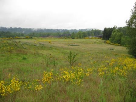 Queen City FarmsThe Queen City Farms Superfund site is located in Maple Valley, Washington. The 324-acre site is immediately south of the King County Cedar Hills Landfill. Previous site uses included a pig farm, an airport, a chemical processing plant and a waste disposal area. From 1955 to the late 1960s, operators disposed of industrial waste in two on-site ponds. Site operators also buried drums containing various industrial wastes around the property. Improper waste disposal practices contaminated site groundwater, surface water and soil. EPA added the site to the Superfund program’s National Priorities List in 1984. Queen City Farms, the current site owner, and The Boeing Company conducted cleanup activities, with oversight from EPA. Responsible parties removed and disposed of wastes and drums, and constructed a cap to secure wastes remaining at the site. Cleanup activities also addressed contamination in surface and groundwater. Long-term groundwater monitoring continues. Today the site is in ecological reuse, supporting wetlands and wooded wildlife habitat areas. A regional composting business uses about 26 acres of the site to recycle organic materials into soil.
For more information:
Silver Mountain Mine
 Silver Mountain MineThe 5-acre Silver Mountain Mine Superfund site is an abandoned silver and gold mine located in Horse Springs Coulee, Washington. From 1902 until the 1960s, the Silver Mountain Mine operated periodically, producing small amounts of silver and gold. From 1980 to 1981, speculators returned to the mine and used chemicals to extract precious metals from the old ore tailings. By July 1981, speculators abandoned the operation. They left behind more than 7,000 tons of cyanide-laced mine tailings and a basin filled with 20,000 gallons of cyanide-contaminated water. In November 1981, the Washington State Department of Ecology (Ecology) investigated the site. Ecology treated the cyanide-contaminated water in 1982. EPA then listed the site on the Superfund program’s National Priorities List (NPL) in 1986. EPA closed the mine entrance and placed the contaminated mine tailings under a protective cap. With the capped area fenced off, EPA revegetated the land around the mine. A partnership between EPA, the State of Washington, the local community and a local rancher resulted in a cleanup that made it possible to once again use portions of the site as grazing land for cattle. In 1997, EPA deleted the site from the NPL. Use of the site for grazing continues. The state continues to perform annual inspections and maintenance of the site’s cap.
For more information:
Spokane Junkyard/Associated Properties
The 16-acre Spokane Junkyard/Associated Properties Superfund site is located in Spokane, Washington. The Spokane Junkyard accepted military surplus items, automobiles, heavy equipment, appliances and electrical transformers from the 1940s until the 1980s. In 1987, an explosive fire destroyed the junkyard. During an investigation, EPA found heavy metals in the soil. EPA listed the site on the Superfund program's National Priorities List (NPL) in 1994. EPA and the site’s responsible parties removed asbestos, contaminated soil and waste, and covered the area. Parties completed these activities in 1997, and EPA deleted the site from the NPL. After deletion, the Bemiss Neighborhood Council worked to identify reuse of the site property could best serve the needs of the Spokane community. The Spokane Youth Sports Association headed a team to plan, fund and build a multi-use sports complex for area youth. The association coordinated redevelopment with EPA to ensure that the site’s remedy remained and was in line with the site’s land use restrictions. Completed in 2002, the Andrew Rypien Field sports complex includes a baseball field and soccer fields. Recipient of the national Phoenix Community Impact Award in 2004 for achievement of excellence in Superfund site reuse, the complex serves over 4,500 neighborhood children.
For more information:
Toftdahl Drums
The 15-acre Toftdahl Drums Superfund site is located in Brush Prairie, Washington. In the early 1970s, the property owner cleaned drums for resale, and reportedly had drums of industrial waste delivered to the property. Unsalvageable drums buried at the site contaminated soil, surface water and groundwater. In 1986, EPA listed the site on the Superfund program's National Priorities List (NPL). EPA and the state investigated the site, removed and disposed of all contaminated soils. After cleanup, EPA deleted the site from the NPL in 1988. Developers have since built eight single-family homes at the former waste site.
For more information:
Vancouver Water Station #1 Contamination
The Vancouver Water Station #1 Contamination Superfund site is located in Vancouver, Washington, just north of Portland. Several well fields on site supply drinking water to approximately 150,000 people throughout the Vancouver area. In 1988, the City of Portland discovered traces of chemical dry-cleaning liquids in wells at the station. An initial inspection to identify the contamination source occurred in 1990, but the source remains undetermined. EPA added the site to the Superfund program's National Priorities List (NPL) in 1994. The City of Vancouver built a groundwater treatment system that uses air-stripping techniques to separate contaminants from the water. Construction reached completion in 1998. The City of Vancouver continues to own and operate a water station at the site with new groundwater wells and storage reservoirs.
For more information:
Wyckoff Co./Eagle Harbor
 Wyckoff Co./Eagle HarborThe Wyckoff Co./Eagle Harbor Superfund site is located on Bainbridge Island, west of Seattle in Puget Sound, Washington. For nearly a century, a wood treatment facility and a shipyard operated at the site. Years of site operations contaminated soil, groundwater and the bottom sediments of the adjacent Eagle Harbor. In 1987, EPA listed the site to the National Priorities List (NPL), and divided the site into three areas: [1] West Harbor is the site of a former shipyard. In this portion of the site, EPA worked with the state to dismantle on-site buildings and remove polluted sediments. Remedial workers placed the most polluted sediments inside a partially submerged containment facility. Crews then paved over this containment facility. Today, this area is used as a maintenance yard by Washington State Ferries. EPA and the State of Washington conduct regular inspections and sampling at the site to ensure the remedy continues to protect the adjacent marine habitat. A trail along the edge of the site is heavily used by runners and cyclists. [2] The former Wyckoff Wood Treatment Plant is located on the south side of Eagle Harbor. Wood was cut and trimmed, preserved with creosote, and sold for use as railroad ties, utility poles, pier pilings and other outdoor structures. The soil and groundwater at the site became heavily contaminated with creosote and other chemicals over nearly 100 years of operations. Today, a steel sheetpile around the outer edge of the site prevents the contamination from moving into Eagle Harbor. Groundwater extraction and treatment prevents contamination from moving down into the lower aquifer below the site. EPA has been studying additional cleanup options, and will propose a new cleanup plan for this area in late 2015. Once the cleanup is complete, the site will be incorporated into the adjacent city park, providing more than 15 acres of open space with spectacular views of Puget Sound and the Seattle skyline. The City of Bainbridge Island purchased the site from EPA in 2007 for use as a park. The beach west of the former treatment plant and the hillside behind it were the first areas to be converted to park land, and are now part of Pritchard Park. West beach is a popular recreational area used by beachgoers, dog-walkers, kayakers and standup paddle boarders. The hillside above the beach is wooded and features a network of hiking trails. The westernmost portion of the park is now the Bainbridge Island Japanese American Exclusion Memorial. Bainbridge Island was home to many Japanese Americans, who were forcibly removed from their homes and sent to internment camps during World War II. The Memorial is located on the site of a former ferry dock, where detainees boarded boats to Seattle on their way to the camps. The Memorial includes several pathways through the site and a memorial wall 276 feet in length – one foot for each relocated resident. [3] East Harbor includes more than 70 acres of bottom sediments and beaches on the south side of Eagle Harbor. The bottom sediments became heavily contaminated with creosote released from the former wood treatment plant. EPA, working with the U.S. Army Corps of Engineers, obtained clean sand from a river dredging project and used the sand to bury, or “cap” contaminated portions of the Harbor in 1994. Several extensions were added to the cap in later years. EPA regularly monitors the condition of the cap and in 2012, found that a portion of the cap in the middle of the harbor has eroded, exposing the contaminated sediment below it. A repair is being planned with construction scheduled in 2016. The remainder of the cap is in good condition, and it provides clean habitat that supports a diverse population of fish, crabs, clams, and shorebirds.
For more information:
Yakima Plating Co.
The 2-acre Yakima Plating Company Superfund site is located in Yakima, Washington. Since 1962, Yakima Plating has electroplated bumpers for cars and other objects on the property and disposed of wastewaters in an on-site drain field. Operations contaminated groundwater and soil on site. In 1989, EPA listed the site on the Superfund program’s National Priorities List (NPL). In 1991, EPA funded and conducted an early action removal and disposed of contaminated soil. As a result, EPA selected a “no further action” remedy for the site and deleted the site from the NPL in 1994.
For more information: