Superfund Sites in Reuse in Maine
If you are having trouble viewing the map in your browser, click the 'View larger map' link below
Eastern Surplus
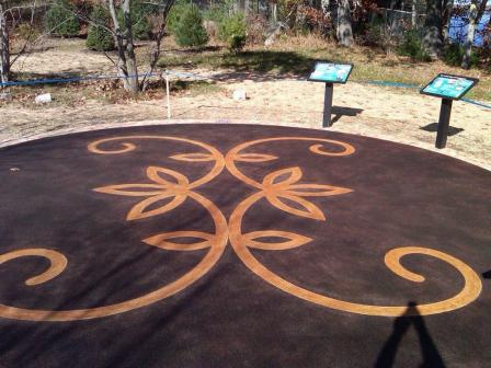 Eastern SurplusThe Eastern Surplus Company Superfund site occupies about five acres of land along Meddybemps Lake and Dennys River in Meddybemps, Maine. Eastern Surplus operated as an army surplus and salvage retailer from 1946 until the early 1980s. An inspection of the facility in 1984 noted contamination. The contamination threatened local active fisheries and spawning areas. EPA placed the site on the Superfund program’s National Priorities List (NPL) in 1996. EPA removed and disposed of contaminated soil and materials off site, and began operating a groundwater treatment system in 2000. Two processes have been put in place to improve the groundwater remedy. These include the process of adding chemicals to groundwater to create conditions necessary to transform or remove contaminants and the use of living organisms to break down contaminants. The groundwater treatment system is currently offline while EPA and the Maine Department of Environmental Protection evaluate the effects of these processes. Investigations during cleanup at the site found Native American artifacts. EPA determined the northern part of the site was eligible for the National Register of Historic Places. This area, named N’tolonapemk (“Our Ancestor’s Place”) by the Passamaquoddy Tribe, is now a major archaeological research site. In 2012, parties constructed a commemorative patio and pathway for the area. A seasonal home occupies the southern part of the site. EPA anticipates continued residential, light commercial and agricultural use of the southern area.
For more information:
Eastland Woolen Mill
The 22-acre Eastland Woolen Mill Superfund site is located on Main Street in the heart of Corinna, Maine. A textile mill operated at the site from 1909 until 1996. Disposal practices resulted in contamination of sediments in the East Branch of the Sebasticook River, soil and groundwater. In 1999, EPA placed the site on the Superfund program’s National Priorities List (NPL) and began cleanup activities at the site. EPA’s close coordination with the local community ensured the productive reuse of the optimally-located property. In 2001, EPA’s Superfund Redevelopment Initiative provided a grant to the Town of Corinna for a community-based reuse assessment and reuse plan. Based on these plans, a 20-unit senior housing facility opened on part of the site in 2006. EPA, the Town of Corinna and the State of Maine also relocated the historic Odd Fellows Building to the site and the building currently operates as a country store and restaurant. The site is also home to the Town of Corinna War Memorial, a community bandstand and a community boardwalk through a greenspace along the river. The remainder of the site incorporates commercial, residential and mixed-use development. In 2012, EPA took 80 percent of the site’s land area off the NPL after determining cleanup for the areas was complete. The area removed from the NPL includes several properties currently available for reuse. Site stakeholders hope the deletion will add further clarity to the site’s cleanup status and help create even more reuse.
For more information:
- Redevelopment of the Eastland Woolen Mill Superfund Site (PDF)(1 pg, 80 K, About PDF)
- Superfund Site Profile Page
Loring Air Force Base
Located in Limestone, Maine, the Loring Air Force Base served as a major Strategic Air Command (SAC) base for the U.S. Air Force for over 40 years until its closing in 1994. The Base housed a bomber wing and had SAC’s largest capacity for weapons and fuel storage. EPA added the site to the National Priorities List in 1990 due to contamination from waste oils, fuels cleaned from aircraft and vehicles, spent solvents, polychlorinated biphenyls (PCBs), pesticides and three on-site landfills. Following the completion of cleanup activities, stream restoration activities took place, returning the stream to its natural condition. Later, the Air Force donated the site to the Loring Development Authority. The Loring Development Authority worked with the Air Force and EPA to establish the Loring Commerce Center, an industrial complex, aviation center and business park, on the 8,700-acre site. Private businesses and federal agencies within the commerce center provide employment and income for the surrounding community. Tax credit and exemption programs, such as the Job and Investment Tax Credit and the Research Expense Credit, offer additional incentives to potential new tenants. Redevelopment at the site serves as a success story for other Base Realignment and Closure (BRAC) facilities.
For more information:
Pinette's Salvage Yard
 Pinette's Salvage YardThe 12-acre Pinette’s Salvage Yard Superfund site is located about one mile southwest of Washburn, Maine. In 1979, three electrical transformers broke at the site and fluids containing hazardous chemicals spilled directly onto the ground. The fluids moved through the soil, contaminating groundwater and surface water. In 1982, EPA placed the site on the Superfund program’s National Priorities List (NPL). In 1983, as part of a removal action, EPA removed and disposed of some contaminated soil off site. EPA’s cleanup plan for the site addressed contaminated groundwater and the remaining contaminated soil. After successful cleanup, EPA deleted the site from the NPL in 2002. EPA’s cleanup plan allowed part of the site to continue operation as a vehicle repair and salvage yard throughout cleanup activities. Today, the vehicle repair and salvage yard business still operates on the site. Business activities include the storage and dismantling of damaged vehicles and the sale of recovered auto parts.
For more information:
Saco Municipal Landfill
The Saco Municipal Landfill Superfund site covers about 90 acres in Saco, Maine. The City of Saco has owned and operated the on-site landfill since 1960. The site includes four distinct disposal areas. Chemicals and wastes contaminated soil and groundwater at the site. In 1990, EPA placed the site on the Superfund program’s National Priorities List (NPL). Under EPA and Maine Department of Environmental Protection (Maine DEP) oversight, the City of Saco cleaned up the site. Cleanup activities included removing waste, removing and placing contaminated sediment under a cap, monitoring of natural processes to clean up groundwater, and restricting land use. In 1998, the City of Saco began planning for the site’s reuse. EPA approved a plan to improve the wildlife habitat in the former gravel and sand pit in one of the disposal areas at the site. In 2001, the City graded the area, established a vegetative cover, and constructed a series of wetland areas next to Sandy Brook. In 2003, the City completed plans to develop a community recreation area for hiking, biking, ice skating and soccer. The City completed construction of two soccer fields for elementary and middle school children. Reuse planning is underway to use other unused portions of the site for additional town facilities.
For more information: