Superfund Sites in Reuse in California
If you are having trouble viewing the map in your browser, click the 'View larger map' link below
Advanced Micro Devices, Inc.
The former Advanced Micro Devices, Inc. (AMD) 901/902 Thompson Place Superfund Site covers six acres in Sunnyvale, California. Between 1969 and 1992, AMD designed and fabricated semiconductor devices at two buildings at the site. The buildings were vacated by AMD in 1992 and remained vacant until the property was sold and redeveloped in 2007. Site investigations, which began in 1982, disclosed soil and groundwater contaminated with volatile organic compounds. EPA placed the site on the Superfund program’s National Priorities List (NPL) in 1986. Cleanup included removing soil contamination and treating contaminated groundwater. Groundwater treatment and monitoring are ongoing. In 2007, a developer bought the property and demolished the two former AMD buildings. The new property owner developed the former AMD facility area as a self-storage facility. Several other commercial and light manufacturing businesses also operate on the site.
For more information:
Aerojet General Corp.
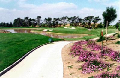
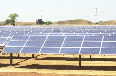 Aerojet General Corp.The Aerojet General Corp. Superfund site covers about 5,900 acres near Rancho Cordova, 15 miles east of Sacramento, California. Since 1953, Aerojet and its subsidiaries have researched, designed and manufactured rocket engines and formulated chemicals on site. Disposal and operating practices led to soil and groundwater contamination. EPA listed the site on the Superfund program’s National Priorities List (NPL) in 1983. Since then, Aerojet has worked to contain and address contaminated groundwater using multiple groundwater pump-and-treat systems. Aerojet is also investigating how to further prevent the spread of contaminants and to more fully clean up of soil and groundwater contamination sources. In 2008, Aerojet started plans to convert a portion of its facility into a solar farm to help power the site’s extensive groundwater cleanup program. Aerojet viewed this as an opportunity to reduce the company’s carbon footprint and improve energy use. Installed in 2009 and 2010, 22 solar arrays now generate 6 megawatts of power. The electricity produced provides more than 20 percent of the energy needed to power the site’s groundwater cleanup program. Aerojet continues to operate on the site. Tenants also use the site for a variety of office, commercial and light industrial activities. Aerojet has begun the planning process to reuse portions of the site. Reuse will include a mixed-use development with residential, commercial and industrial uses.
For more information:
- Redevelopment of the Aerojet General Corporation Superfund Site (PDF)(1 pg, 155 K, About PDF)
- Green Remediation and Utility-Scale Solar Development: The Aerojet General Corporation Superfund Site and Sacramento County, California (PDF) (14 pp, 3.5 MB)
- Superfund Site Profile Page
Applied Materials
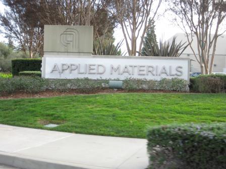 Applied MaterialsThe 9-acre Applied Materials Superfund site (also known as the Applied Materials -Building 1 (AM1) Facility) is located in Santa Clara, California. A large industrial building occupies most of the site. Applied Materials began semiconductor wafer manufacturing operations in the building in 1974. In 1983, monitoring wells on the site indicated the presence of contamination in site soil and groundwater. Leaking pipes leading to underground tanks may have resulted in site contamination. In 1984, Applied Materials installed a system to pump and treat contaminated groundwater. In 1985, Applied Materials removed underground storage tanks and some of the surrounding soil. In 1987, EPA added the site to the Superfund program’s National Priorities List (NPL). In 1993, potentially responsible parties determined that the groundwater treatment system would address the contamination under the building. Groundwater treatment continued through 2002. Groundwater monitoring continues. In 2003, Applied Materials ended research and manufacturing activity on site and converted the building to offices and educational facilities.
For more information:
Atlas Asbestos Mine
 Atlas Asbestos MineThe Atlas Asbestos Mine Superfund site is located in western Fresno County, California. The site includes the 140-acre Atlas Mine Area and a 107-acre area in the City of Coalinga (City OU). The Atlas Mine Area includes the asbestos mine, a processing mill, support buildings and extensive asbestos mine tailings The City OU area operated as an asbestos milling, manufacturing, storage and transportation center. The site shares the City OU with the nearby Coalinga Asbestos Mine Superfund site. From 1957 to 1977, milling operators mined the Coalinga and Atlas asbestos mines and shipped asbestos ore to the City OU for storage. Operations released asbestos into the soil, groundwater and air. EPA added the site to the Superfund program’s National Priorities List (NPL) in 1984. Cleanup activities, conducted primarily between 1994 and 1996, included building stream diversions and sediment trapping dams, stabilizing the slopes of the waste piles and limiting access to the site by erecting fences. Deed restrictions protect private property. Cleanup efforts at the City OU included demolishing the storage buildings, removing contaminated soil and debris, and capping the site with an impermeable clay cover. City OU cleanup activities took place primarily between 1990 and 1993. Redevelopment activities within the City OU have included a K-Mart department store, a 43-unit apartment complex and a 47-lot subdivision.
For more information:
Barstow Marine Corps Logistics Base
The Barstow Marine Corps Logistics Base Superfund site covers 5,687 acres east of Barstow, California. The site consists of three areas: the Nebo area, the Yermo area and the Rifle Range. The base was established at the Nebo location in 1942, when the U.S. Navy transferred command to the U.S. Marine Corps. The base has two major functions: providing equipment maintenance, repair, overhaul and rebuilding, and receiving, storing, maintaining, issuing and shipping materials. Vehicle-related and war surplus wastes made up the majority of historically site-generated wastes. Vehicle-related wastes include waste oils, grease, hydraulic fluids, fuels, battery acids, bilge waters and antifreeze. The maintenance, rebuilding and preservation of vehicles in the repair division generated a majority of the site’s industrial wastes. Some hazardous or suspected hazardous wastes were contained in war surplus materials received at the base, including ammunition, various sources of low-level radiation and chemicals such as pesticides, herbicides and raw materials. Investigations by the U.S. Marine Corps discovered 38 separate areas of contamination on the base, including contamination of site ground water with volatile organic compounds (VOCs) and soil with contaminants including VOCs and heavy metals. In response to the discovery of area ground water contamination, an alternate drinking water supply was provided for personnel on the base. EPA placed the site on the National Priorities List (NPL) in 1989. Site cleanup activities included the excavating and treating contaminated soil and sludge, ensuring the integrity of surface features to control water infiltration, and containing the on-site landfill under a concrete cap. Continued ground water monitoring and the installation of fencing around the site ensure the effectiveness of the site’s remedy. Today, the Barstow Marine Corps Logistics Base supports U.S. Marine forces west of the Mississippi, as well as forces located in the Far East and Asia. The Nebo area currently functions as base headquarters and is the main facility for administration, storage, recreational activities, shopping and housing functions. The Yermo Annex is primarily a storage and industrial complex and the third site area consists of the base’s rifle and pistol ranges.
For more information:
Beckman Instruments (Porterville Plant)
The Beckman Instruments (Porterville Plant) Superfund site is located in Porterville, California. The 160-acre site includes the 12-acre Beckman plant property and other nearby privately-owned commercial, agricultural and residential properties. The company manufactures printed circuit boards and electronic instrument parts at the facility. From 1974 until 1983, facility operators disposed of wastes in an evaporation pond on site. This pond is the most likely source of groundwater contamination in the area surrounding the Beckman facility. Investigators also identified lead contamination in the soil. In 1985, Beckman began operating a groundwater pump-and-treat system. EPA added the site to the Superfund program’s National Priorities List (NPL) in 1986. In 1989, cleanup addressed contaminated soil and expanded the groundwater treatment system. In 2005, EPA agreed to discontinue use of the groundwater treatment system and allow the groundwater to recover naturally. Groundwater monitoring continues. The plant continues to operate and there is continued agricultural and residential use. EPA’s cleanup plan enabled Beckman Instruments and the nearby commercial companies to remain open for business, retaining jobs and income in the community as well as maintaining a safe working environment.
For more information:
Camp Pendleton Marine Corps Base
The 125,000-acre Camp Pendleton Marine Corps Base Superfund site is located on the northern edge of San Diego, California. Established in 1942, the base serves as a training facility for the U.S. Marine Corps and supports about 36,000 military personnel and 4,600 civilian employees. Military family housing and recreational areas occupy portions of the base as well. Throughout the base’s history, operators improperly disposed of raw sewage, burned solid waste, and mishandled various hazardous substances. Together, these actions created contaminated areas scattered throughout the 125,000-acre property. Between 1984 and 1988, the U.S. Navy assessed the base and identified soil and ground water requiring cleanup from decades of improper waste disposal practices. EPA added the site to the National Priorities List (NPL) in November 1989. From 1995 to 1997, the U.S. Marine Corps removed and treated contaminated soil from the base. They then installed several monitoring wells. The ground water supply, which provides drinking water for the entire base, currently meets drinking water standards. In addition, the U.S. Marine Corps built a protective cap over the base’s solid waste landfill. In 2010, Kyocera Solar constructed a solar array on the landfill. The alternative energy project generates up to 2.7 megawatts of power for on-site use. The U.S. Marine Corps continues to use the base as a training center.
For more information:
Coast Wood Preserving
The 8-acre Coast Wood Preserving (CWP) Superfund site is located 3 miles south of Ukiah in northern California. Historically, CWP facility operators used a solution of sodium dichromate, copper sulfate and arsenic acid to pressure-treat and preserve wood products. Dripping and spillage of the chemical solution contaminated the soil and groundwater on and off site. In 1983, CWP began treating groundwater. That same year, EPA added the site to the Superfund program’s National Priorities List (NPL). Since the site’s listing, CWP has paved over soils to prevent water penetration, has started groundwater extraction and treatment and has excavated contaminated soil for off-site disposal. In 2004, CWP began using a different chemical solution for its wood-treating operations. CWP continues to operate on the site. Long-term monitoring of site groundwater continues.
For more information:
Crazy Horse Sanitary Landfill
The 160-acre Crazy Horse Sanitary Landfill (CHL) Superfund site is located about 5 miles from the City of Salinas, California. In the 1970s, a local manufacturing plant disposed of large quantities of rubber materials, carbon black, other fillers, oils and mixed solvents in the landfill. These actions contaminated the groundwater. In 1990, EPA listed the landfill area on the Superfund program’s National Priorities List (NPL). Following the site’s listing, the Salinas Valley Solid Waste Authority implemented a system to clean up contaminated groundwater, and additional remediation is continuing under Regional Water Quality Control Board oversight. The landfill stopped accepting waste in 2009 and completed formal closure in 2014. The City installed a cover that will enable the future use of photovoltaic (PV) technology on the landfill. Beginning in 1987, Pacific Energy, and then Covanta Energy, operated a landfill gas collection system for electricity generation on the site which was later dismantled. The National Renewable Energy Laboratory completed a feasibility study evaluating renewable energy production at the site as part of the RE-Powering America’s Land Initiative. Additional evaluations of potential solar energy generation are in progress.
For more information:
CTS Printex, Inc.
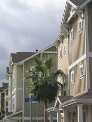 CTS Printex, Inc.The CTS Printex, Inc. Superfund site is located in Mountain View, California. From 1966 to 1985, Printex Corporation (now CTS Printex) manufactured printed circuit boards on a 5.5-acre property. Waste management practices resulted in soil and groundwater contamination. CTS Printex began cleanup activities in 1985. In 1990, EPA added the site to the Superfund program’s National Priorities List (NPL). The site includes the former facility property and an area of impacted groundwater extending beyond the facility boundary. CTS Printex cleaned its waste collection system, removed contaminated soil and treated the underlying groundwater. In 2006, a developer acquired the former CTS Printex property and completed a residential townhome development in 2010. EPA worked closely with CTS Printex and the site developer to ensure the site could safely support residential development. Initial groundwater treatment successfully removed much of the contamination. In 2011, EPA required additional actions to clean up groundwater contamination, as well as subsurface vapors that might enter into buildings located above contaminated groundwater. CTS Printex plans to conduct a remedial design investigation in 2015 followed by design and construction of the new groundwater remedy north of Plymouth Street to address the remaining groundwater contamination at the site.
For more information:
Del Amo
 Del AmoThe 280-acre Del Amo Superfund site is located in Los Angeles, California, in an area known as the Harbor Gateway. The Del Amo synthetic rubber plant operated from 1943 until 1972. It consisted of three separate plants. Manufacturing generated various sludge wastes and wastewaters. Site operators deposited some of these wastes in unlined pits and evaporation ponds on the property. Manufacturing operations also resulted in releases of hazardous substances to the soil at various locations throughout the site. In the 1970s, most of the site was transformed into an industrial park. In 1981, the state required the cleanup of soil from one of the waste pits. In 1997, EPA proposed adding the site to the Superfund program’s National Priorities List (NPL), and the site was added to the NPL in 2002. Cleanup efforts to date have included capping the waste pits and extracting contaminated vapors from the soil beneath the waste pits, conducting soil removal actions in conjunction with construction and redevelopment projects throughout the site, and construction of a groundwater extraction and treatment system. Soil cleanup beneath the waste pits continues. EPA is working with potentially responsible parties and state agencies to initiate groundwater treatment. All but about 10 of the 280 acres that make up the site have been developed for industrial and commercial uses, including light manufacturing, warehousing and offices.
For more information:
- Reuse and the Benefit to Community: Del Amo Case Study (2013) (PDF) (44 pp, 1.5 MB, About PDF)
- Cleanup, Continued Use and Redevelopment in a Thriving Business Park: The Del Amo Superfund Site in Los Angeles, California (PDF)(14 pp, 1.3 MB)
- Superfund Site Profile Page
Del Norte Pesticide Storage
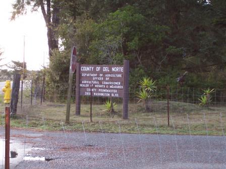 Del Norte Pesticide StorageThe 1-acre Del Norte Pesticide Storage Superfund site is located just north of Crescent City, California. From 1970 to 1981, Del Norte County operated a temporary pesticide storage area at the site and accepted containers from local agricultural industries. In the process, operators released contaminated waste and rinse water into an unlined basin. The contaminated shallow groundwater threatened the residences, farmland and private wells surrounding the site. In 1984, EPA added the site to the Superfund program’s National Priorities List (NPL). EPA removed contaminated soils and installed a water treatment system in 1989. The system removed about 95 percent of the contamination within the first four years of treatment. The spread of the low levels of the one remaining contaminant was stopped by 2002, and EPA removed the site from the NPL in September 2002. The 2015 Five-Year Review shows that the groundwater now is close to drinking water quality. The Del Norte County Agriculture Department office and related facilities are now located at the site. Del Norte County has considered plans to use parts of the site to support land use growth in the surrounding area.
For more information:
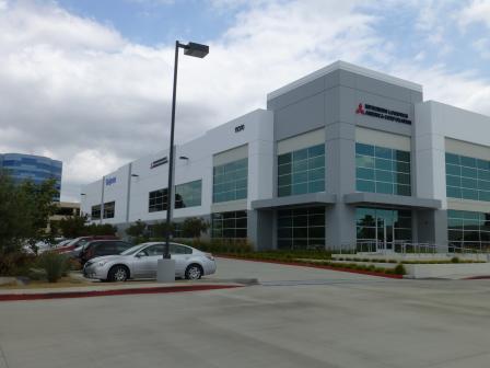
Fairchild Semiconductor Corp. (Mountain View Plant)
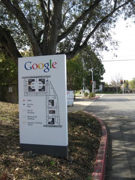 Fairchild Semiconductor Corp. (Mountain View Plant)The 56-acre Fairchild Semiconductor Corp. (Mountain View Plant) Superfund site is located in Mountain View, California. Fairchild Semiconductor operated at the site from 1968 to 1981. The site is part of the Middlefield-Ellis-Whisman (MEW) Study Area, which also includes the Raytheon Company Superfund site, the Intel Corp. (Mountain View Plant) Superfund site, as well as the portions of the former Naval Air Station (NAS) Moffett Field Superfund site where MEW and Navy groundwater contamination have mixed. In the 1960s and 1970s, several industrial companies involved in semiconductor, electronics, and other manufacturing and research activities contaminated area soil and groundwater. Operations at the former NAS Moffett Field also resulted in groundwater contamination. Between 1986 and 1991, EPA added these four sites to the Superfund program’s National Priorities List (NPL). In 1989, EPA began cleanup to address soil and groundwater contamination across the MEW Study Area. Soil cleanup actions are complete. Groundwater treatment and monitoring continue. Efforts to address subsurface vapor intrusion into buildings are also underway. A prospective purchaser agreement between EPA and a developer helped facilitate the purchase and redevelopment of more than 38 acres of the Fairchild Semiconductor site by 1998. Google, Inc. headquarters now occupies a number of properties at the Fairchild Semiconductor site. Plans are also underway to construct a residential development on part of the site.
For more information:
Fairchild Semiconductor Corp. (South San Jose Plant)
The 22-acre Fairchild Semiconductor Corp. (South San Jose Plant) Superfund site is located about 9 miles southeast of downtown San Jose, California. The site is a former semiconductor manufacturing facility. The facility operated from 1977 until 1983. Consistent with industry practice at the time, manufacturing operations required the use and storage of industrial solvents. In 1981, Fairchild discovered that an underground organic solvent waste tank had failed, impacting soil and groundwater. Since that time, Fairchild has completed several cleanup actions that have cleaned up soil and groundwater. In 1989, EPA added the site to the Superfund program’s National Priorities List (NPL). EPA approved Fairchild’s completed and current cleanup activities. Site cleanup included soil removal, construction of a slurry cut-off wall surrounding the site, a pump-and-treat system addressing on-site and off-site groundwater, soil vapor extraction and treatment, groundwater monitoring, and implementation of institutional controls. With regulatory agency approval, the pump-and-treat system shut down in 1998, and Fairchild has continued to monitor groundwater since then. EPA is currently allowing groundwater to recover using natural processes. The site was unoccupied from 1983 until it was redeveloped as the Bernal Plaza shopping center between 1998 and 2000. The shopping center includes retail shops, restaurants and parking.
For more information:
Firestone Tire & Rubber Co. (Salinas Plant)
The 256-acre Firestone Tire & Rubber Co. Superfund site is located in an agricultural area in Salinas, California. The Firestone Tire & Rubber Company used the facility for tire manufacturing from 1963 until 1980. During this period, factory operators used a variety of chemicals that contaminated the soil and groundwater. After the facility closed, Firestone conducted interim cleanup measures, including constructing and operating a groundwater treatment system and removing contaminated soil. In 1987, EPA placed the site on the Superfund program’s National Priorities List (NPL). EPA required Firestone to expand its groundwater treatment system. Successful groundwater treatment met the required standards. After the tire manufacturing facility closed, redevelopers built the Firestone Business Park at the site. The commercial park provides space for several small and medium-size businesses. EPA deleted the site from the NPL in 2005.
For more information:
Fort Ord
The 28,000-acre Fort Ord Superfund site is located near Monterey Bay in northwestern Monterey County, California, about 80 miles south of San Francisco. A former military installation, the site is next to the cities of Seaside, Sand City, Monterey and Del Rey Oaks to the south and Marina to the north. Past practices at Fort Ord resulted in contaminated ground water, soil and sludges. Unexploded ordnance, munitions and explosives may also pose safety hazards. The U.S. Army began investigation and cleanup activities in 1986. EPA added Fort Ord to the National Priorities List (NPL) in 1990. That same year, the U.S. Army signed a Federal Facility Agreement with EPA and the state to investigate and clean up the site. Although the U.S. Army is leading the cleanup across most of the site, the Fort Ord Reuse Authority is cleaning up about 3,500 acres of the site under a private cleanup effort. Parties have completed a number of cleanup actions and continue to carry out others. In 1991, the federal government selected Fort Ord for decommissioning and formally closed the post in 1994. Reuse at the former military base includes the California State University, Monterey Bay campus; a wetlands preserve; public golf courses; the local municipal airport; a Veterans Transition Center; and Fort Ord Dunes State Park. Local residents are also using other portions of the site for mountain biking, hiking, dog training, bird watching and youth education activities. The U.S. Army continues to operate an annex and reserve center, which provides a full set of support services for U.S. Army personnel, on a small portion of the site.
For more information:
Fresno Municipal Sanitary Landfill
 Fresno Municipal Sanitary LandfillThe 145-acre Fresno Municipal Sanitary Landfill Superfund site is located 4 miles from Fresno, California. The City of Fresno began operating the landfill in 1935. While conducting tests in 1983, the California Department of Health Services found that methane gas and vinyl chloride gas had migrated from the landfill to the surrounding areas. Testing also found that contaminated groundwater had migrated off site to several private residential wells located nearby. The City closed the landfill in 1989, the same year EPA added the landfill to the Superfund program’s National Priorities List (NPL). In 1990 and 1991, the City removed contaminated landfill gas spreading from the site. The City capped the landfill and constructed landfill gas control and surface water management systems. The City also constructed a groundwater treatment facility. The systems continue to operate. In 2001, the City redeveloped part of the site into the Fresno Regional Sports Complex. The complex includes soccer and softball fields. Constructing the sports complex at the same time as cleanup allowed the reuse planning to be effectively coordinated with ongoing remediation.
For more information:
Frontier Fertilizer
The 8-acre Frontier Fertilizer Superfund site is located near the City of Davis, California. Operations in the 1970s and 1980s consisted of pesticide and herbicide storage, mixing and delivery. These activities contaminated site soils, as well as groundwater, the primary drinking water source in the area. EPA listed the site on the Superfund program’s National Priorities List (NPL) in 1994. Today, the site serves as a prime example of innovative green remediation and renewable energy at a Superfund site. For the first time nationwide, solar energy is providing all of the power for a Superfund groundwater cleanup. EPA first installed solar panels at the site in 2007. The initial panels partially offset the site groundwater treatment system’s electrical power needs, but could not fully power the remedy. In 2010, $350,000 in American Recovery and Reinvestment Act funds facilitated an expansion of the solar energy system, which now provides 100 percent of the power for the groundwater treatment system. The new solar panels cover half an acre, resulting in a green cleanup method that generates plenty of solar energy and offsets non-renewable energy use. The installation and operation of the new solar panel system resulted in a $15,000 reduction in the site’s overall annual energy costs and a reduction of more than 54 metric tons of annual carbon dioxide emissions. Heating of the source area, completed in October 2012, will accelerate the site’s estimated cleanup duration by about 120 years. This will reduce the time for achieving groundwater cleanup from 150 years to 30 years. To further “green” the site, the project team is also evaluating options to reuse treated groundwater for local irrigation needs.
For more information:
Hewlett-Packard (620-640 Page Mill Road)
The Hewlett-Packard (620-640 PAGE MILL ROAD) Superfund site in Palo Alto, California, housed optoelectronic equipment manufacturing facilities on 10 acres from 1962 to 1986. In 1981, at least 300 gallons of waste solvents leaked from a buried storage tank. The company excavated the tank and about 100 cubic yards of contaminated soil in 1981 and transported the materials to a hazardous waste facility. Since 1982, the company has been pumping and treating contaminated ground water. EPA added the site to the National Priorities List (NPL) in 1990, because of contaminated ground water and soil. Between 1987 and 1992, Hewlett-Packard excavated and disposed of about 11,000 cubic yards of contaminated soil from the site. Hewlett-Packard treated soil vapors from 1994 to 1997. Stanford University owns the primary site property. After stopping operations in 1986, Hewlett-Packard began redevelopment in 1992 with the construction of a new office building. Hewlett-Packard sold the building and associated land lease in May 2007. The current owner of the building and land lease is NOP 650 Page Mill, LLC. A law firm currently occupies the building.
For more information:
Industrial Waste Processing
 Industrial Waste ProcessingThe Industrial Waste Processing (IWP) Superfund site occupies 0.5 acre in the Town of Pinedale, California. From 1967 to 1981, IWP operated a chemical recycling facility for petroleum residues recovered from natural gas field pipelines and solvents generated by the paint and ink industries. The facility also recovered lead solder and zinc from the metal can manufacturing industry. IWP also distributed various chemical solvents for Ashland Oil. After 1983, IWP used the site to store chemicals and equipment. Improper storage and handling practices are the main source of contamination. In 1988, EPA removed hazardous liquids and contaminated soils from the site. EPA added the site to the Superfund program’s National Priorities List (NPL) in 1990 after investigators found that contamination remained in the soil. In 1999, potentially responsible parties cleaned up the site. Cleanup involved removing and disposing of the contaminated soils, filling the excavated areas with clean material and testing to confirm cleanup. In 2001, the site owner sold the site to Pacific Tent & Awning, a manufacturer of fabric awnings and accessories. The company built an 8,192-square-foot warehouse and office facility that covers about 80 percent of the site area. Asphalt, concrete and a limited amount of landscaping cover the rest of the site. EPA continues to monitor and evaluate the site.
For more information:
Intel Corp. (Santa Clara III)
 Intel Corp. (Santa Clara III)The 4-acre Intel Corp. (Santa Clara III) Superfund site is located in Santa Clara, California. Intel Corporation (Intel) operated a plant that performed quality control of chemicals and tested microprocessors from 1976 until 2008. Regulators first detected groundwater contamination at the site in 1982. In 1985, Intel constructed and began operating a groundwater treatment system to remove the contaminated groundwater. In 1986, EPA added the site to the Superfund program’s National Priorities List (NPL) because the groundwater contamination threatened the drinking water supply source for Santa Clara Valley residents. Intel continued to operate the groundwater treatment system until 1994. Only a limited area of groundwater contamination remains, and the Record of Decision was amended in 2010 to implement monitored natural attenuation. From 2008 to mid-2010, the site was unoccupied. Recently, Vantage Data Centers purchased the property. The company redeveloped the site, which now functions as a data storage center.
For more information:
Intel Magnetics
 Intel MagneticsThe 3-acre Intel Magnetics Superfund site is commonly referred to as the Intel Magnetics/Micro Storage Corporation or IM/MSC site. The site is located in Santa Clara, California. Past activities at the IM building and nearby MSC building resulted in shallow groundwater contamination. Site investigations identified two main but distinct sources of contamination: the IM facility underground waste-solvent storage tank and the chemical storage area at MSC. EPA added the IM site to the Superfund program’s National Priorities List (NPL) in 1986. In 1988, EPA included the MSC site with the IM site as one combined Superfund site on the NPL. A groundwater treatment system operated on the site from 1986 until 1995. Groundwater monitoring continues. Microsemi RFI and Micro-Chem currently operate at the site, and use the former IM and MSC buildings for administration and high-tech related manufacturing.
For more information:
Intersil Inc./Siemens Components
The Intersil Inc./Siemens Components Superfund site is located in Cupertino, California. Intersil, Inc. and Siemens Components manufactured semiconductors for several years on two nearby locations covering 15 acres. Investigations conducted in the 1980s as part of the California Regional Water Quality Control Board's underground storage tank leak detection program found contaminants in soil and groundwater. The contamination may have resulted from localized spills and from leaking underground storage tanks and piping from the two companies. At the Siemens facility, operators used four underground tanks to store waste solvents. At the Intersil facility, possible sources of contamination included waste neutralization systems and concrete scrubber pit sumps. Intersil stopped manufacturing at the site in 1988, and Siemens stopped manufacturing in mid-1990s. EPA added the site to the National Priorities List (NPL) in 1990. Cleanup activities included the removal and disposal of about 182 cubic yards of soil, soil vapor extraction and treatment at both facilities, and groundwater extraction and treatment at both facilities and off site. The building on the former Intersil property was demolished in the 1990s and has been replaced by a two-story commercial building. Kaiser Permanente now occupies the building on the former Siemens property and uses it as part of a medical facility. Indoor air samples collected at the former Intersil and Siemens facilities and in the residential and commercial Off-Site Study Area provide evidence that there is no risk associated with constituents of concern reported in subsurface soil or groundwater. Groundwater extraction and treatment continues. Monitoring of groundwater will continue to verify the contaminants remain within health-based levels.
For more information:
J.H. Baxter & Co.
The 205-acre J.H. Baxter & Co. Superfund site is located in the City of Weed in northern California, less than 40 miles south of the Oregon border. J.H. Baxter & Co. and Roseburg Forest Products own the site. Various companies have operated at the site, conducting wood treatment and related activities continuously since 1937. Wood-treating operations resulted in contaminated groundwater, surface water, soil and sludge, as well as contamination of a nearby creek. In 1986, potentially responsible parties (PRPs) installed a fence to limit site access. In 1989, EPA placed the site on the Superfund program’s National Priorities List (NPL). In the late 1990’s, PRPs installed a fence around the site to prevent direct contact with site contamination. Although much of the cleanup is complete, groundwater treatment and monitoring continues. J.H. Baxter & Co. continues to operate a wood treatment plant on the site. Roseburg Forest Products operates a lumber mill and veneer plant. Pacific States Treating also leases a portion of the site.
For more information:
Jibboom Junkyard
 Jibboom JunkyardThe 9-acre Jibboom Junkyard Superfund site is located in Sacramento, California along the Sacramento River. From 1950, Associated Metals Company used the site for metal salvaging until 1965, when the California Department of Transportation bought the property to build an elevated freeway. Salvaging activities left the site contaminated with heavy metals and other chemicals. EPA added the site to the Superfund program’s National Priorities List (NPL) in 1983. From 1985 until 1987, cleanup included removing and disposing of contaminated soil, and replacing it with clean soil. Soil cleanup prevented contamination of groundwater, and EPA deleted the site from the NPL in 1991. U.S. Interstate 5 covers 7 acres of the site. The remainder of the site, between the active elevated freeway and the Sacramento River, now houses the Robert T. Matsui Waterfront Park. The City began designing the current park in the 1990s, noting the site’s aesthetic potential and convenient central location along the Sacramento River Parkway bicycle trail. The City of Sacramento completed the park in 2007. The park includes an arc-shaped pedestrian walkway linking a fountain plaza to a smaller pedestrian overlook on a pier with interpretive signage. The park has an open green space area, planted with native grasses, trees and vegetation for picnicking and benches for viewing the river. Future plans for the site include additional park and picnic areas. Major urban development is planned for the former rail yards just to the east, with even greater benefit of the Matsui Waterfront Park.
For more information:
- Redevelopment of the Jibboom Junkyard Superfund Site (PDF)(1 pg, 168 K, About PDF)
- Superfund Site Profile Page
Lorentz Barrel & Drum Co.
The 7-acre Lorentz Barrel & Drum Co. Superfund site is located in San Jose, California. The site includes a former drum recycling facility that operated from 1947 until its closing in 1987. During that time, the facility accepted over 2 million drums. The facility emptied, cleaned, resealed, repainted and resold the used drums, which typically contained residues of solvents, acids and caustic chemicals. Contamination of soils, groundwater and a nearby creek resulted from the improper handling of wastes in the drums as well as waste generated during the recycling process. EPA added the site to the Superfund program’s National Priorities List (NPL) in 1989. Cleanup activities have included excavating and removing remaining drums and contaminated soils, installing a cap over the property, and installing a groundwater treatment and monitoring system. Property owners routinely inspect and maintain the cap. Groundwater treatment continues. Numerous auto dealers use a large portion of the site for fenced parking. A paper recycling company, Caraustar Industries, operates on the remaining portion of the site.
For more information:
Lawrence Livermore National Lab, Main Site (USDOE)
The Lawrence Livermore National Laboratory, Main Site (USDOE) Superfund site spans one square mile in Alameda County, California. Starting in the 1940s, the site operated as a naval air station. Then in 1951, the site transferred to the U.S. Atomic Energy Commission and operated as a nuclear weapons and energy research facility. Currently, Lawrence Livermore National Security, LLC operates an active research laboratory facility on site under the U.S. Department of Energy (USDOE). Past operations at the facility produced a variety of wastes, including radioactive materials. Site operators disposed of these wastes in landfills and pits around the facility. Over time, these practices contaminated site ground water and soils. In 1984, the California Department of Health Services ordered site operators to provide new drinking water supplies to area residents. EPA added the site to the National Priorities List (NPL) in July 1987. USDOE, under state and EPA guidance, currently leads site studies and cleanup activities. Cleanup activities performed by USDOE included removing contaminated soils, replacing these areas with clean soil, and constructing several water treatment facilities. Currently, the laboratory properly treats radioactive materials produced at the facility. As a part of larger efforts to incorporate alternative energy projects on site, USDOE had installed solar-powered treatment units in 2009 to power ongoing ground water cleanup activities. The California Integrated Waste Management Board recognized the site with a Waste Reduction Award in 2009. The award highlighted responsible waste management practices and programs that keep about 2,500 tons of laboratory equipment out of landfills each year.
For more information:
Louisiana-Pacific Corp.
The Louisiana-Pacific Corp. Superfund site is located in Oroville, California. The site consisted of two pieces of property located 1/2 mile apart: a 100-acre wood-processing plant and a 115-acre landfill. Georgia-Pacific Corporation built the plant in 1969 and operated it until 1973, when Louisiana-Pacific Corporation assumed ownership and began to operate the plant and landfill. Prior to 1980, when installing a recycling system, operators discharged wastewater from the hardboard plant's glue kitchen to an unlined pond at the site. Until 1988, workers applied a fungicide spray to treat cut timber several months of each year. In 1973, the State detected high levels of a chemical contaminant in nearby residential wells. By 1983, an area of groundwater contamination extended 1.5 miles south. EPA added the site to the Superfund program’s National Priorities List (NPL) in 1986. EPA’s interim soil cleanup included site access restrictions, such as a perimeter fence and deed restrictions on future residential use of the site as well as additional soil sampling. The groundwater cleanup included establishing well permit restrictions and monitoring of on-site wells to obtain additional information about formaldehyde and arsenic levels in the groundwater at the site. After completing additional soil and groundwater investigations, EPA determined that the site did not require further cleanup actions. EPA deleted the site from the NPL in 1996. Louisiana-Pacific Corporation has since closed. An industrial park is now located on the site.
For more information:
McColl
 McCollThe McColl Superfund site is located in Fullerton, California, about 20 miles east of Los Angeles. From 1942 to 1946, oil companies dumped refinery waste into 12 on-site pits. The waste seeped into the soil and groundwater, creating a hazard for the community. In 1983, EPA added the site to the Superfund program’s National Priorities List (NPL). Between 1996 and 1997, potentially responsible parties (PRPs) covered the pits, placed a multi-layered cap over the waste pits, and installed a gas collection system and groundwater monitoring equipment. Through a series of public and community technical advisory group meetings, the community informed EPA of its desire to fold the 22-acre McColl property into a neighboring golf course. EPA, the State of California, the community, Orange County, and the owners of Los Coyotes Country Club worked successfully to transform the site property into three championship holes of golf. The site is now located entirely within the boundaries of the Los Coyotes Country Club. The portion of the golf course built over the site opened in 1998. Routine site operation and maintenance activities continue.
For more information:
Moffett Field Naval Air Station
The Moffett Field Naval Air Station (NAS) Superfund site is located 35 miles south of San Francisco, California, near San Francisco Bay. Portions of Moffett Field, including a federal research center and Hangar 1, fall within the Middlefield-Ellis-Whisman (MEW) Study Area – a large area of ground water contamination, which also includes three Superfund sites in Mountain View. Commissioned in 1933, the air station eventually became the largest naval air transport base on the west coast. From the end of World War II until its closure, Moffett Field hosted the development and use of several generations of land-based, anti-submarine warfare and maritime patrol aircraft. Naval operations involved the on-site disposal of solvents and sludges into ponds and landfills and directly onto the ground. Because of soil and ground water contamination, EPA listed the station on the National Priorities List (NPL) in 1987. The U.S. Navy signed a Federal Facility Agreement with EPA and the state in 1990 to investigate and cleanup the site. Cleanup actions and monitoring continue. On July 1, 1994, the federal government closed NAS Moffett Field and turned over the facility to the National Aeronautics and Space Administration (NASA) Ames Research Center. The Housing Areas were transferred to the U.S. Air Force, and then to the U.S. Army. The Army is the current property owner of the Wescoat Housing Area and former Orion Park Housing Area. The Wescoat Housing Area has been redeveloped with new homes (Wescoat Village) and 30 acres of the former 77-acre Orion Park Area has been redeveloped with a new Armed Forces Reserve Center, which includes the U.S. Army Reserve 63rd Regional Support Command Headquarters building and associated support facilities. Currently, NASA Ames Research Center, an airfield, and a large master-planned redevelopment area known as NASA Research Park, are located on the former NAS Moffett Field. NASA has also tenant agreements with a number of entities that occupy a number of buildings. NASA is developing NASA Research Park as part of a public-private partnership. One outcome of this effort is a new residential area. Other uses planned for NASA Research Park include educational, office, and research and development facilities, a museum, a conference center, and retail spaces. NASA Ames Research Center also has plans to redevelop unimproved land at Moffett Field into sustainable research facilities that will include office, recreational and living spaces. Although some former airfield buildings have been demolished, historic structures will be preserved.
For more information:
Monolithic Memories
The 20-acre Monolithic Memories Superfund site is located in Sunnyvale, California. The site included three buildings, at 1165 E. Arques Avenue, 1175 E. Arques Avenue, and 1160 Kern Avenue. Monolithic Memories, Inc. (MMI) manufactured semiconductors at the two buildings located at 1165 and 1175 E. Arques Avenue from 1970 until 1987, when MMI merged with Advanced Micro Devices, Inc. (AMD). Starting in 1974, AMD leased the 1160 Kern Avenue building and used the space for product handling and testing, office space and administration until 2003. Site investigations began in 1982, and found that soil and groundwater were impacted with volatile organic compounds. EPA placed the site on the Superfund program’s National Priorities List (NPL) in 1987. Cleanup activities included removing contaminated soil and storage tanks, installing and operating soil vapor extraction and groundwater treatment systems, and vapor intrusion mitigation. The successful cleanup enabled the beneficial reuse of the site. In 2005, AMD donated the 1165 and 1175 E. Arques Avenue properties to a local charity, which then sold them to a developer. In 2005, the 1165 and 1175 E. Arques Avenue buildings were demolished, and in 2014, the site was developed into a sports club/fitness center. The 1160 Kern Avenue building is currently owned by Resource Area for Teaching (RAFT), a non-profit organization that provides low-cost teaching supplies, professional development and mentoring services to education professionals.
For more information:
National Semiconductor Corp.
Starting in 1967, National Semiconductor Corp. manufactured electronic equipment at the 60-acre site in Santa Clara, California. Site investigations, which began in 1982, identified volatile organic compounds in soil and groundwater. Leaks associated with on-site underground storage tanks, sumps and pipes may have released contaminants to groundwater and soil. EPA added the site to the Superfund program’s National Priorities List (NPL) in 1987. To clean up the site, National Semiconductor Corp. removed leaking tanks, sumps and pipes, treated impacted soil source areas, and started pumping and treating impacted groundwater. In addition to actively pumping and treating groundwater since 1984, cleanup actions have also included excavating and disposing of contaminated soil, performing both pilot and/or full scale remedial actions (including ozone sparging, soil vapor extraction, chemical oxidation, and bioremediation), and placing restrictions on the use of site groundwater. Eleven of the original 12 soil source areas have received regulatory closure with remediation ongoing at the final soil source area. Groundwater treatment and monitoring efforts are ongoing. Efforts to evaluate and, as appropriate, address potential vapor intrusion from contamination beneath the ground into buildings are also well underway. All manufacturing activities ceased at the property by 1999. National Semiconductor Corp. was acquired by Texas Instruments in 2011, with Texas Instruments maintaining ownership of the majority of the property. In 2014, approximately 15 acres of the site were sold to Lennar Commercial for use as office and commercial space. Texas Instruments currently uses its retained campus for design and sales offices, research and development laboratories, and support services.
For more information:
Newmark Ground Water Contamination
The Newmark Ground Water Contamination Superfund site is located in San Bernardino, California. The site includes two large areas of groundwater contamination (plumes), as well as the source area. The Newmark Plume extends for 5 miles. The Muscoy Plume extends 4 miles. These groundwater plumes are several hundred feet deep, and have not impacted city development. Land uses above the two plumes include light industrial, commercial and residential. EPA added the site to the Superfund program’s National Priorities List (NPL) in 1989 after the state identified the contamination. The groundwater treatment system for the Newmark Plume began operating in 1998. The groundwater treatment system for the Muscoy Plume began operating in 2005. Both systems continue to operate. EPA’s final cleanup plan for the Newmark and Muscoy Plumes is to continue groundwater treatment until the aquifer is restored to its beneficial uses. EPA is continuing to identify sources of contamination and develop a comprehensive cleanup plan for the source area.
For more information:
Pemaco Maywood
 Pemaco MaywoodThe 4-acre Pemaco Maywood Superfund site is located along the Los Angeles River in Maywood, California. The site operated as a chemical mixing facility from the 1940s until 1991, when the facility closed. In 1993, a fired destroyed the plant. EPA investigations confirmed the presence of hazardous chemicals in soil and groundwater. EPA added the site to the Superfund program’s National Priorities List (NPL) in 1999. EPA completed treatment of contaminated soils in an area with the highest concentrations using electrical resistive heating in 2008. A carbon-based treatment system for soil vapors and groundwater continues to operate. A solar powered energy system provides supplemental energy to the treatment plant. The 3.4-kilowatt-hour solar energy system produces about 5,600 kilowatt hours annually, offsetting about 3.3 tons of carbon dioxide emissions each year. EPA estimates it will take two to five years to recover the cost for the solar-powered energy system. The City of Maywood, together with the Trust for Public Land, incorporated the site into a community park as part of the Los Angeles River Greenway project. Maywood Riverfront Park opened in May 2008. The park offers much-needed athletic and recreational facilities to a heavily populated urban area.
For more information:
- Redevelopment of the Pemaco Maywood Superfund Site (PDF)(1 pg, 83 K, About PDF)
- Superfund Site Profile Page
Ralph Gray Trucking Co.
The 23-acre Ralph Gray Trucking Co. Superfund site is located in a residential neighborhood of Westminster, California. During the 1930s, the site was the Murdy Dairy Farm. Beginning in 1936, Ralph Gray collected acid sludge, oil field wastes and oil refinery wastes and disposed of them in four unlined pits at the farm. Ralph Gray abandoned the disposal pits in the late 1930s. The pits remained undisturbed until the construction of 75 homes in the late 1950s. At that point, the development company buried hazardous substances from the pits in two unlined trenches cut through the backyard areas of about 25 of the lots before building the homes. After repeated complaints from residents when black sludge and seep material appeared in their yards, EPA added the site to the Superfund program’s National Priorities List (NPL) in 1992. EPA removal actions included razing and restoration of backyard improvements, such as house additions, swimming pools, decks, landscaping and other structures. Cleanup and restoration contractors razed and reconstructed several houses built directly above waste deposits. The contractors removed visible material and excavated at least five additional feet into the clean soil. After the removal work, EPA restored affected yards and structures. EPA also provided financial compensation to owners of homes demolished as part of the cleanup effort so that owners could rebuild or replace their homes. EPA completed all restoration work 1997. EPA deleted the site from the NPL in 2004.
For more information:
Raytheon Corp.
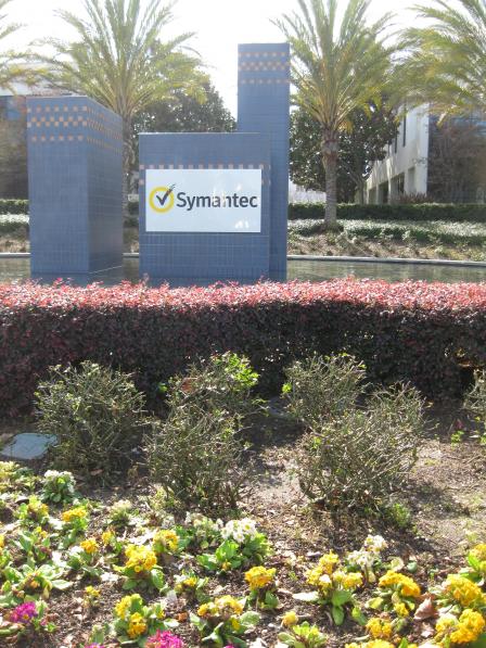 Raytheon Corp.The Raytheon Corp. Superfund site is located in Mountain View, California. Raytheon previously manufactured semiconductors on the 30-acre property. The site is part of the Middlefield-Ellis-Whisman (MEW) Study Area. The MEW Study Area also includes the Fairchild Semiconductor Corp. (Mountain View Plant) Superfund site, the Intel Corp. (Mountain View Plant) Superfund site, and the portions of the former Naval Air Station (NAS) Moffett Field Superfund site where MEW and Navy groundwater contamination have mixed. In the 1960s and 1970s, several industrial companies involved in semiconductor, electronics, and other manufacturing and research activities contaminated area soil and groundwater. Operations at the former NAS Moffett Field also resulted in groundwater contamination. Between 1986 and 1991, EPA placed these four sites on the Superfund program’s National Priorities List (NPL). In 1989, EPA began cleanup to address soil and groundwater contamination across the MEW Study Area. Soil cleanup actions are complete. Groundwater treatment and monitoring continue. Efforts to address vapor intrusion into buildings from contamination beneath the ground are also underway. The headquarters for Symantec is now located at the Raytheon property. The business provides information security, storage and systems management solutions. Several other software and telecommunications businesses also operate on site.
For more information:
Riverbank Army Ammunition Plant
The 173-acre Riverbank Army Ammunition Plant (RBAAP) facility is located in Riverbank, California and is comprised of large production buildings with numerous support buildings. Aluminum Company of America (ALCOA) originally constructed the RBAAP as an aluminum reduction plant supplying the military. In 1951, the plant was converted to a government-owned, contractor-operated installation to produce steel cartridge cases until 2009. Decades of industrial activities resulted in contamination of site ground water, sediment and soil. Contaminants include heavy metals, chromium and cyanide. Investigations also discovered the contamination of on-site treatment pond sediment. In 1989, the U.S. Army supplied nearby residents with bottled water after the discovery of chromium in off-site domestic water wells. The U.S. Army supplied an alternative water supply to residents until the public water system was extended west of the RBAAP. Currently residents do not use the ground water for drinking. EPA placed the site on the National Priorities List (NPL) in 1990. In 1993, the U.S. Army removed contaminated sediments from its industrial waste treatment ponds and disposed of the sediments off-site. The Army’s 1994 cleanup plan involved pumping and treating ground water and the stabilization, capping and monitoring of the on-site landfill. Placed on the Base Realignment and Closure (BRAC) list in 2005, the site is undergoing closure and transfer to the City of Riverbank Local Redevelopment Authority. The general land use designation of the RBAAP is presently industrial. Private businesses currently lease various buildings at the facility for a variety of light to heavy industrial activities. Based on the available infrastructure and other property improvements, it appears likely that the future use of existing buildings will be light to heavy industrial and offices.
For more information:
Rockets, Fireworks, and Flares
The Rockets, Fireworks, and Flares Superfund site, formerly known as the B.F. Goodrich Superfund site, consists of a 160-acre industrial area in Rialto, California and a five-mile long area of groundwater contamination. In 1942, the U.S. Army used a portion of the site to store ammunition and weapons. After World War II, the land was sold and used by defense contractors and fireworks manufacturers. The firms included West Coast Loading Corporation, B.F. Goodrich Corporation, Pyrotronics, Pyro Spectaculars, and American Promotional Events. Operators from these companies handled perchlorate salts and other hazardous chemicals and disposed of chemical wastes on site. Eventually the chemicals seeped into the ground and contaminated the groundwater supply. Many residents receive drinking water from the water supply underneath Rialto. The California Regional Water Quality Control Board led initial efforts to respond to the contamination. EPA added the site to the Superfund program’s National Priorities List (NPL) in September 2009. The Goodrich Corporation, Emhart Industries (a corporate successor to West Coast Loading Corporation), Pyro Spectaculars, American Promotional Events, and others have entered into agreements with EPA to pay for cleanup work at the site. While cleanup work continues, Pyro Spectaculars, Inc. and American Promotional Events still operate at the site.
For more information:
San Fernando Valley (Area 1)
The San Fernando Valley (Area 1) Superfund site (SFV Area 1) is one of four Superfund sites located in the California’s San Fernando Valley. EPA added these sites to the Superfund program’s National Priorities List (NPL) in 1986. The San Fernando Valley groundwater basin provides drinking water to residents of the Cities of Los Angeles, Burbank and Glendale, and the La Crescenta Water District. Contamination of area groundwater resulted from a range of industrial operations. The site covers about 20 square miles, and includes the areas of North Hollywood, Sunland and Burbank. This heavily developed urban area is a mix of residential, commercial and industrial land uses. EPA oversees the cleanup of groundwater contaminated with volatile organic compounds and metals. Two groundwater pump-and-treat systems have operated in the North Hollywood and Burbank areas since 1989 and 1996, respectively.
For more information:
San Fernando Valley (Area 2)
The San Fernando Valley (Area 2) Superfund site (SFV Area 2) is one of four Superfund sites located in California’s San Fernando Valley. EPA added the site to the Superfund program’s National Priorities List (NPL) in 1986. The San Fernando Valley groundwater basin provides drinking water to residents within the Cities of Los Angeles, Burbank and Glendale, and the La Crescenta Water District. Contamination resulted from a range of industrial operations. The site consists of contaminated groundwater covering about 6,680 acres near the Crystal Springs Well Field in the Cities of Los Angeles and Glendale. The site supports industrial, residential, recreational and commercial land uses. A groundwater pump-and-treat system to address volatile organic compound (VOC) contamination began operating under EPA oversight in 2000. Remedial designs for enhancements to the VOC remedy to improve capture are in progress. An evaluation of the potential for vapor intrusion across Area 2, which will be performed under EPA oversight, is in the planning phase. In 2004, EPA began investigating chromium contamination at the site. EPA created the Glendale Chromium Operable Unit in 2007 to characterize chromium contamination in groundwater and to evaluate potential remedial alternatives. EPA is in the process of finalizing the Remedial Investigation.
For more information:
San Fernando Valley (Area 3)
The San Fernando Valley (Area 3) Superfund site (SFV Area 3) is a delisted Superfund site. SFV Area 3 is one of four San Fernando Valley Superfund sites that EPA added to the Superfund program’s National Priorities List (NPL) in 1986. SFV Area 3 is located in a basin that is hydrologically separate from the other three San Fernando Valley sites. Located in the Verdugo basin east of the Verdugo Mountains, the site covers an area of about 4,400 acres. Land use in the Verdugo Basin is primarily residential along the floor of the valley and undeveloped (open space) in surrounding mountains. A strip of commercial development is present along Foothill Boulevard, and a Y-shaped commercial sector is present in the southern portion of the basin. The basin also contains four scattered agricultural areas. The Verdugo basin supplies water to an unincorporated area of Los Angeles County, known locally as La Crescenta. La Crescenta Water District is responsible for supplying water to residents of the area. After reviewing results of groundwater monitoring conducted from the 1980s until 2002, EPA, with support from the State, determined that Superfund cleanup actions at the site were not necessary. EPA deleted the site from the NPL in 2004.
For more information:
San Fernando Valley (Area 4)
The San Fernando Valley (Area 4) Superfund site (SFV Area 4) is one of four Superfund sites located in California’s San Fernando Valley. EPA added these sites to the Superfund program’s National Priorities List (NPL) in 1986. The San Fernando Valley groundwater basin provides drinking water to residents of the cities of Los Angeles, Burbank and Glendale, and the La Crescenta Water District. Contamination to area groundwater resulted from a range of industrial operations. SFV Area 4 covers about 5,860 acres near the Pollock Well Field in Los Angeles. SFV Area 4 is within a heavily developed urban area that includes a mix of residential, commercial and industrial land uses. EPA completed an interim investigation of the Pollock Well Field in April 1994. Because the Los Angeles Department of Water and Power designed and built a volatile organic compound (VOC) treatment facility, EPA determined further cleanup was not immediately necessary. The Pollock Treatment Plant became operational in 1999. EPA plans to evaluate the effectiveness of the Pollock Well Field project as part of its ongoing basin-wide studies, and determine the need for additional cleanup actions at the site. While the site awaits further investigation on the nature and extent of contamination in this area, the Pollock wellhead treatment operation continues to reduce the potential of exposure to contaminated drinking water and protect nearby residents.
For more information:
San Gabriel Valley (Area 1)
The San Gabriel Valley (Area 1) Superfund site is one of four San Gabriel Valley Superfund sites in Southern California. The San Gabriel Valley Superfund sites include multiple areas of contaminated groundwater in the 170-square-mile San Gabriel Valley. In 1984, EPA listed the four main areas of groundwater contamination in the valley on the Superfund program’s National Priorities List (NPL). The Area 1 site includes about 10 square miles of groundwater contamination underlying portions of the cities of El Monte, Rosemead and Temple City; about 8 square miles of groundwater contamination underlying portions of the cities of South El Monte, El Monte and Rosemead; and about 4 square miles of groundwater contamination in the southernmost part of San Gabriel Valley. In addition to industrial, commercial, residential and open space land uses, portions of the site support recreational uses and flood control. EPA has overseen treatment of groundwater in Area 1 since the early 2000s. EPA continues to oversee the construction of additional groundwater treatment systems. Investigations and studies are also underway, including an effort to identify the sources of contamination. To date, investigators have found soil contamination at nearly 400 individual facilities. Water utilities in the area provide clean water that meets all state and federal drinking water standards.
For more information:
San Gabriel Valley (Area 2)
The San Gabriel Valley (Area 2) Superfund site is one of four San Gabriel Valley Superfund sites in Southern California. The San Gabriel Valley Superfund sites include multiple areas of contaminated groundwater in the 170-square-mile San Gabriel Valley. In 1984, EPA listed the four main areas of groundwater contamination in the valley on the Superfund program’s National Priorities List (NPL). The Area 2 site (also known as the Baldwin Park Operable Unit) includes groundwater contamination underlying portions of the cities of Azusa, Irwindale, Baldwin Park, West Covina, La Puente and Industry. The site covers about 10 square miles. Land use at the site is largely suburban, with a mix of residential, commercial and industrial development. The site’s cleanup includes the operation of four large groundwater pump-and-treat systems. Groundwater treatment began in 2002. Water utilities in the area provide clean water that meets all state and federal drinking water standards.
For more information:
San Gabriel Valley (Area 3)
The San Gabriel Valley (Area 3) Superfund site is one of four San Gabriel Valley Superfund sites in Southern California. The San Gabriel Valley Superfund sites include multiple areas of contaminated groundwater in the 170-square-mile San Gabriel Valley. In 1984, EPA listed the four main areas of groundwater contamination in the valley on the Superfund program’s National Priorities List (NPL). The Area 3 site covers 19 square miles containing regions of groundwater contamination in Los Angeles County. Cities within Area 3 include Alhambra, Rosemead, San Gabriel, San Marino, South Pasadena and Temple City. Land use within the site is mainly commercial and residential, with limited areas of light industry and open space. EPA continues investigating the site and is preparing a feasibility study for the Northeast and Southwest Operable Units to address the source contamination. Water utilities in the area provide clean water that meets all state and federal drinking water standards.
For more information:
San Gabriel Valley (Area 4)
The San Gabriel Valley (Area 4) Superfund site is one of four San Gabriel Valley Superfund sites in Southern California. The San Gabriel Valley Superfund sites include multiple areas of contaminated groundwater in the 170-square-mile San Gabriel Valley. In 1984, EPA listed the four main areas of groundwater contamination in the valley on the Superfund program’s National Priorities List (NPL). The sites include industrial, commercial and residential land uses, as well as undeveloped areas. The Area 4 site (also known as the Puente Valley Operable Unit), is a 23-square-mile sub-basin of the Main San Gabriel Basin. The site is located primarily within the City of Industry, in the City of La Puente and in unincorporated areas of Los Angeles County. The majority of land in the Puente Valley supports commercial and industrial purposes; a small portion supports residential uses. EPA has planned three groundwater pump-and-treat systems to protect the water supply in the “mouth of the valley” portion of the Puente Valley and prevent further contaminant movement. Construction of the systems began in 2006. The completion of these systems has been delayed to allow for additional study of alternative end use options of treated groundwater. EPA anticipates the cleanup system will be in place in 2018. Water utilities in the area provide clean water that meets all state and federal drinking water standards.
For more information:
Selma Treating Co.
The Selma Treating Co. Superfund site is located in Selma, California. The 18-acre site includes a 4-acre facility and 14 acres surrounding the facility. Since 1936, wood preservation operations occurred on site. Operators dipped wood into pentachlorophenol (PCP) and oil for preservation. Excess PCP and oil dripped onto the ground. Although the wood treatment process changed in 1965, operators continuously disposed of wood treatment products and waste fluids in various areas surrounding the facility. One of these areas included a vineyard located downgradient of the site. EPA added the site to the Superfund program’s National Priorities List (NPL) in 1983. Cleanup began in 1988 and included excavation and stabilization of contaminated soils and materials. Workers then contained the soil and materials under a protective cap. EPA also closed off groundwater wells on site and implemented restrictions on groundwater use. The owner of the 4-acre facility currently uses the site for storage, maintaining large trucks, metal lighting poles and other property in storage in the open area. EPA’s cleanup plan also included removal of contaminants from the nearby affected vineyard, which supported the area’s agricultural use and today the vineyard remains operational. EPA is currently completing groundwater monitoring and will construct additional monitoring wells in 2016 to better define the downgradient extent of the chromium groundwater plume. Additionally, EPA continues groundwater treatment activities at the site, including the use of bioremediation to break down contaminants into non-threatening substances.
For more information:
Sola Optical USA, Inc.
 Sola Optical USA, Inc.The 35-acre Sola Optical USA, Inc. (Sola Optical) Superfund site is located in Petaluma, California, about 30 miles north of San Francisco. Sola Optical manufactured ophthalmic lenses at the site from 1978 through 2001. The facility included one manufacturing building and an adjoining administration office building. In 1982, the State identified acetone in an on-site well. Later, Sola Optical reported contaminated soil next to six underground solvent storage tanks at the facility. In 1985, Sola Optical removed the underground storage tanks and surrounding soil and confirmed the existence of contamination in shallow groundwater underneath the site. EPA added the site to the Superfund program’s National Priorities List (NPL) in 1990. Sola Optical treated groundwater at the site from 1988 to 1997. In 2007, EPA agreed to allow the groundwater to recover naturally. In 2012, EPA confirmed that the groundwater had achieved the cleanup standards. EPA removed the site from the NPL in 2013. In 2000, RNM Cader, LLC, purchased about 11 previously-undeveloped acres in the southwest portion of the site for development. Between 2005 and 2010, RNM Cader constructed an asphalt parking lot and four building pads. The owner of the remaining 24 acres of the Sola Optical property sold the property and buildings to Kland, LLC in 2002. Two commercial tenants currently occupy the buildings on the site facility parcel. Petaluma Poultry’s administrative office occupies one building, conducting sales and distribution of poultry. Reynolds Packaging conducts storage and distribution of food packaging materials from the original manufacturing building.
For more information:
Solvent Service, Inc.
The 3.5-acre Solvent Service, Inc., Superfund site is located in San Jose, California. Solvent Service, Inc., previously recycled waste solvents from nearby industries on site. The waste solvents contaminated soil and groundwater on and off the site. The site is within 1 mile of wells that supply municipal water for 132,000 people. EPA proposed the site to the Superfund program’s National Priorities List (NPL) in 1988. A Resource Conservation and Recovery Act (RCRA) permit was issued in 1989, and the site was dropped from the proposed NPL. Solvent Service began treating contaminated soil in early 1990 and groundwater treatment is ongoing. Currently, Clean Harbors of San Jose, LLC operates a hazardous waste treatment, storage and disposal facility on site.
For more information:
South Bay Asbestos Area
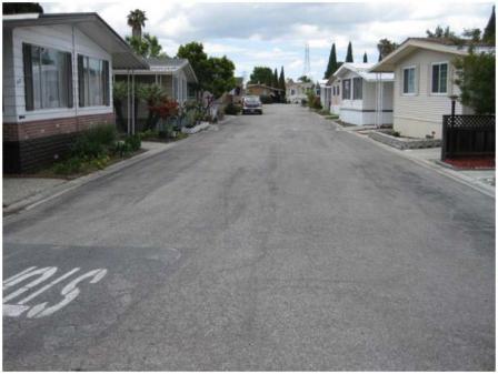 South Bay Asbestos AreaThe 550-acre South Bay Asbestos Area Superfund site is located in San Jose, California and includes the neighborhood of Alviso. Three landfills were open from 1953 to 1982 and they may have received asbestos waste from an asbestos cement pipe manufacturing plant. Investigations also found asbestos in the Guadalupe River ring levee surrounding Alviso. EPA placed the site on the Superfund program’s National Priorities List (NPL) in 1986. Cleanup activities have included paving asbestos contaminated lots, removing asbestos debris and soils, covering the landfills, and putting land use restrictions in place. Cleanup also included removal of the Guadalupe River ring levee, the largest source of asbestos at the site. Restoration of wetlands under the levee followed the levee removal. Cleanup actions at the site are complete and long-term maintenance and regular inspections of the landfill covers are ongoing. Today, site reuse includes two thriving business parks. The 70-acre America Center has commercial office space and occupies the former Marshland Landfill area. Gold Street Tech Center is located on part of the former Santos Landfill. It provides commercial space and office space for a wide range of businesses. Specific land uses on site include commercial office space, hotel, wetlands, open space, recreational areas such as trails, volleyball court and a basketball court, and truck yards. Cleanup has made it possible for people to continue to live, work and play safely throughout Alviso.
For more information:
- Reuse and the Benefit to Community: South Bay Asbestos Area Case Study (2015) (PDF)(15 pp, 766 K, About PDF)
- Redevelopment of the South Bay Asbestos Area Superfund Site (PDF) (1 pg, 133 K)
- Superfund Site Profile Page
Spectra-Physics, Inc.
The 11.5-acre Spectra-Physics, Inc. Superfund site is located in Mountain View, California, northwest of San Jose. The Teledyne Semiconductor Superfund site borders the Spectra-Physics, Inc. site. Contaminated groundwater from both sites merged and the successors to Teledyne Semiconductor and Spectra-Physics, Inc. are jointly managing cleanup of the site. The Spectra-Physics, Inc. site had been the location of a manufacturer of electronic equipment and gas lasers since 1961. Past operations at the Spectra-Physics, Inc. site resulted in soil and groundwater contamination. EPA added the site to the National Priorities List (NPL) in 1991. EPA’s approved cleanup plan for the site called for removing vapors from soil and pumping and treating groundwater. The potentially responsible parties completed the soil cleanup in 1995. Groundwater treatment continues and indoor air vapor intrusion investigations and mitigation work is ongoing. The original on-property Spectra-Physics, Inc. buildings are no longer used for electronic equipment manufacturing. They have been redeveloped for other commercial use.
For more information:
Synertek, Inc. (Building 1)
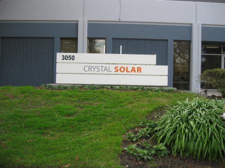 Synertek, Inc. (Building 1)The 1.5-acre Synertek, Inc. (Building 1) Superfund site is located in Santa Clara, California, in the area known as Silicon Valley. The property consists of a low rise building and landscaping and parking areas. Synertek used the on-property building constructed in 1974 for performing quality control of chemicals and electrical testing of semiconductors beginning in 1978. Honeywell Inc. acquired Synertek as a wholly owned subsidiary in 1979. Synertek manufactured semiconductor products in the building from March 1978 to February 1985. Historical operations at the site included the use of a 200-gallon solvent tank and three neutralization tanks. After the removal of these tanks and surrounding soil in 1985, investigators discovered contamination of on-site and off-site ground water. Honeywell installed three on-site and two off-site ground water extraction wells with an air stripping tower to treat the extracted ground water. In 1989, EPA added the site to the National Priorities List (NPL) because of the potential threat to the Santa Clara Valley ground water basin. Ground water extraction continued until 2001. Since then, EPA has allowed the ground water to recover naturally. Private property owners currently lease the building to Crystal Solar. Crystal Solar uses the southern two-thirds of the building (about 16,000 square feet) as office space and for research and development of solar panels. In addition, Crystal Solar has expanded to the northwest portion of the building and leases the remainder of the building to private tenant.
For more information:
Teledyne Semiconductor
The one-acre Teledyne Semiconductor Superfund site housed a semiconductor manufacturing facility since 1962. The site is located next to the Spectra-Physics, Inc. Superfund site in a densely populated area of Mountain View, California, northwest of San Jose. Past operations at the Teledyne Semiconductor site resulted in groundwater contamination. EPA added the site to the National Priorities List (NPL) in 1987. The potentially responsible parties for the Spectra-Physics Lasers, Inc. and Teledyne Semiconductor sites began cleanup actions in the mid-1980s and early 1990s. Groundwater treatment continues and indoor air vapor intrusion investigations and mitigation work is ongoing. The on-property Teledyne Semiconductor site building remains in use for light industrial and commercial activities.
For more information:
United Heckathorn Co.
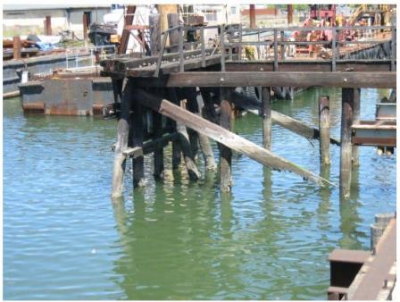 United Heckathorn Co.The United Heckathorn Superfund site is located on Richmond Harbor in Contra Costa County, California. The industrial area is dominated by active petroleum and shipping terminals. The site includes 5 acres of land (the upland area) and about 15 acres of marine sediments in the Lauritzen Channel and Parr Canal of Richmond Harbor. From 1947 through 1966, several companies used the site to formulate, package and ship pesticides. During United Heckathorn's operation at the site, the Bay Area Regional Water Quality Control Board observed bulk storage of pesticides and solvents, leaking solvent pump lines, spills, and waste discharges in 1960. In 1980, the state found contamination in soil samples and the area was designated a State Superfund site in March 1982. EPA placed the site on the Superfund program’s National Priorities List (NPL) in 1990. Cleanup at the site took place from 1990 through 1999. Activities included excavating contaminated areas, dredging the Lauritzen Channel and Parr Canal, and capping 5 acres of the site. Additional monitoring found that high levels of pesticides remain in Lauritzen Channel. EPA is currently conducting a Focused Feasibility Study to identify and evaluate options for further remedial action. The Levin-Richmond Terminal Corporation (LRTC) purchased the upland area in 1981 and currently operates a marine shipping terminal at the former United Heckathorn facility. LRTC mainly uses the upland area for cargo stockpiling and railroad operations. LRTC and Manson Construction, a dredging contractor located along the west shoreline of the Lauritzen Channel, continue to use Lauritzen Channel as a deep-water channel. IMTT recently purchased property adjacent to the northwest corner of Lauritzen Channel. Parr Canal is currently unused.
For more information:
Waste Disposal, Inc.
The 38-acre Waste Disposal, Inc. Superfund site is located in Santa Fe Springs, California. Between the early 1940s and the mid-1960s, previous businesses used an on-site reservoir to dispose of waste. In 1984 and 1985, testing by the City of Santa Fe Springs determined that waste disposal activities contaminated soil and groundwater with hazardous chemicals. EPA added the site to the Superfund program’s National Priorities List in 1987. Cleanup activities involved capping, removing and treating gases, as well as monitoring and restricting groundwater use. Grass to protect the cap and improve stormwater drainage now covers most of the central reservoir area. EPA worked with state agencies, potentially responsible parties (PRPs), business owners and land owners to allow businesses to continue operating on site during cleanup. They also collaborated to develop a cleanup plan that could allow for commercial or industrial development opportunities in the future. Site PRPs repaved business driveways, parking areas and walkways. They also worked with the nearby high school to address public safety concerns. They built a large backstop behind the school’s baseball and soccer fields to prevent stray balls from entering the site, eliminating the need for students to enter the site to retrieve them. Currently, over 40 commercial and light industrial businesses are located on site. These businesses employ over 160 people. In 2013, these businesses contributed about $9.5 million in local employment income and business sales reached nearly $23 million.
For more information:
- Reuse and the Benefit to Community: Waste Disposal, Inc. Case Study (2014) (PDF) (13 pp, 752 K, About PDF)
- Superfund Site Profile Page
Watkins-Johnson Co. (Stewart Division Plant)
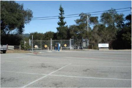 Watkins-Johnson Co. (Stewart Division Plant)The 43.7-acre Watkins-Johnson Co. (Stewart Division) Superfund site is located in Santa Cruz County, about five miles north of the city of Santa Cruz. From 1963 until 1999, Watkins-Johnson operated a semiconductor manufacturing facility at the site. Operations at the Watkins-Johnson facility contaminated the Santa Margarita aquifer, a major source of groundwater in the site area. EPA added the site to the National Priorities List (NPL) in 1990. Manufacturing activities continued under several property owners until 2011. Soil cleanup is complete. EPA requested the responsible party conduct a vapor intrusion investigation. Groundwater monitoring continues. Today, a few commercial/industrial tenants use site buildings. Past historic activities included research, furnace and electronic parts manufacturing, degreasing, metal plating, glass cleaning and etching, and photo lab activities.
For more information:
Western Pacific Railroad Co.
The 90-acre Western Pacific Railroad Co. (WPRR) Superfund site is located outside of Oroville, California. The site began operating as a rail yard in the 1880s. Activities at the site included welding, painting, machining and fueling locomotives. These activities occurred in a 10-acre area known as the Fueling Area. In 1970, WPRR stopped activities and leased the Fueling Area to an independent railcar company until 1991. WPRR, and the next owner, Union Pacific Railroad (UPRR) Co., continued to use some of the site until 1991, when UPRR dismantled or demolished the remaining structures. EPA added the site to the Superfund program’s National Priorities List (NPL) in 1990 because of contaminated on-site groundwater. UPRR installed two groundwater treatment systems in 1994 and 1997 and removed contaminated soil in 1998. After determining that UPRR had successfully cleaned up the site, EPA deleted the site from the NPL in 2001. Currently, the Fueling Area is inactive, but the rest of the site has a maintenance shop, a small classification yard and an active rail line. UPRR leases a public drinking water well, which is located on the site just west of the Fueling Area rail line, to California Water Service.
For more information:
Westinghouse Electric Corp. (Sunnyvale Plant)
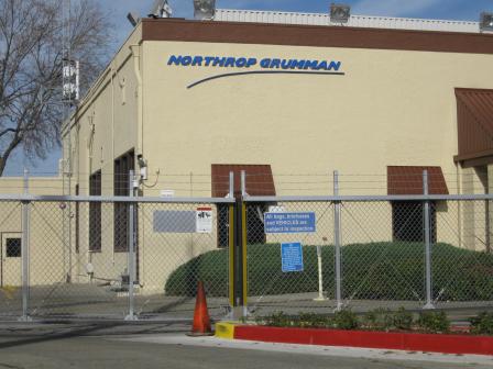 Westinghouse Electric Corp. (Sunnyvale Plant)The 75-acre Westinghouse Electric Corporation (Sunnyvale Plant) Superfund site is located in Sunnyvale, California. The Westinghouse Electric Corporation used the facility to manufacture electrical transformers. During this time, groundwater contamination resulted from a leaking storage tank and spills on site. Site investigations also found fuel and other contamination in area groundwater and soil. EPA added the site to the Superfund program’s National Priorities List (NPL) in 1986. Cleanup activities included the removal or paving of contaminated areas and the removal and treatment of contaminated groundwater. In 1996, Northrop Grumman purchased the site. The company is a U.S. defense contractor that employs nearly 1,000 people at the facility.
For more information: