About St. Marys River AOC
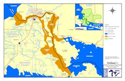 St. Marys River AOC Boundary MapThe St. Marys River is a globally unique river that forms the binational connecting channel between Lake Superior and Lake Huron, two of the largest freshwater systems in the world, with shared jurisdiction between the Canadian Province of Ontario and the State of Michigan. Both communities have a strong tourism-based economy that is centered on sport fishing and other recreational activities on the St. Marys River. The Area of Concern extends from the head of the river at Whitefish Bay, downstream through the St. Joseph Channel to Humburg Point on the Ontario side, and to the straits of Detour on the Michigan side.
Sources of Pollution
As a result of industry and municipal discharges, sediments have become contaminated with toxics such as arsenic, cadmium, chromium, copper, cyanide and lead. Other contaminants of concern include oils and greases, suspended solids, metals, phenols, ammonia, bacteria, and PAHs. Sources contributing to the 10 beneficial use impairments include:
- Algoma Steel
- Two Ontario water pollution control plants
- Combined sewer overflows,
- St. Marys Paper
- Various nonpoint sources
Beneficial Use Impairments
- Degradation of aesthetics – Removed 2014
- Bird or animal deformities or reproduction problems – Removed 2014
- Restrictions on fish and wildlife consumption
- Eutrophication or undesirable algae
- Degradation of fish and wildlife populations
- Beach closings
- Degradation of benthos
- Restriction on dredging activities
- Loss of fish and wildlife habitat
- Fish tumors or other deformities