About St. Lawrence River AOC
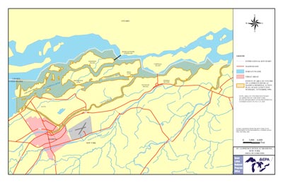 St. Lawrence River AOC Boundary Map
The St. Lawrence River at Massena begins above the power dam facilities and seaway locks at the Massena Village drinking water intake. It follows the river downstream for about fifteen miles to the international border. In 1987 the St. Lawrence River was designated an AOC as part of the Great Lakes Water Quality Agreement of 1987.
The area was considered highly degraded because of:
- historical industrial discharges
- municipal treatment facilities
- atmospheric deposition
- atmospheric depositionThe process by which airborne pollutants settle onto land or water. "Wet deposition" refers to pollutants that fall to the earth while attached to raindrops or snowflakes. "Dry deposition" refers to pollutants that fall to the earth without precipinon-point source discharges
- atmospheric depositionThe process by which airborne pollutants settle onto land or water. "Wet deposition" refers to pollutants that fall to the earth while attached to raindrops or snowflakes. "Dry deposition" refers to pollutants that fall to the earth without ppower dam and seaway construction
- high levels of PCBs
- Mercury, DDE, Mirex, nutrients and metals are also the cause for much of the pollution
non-point sourceSource of pollution in which wastes are not released at one specific, identifiable point but from a number of points that are spread out and difficult to identifThe AOC includes portions of the Grasse, Raquette and St. Regis Rivers in New York State. The United States, Canada and the St. Regis Mohawk Tribe at Akwesasne share authority for the AOC.
Beneficial Use Impairments
- Restrictions on fish and wildlife consumption
- Loss of fish and wildlife habitat
- Degradation of fish and wildlife populations (likely impaired)
- Fish tumors or other deformities (likely impaired)
- Bird or animal deformities or reproduction problems (likely impaired)
- Degradation of benthos (likely impaired)
- Degradation of phytoplankton and zooplankton populations (likely impaired)