Conducting Source Water Assessments
On this page:
- Source water assessment steps
- Public availability of the source water assessment results
- Using assessments for protection
Source water assessment steps
Source water assessments (SWAs) provide information about sources of drinking water used by public water systems. SWAs are studies or reports developed by states to help local governments, water utilities, and others protect sources of drinking water.
SWA programs differ by state. Each program is adapted to a state’s water resources and drinking water needs.
SWAs include these steps:
- Delineate (identify) the source water protection area.
- Conduct an inventory of potential sources of contamination.
- Determine the susceptibility (vulnerability) of the water supply to contamination.
Assessments results are made available to:
- Public water systems
- Local governments
- Non-governmental organizations
- Other stakeholders
The Safe Drinking Water Act requires states to develop EPA-approved programs to carry out assessments for all public water systems in the state.
Step 1: Delineate the source water assessment area.
Ground water wells and surface water intakes supply drinking water to public water systems. States must delineate (map) the land area that could contribute pollutants to the water supply for each public water system.
States identify potential sources of contamination in the delineated area during Step 2 of the assessment process.
For ground water wells: States use information about the flow of underground water to delineate source water assessment boundaries. This results in a map that shows land areas where spilled or discharged pollutants could filter through the soil and get into the ground water. Some states use a simpler mapping approach, drawing a circle of a certain radius around each well.
For surface water intakes: States identify the land area in the watershed upstream of a water system’s intake. A watershed boundary is drawn on a topographic map. The boundary includes the land areas where rain or melted snow flows through the ground and enters the water source upstream of the intake.
Some states divide the watershed area into segments. These may include areas closest to the intake, where most types of contamination sources can affect the water supply, as well as other, more distant areas. The entire watershed up to the state's boundaries might be delineated. The inventory of potential pollution sources might be more detailed in the segments closer to the intake.
After the state has completed its assessment for a water system, the community may decide to undertake protection efforts for targeted sources of contamination. An initial step could be to expand on the state's delineation process, particularly for small ground water systems where states might not have had resources to conduct a detailed delineation. Additional scientific methods can be used to more accurately delineate the area that contributes ground water to the well.
Communities can seek assistance for more detailed delineations from:
- Local environmental consulting firms
- Federal agencies
- Natural Resources Conservation Service
- United States Geological Survey
- States' Cooperative Extension Service
- Environmental sciences, geology or engineering departments of local colleges
Step 2: Conduct an inventory of potential sources of contamination
Community groups and public water systems may be involved in this assessment step -- identifying potential sources of pollutants that could contaminate the water supply. This inventory can provide a list and map of facilities and activities within the delineated area that might release contaminants into the source water.
Some examples of potential pollutant sources are: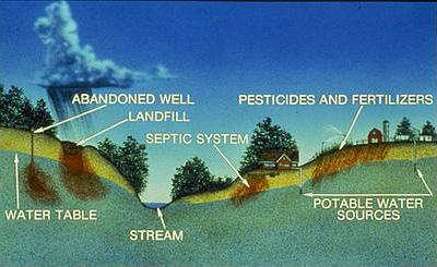 Contaminants reach ground water through spetic systems, landfills, abandoned wells, and over application of pesticides and fertilizers.
- Landfills
- Underground or above ground storage tanks
- Residential or commercial septic systems
- Stormwater runoff from streets and lawns
- Farms that apply pesticides and fertilizers
Some states asked communities or public water systems to review the inventory to obtain detailed information. Others used computer databases to focus on land uses and activities currently mapped or regulated. Examples of database inventories might include:
- Small livestock areas
- Auto salvage yards
- Industrial and sewage treatment plants that discharge wastewater
- Hazardous waste sites
- Mining operations
 Potential sources of contamination will vary depending upon land use in the watershed.
 - Certain land use categories (industrial, agricultural, urban)
- Facilities that have environmental permits
Community groups such as watershed organizations, local environmental committees, or scout troops can enhance the state's assessment by conducting site-specific inventories of potential pollutant sources that might not be on state databases or maps. Local inventories might provide information on:
- Abandoned dump sites
- Businesses with septic tanks or floor drains (such as dry cleaners or car repair shops)
- Pesticide mixing and storage areas
- Golf courses
- Other land uses that might release pollutants to ground water or surface water
Community groups can coordinate their local inventory with the state's assessment process or can enhance a completed assessment with a more detailed inventory.
Step 3: Determine the susceptibility of the water supply to contamination
This critical step provides information that local decision makers can use to prioritize their approaches for protecting the drinking water supply. The state combines the inventory results with other relevant information to decide how likely a water supply is to be contaminated by identified potential sources of contamination. States may use information such as:
- Data from local community groups about contaminant sources
- Characteristics of local water resources or geology
- Local and regional environmental management practices
| Contaminant/Activity | Level of Concern | Risk Reducing Fators | Susceptibility |
|---|---|---|---|
| leaking underground storage tanks | high | remove or repair tanks | high |
| concentrated animal feeding operations | moderate | new and, or upgraded facility and new equipment | low |
| road salt storage shed | moderate | diked facility with berms | moderate |
Some states prioritize susceptibility based on the potential sources of contamination or specific chemicals that could pollute the water. Other states assign susceptibility rankings of high, medium, or low to water sources.
Public availability of the source water assessment results
After a state completes the assessment of a water system, it summarizes the information for the public. Summaries help community governments, water utitlities, and planning agencies to:
- Understand the potential threats to their water supplies
- Identify priority needs for protecting the water from contamination
States make the summaries of assessments available in different ways, such as:
- Convene public workshops
- Make copies available in public libraries
- Make copies available from local government offices or water suppliers
- Post information on the assessment to the Internet
Source water assessments and consumer confidence reports (CCRs)
Often referred to as water quality reports, CCRs inform people:
- Where their drinking water comes from
- What's in it
- How to help protect it
The CCRs have information on the availability of the assessment and a brief summary describing the system’s susceptibility to contamination. Please visit EPA's CCR website for more information.
Using the assessments for protection
Communities can use the information gathered through the state’s assessment process. Community groups and local officials working with local, regional and state government agencies can plan how to:
- Manage identified potential contamination sources
- Prevent new contamination in the source water assessment area
Communities use many different source water protection methods to prevent contamination of their drinking water supplies. One option is to pass regulations, such as prohibitions or restrictions on land uses that might release contaminants into source waters.
Communities might also hold local events and distribute information to educate citizens and businesses and encourage them to:
- Recycle used oil
- Limit their use of pesticides
- Participate in watershed cleanup activities
- Conduct other protection activities
Communities may also choose to purchase land or create conservation areas to serve as a protection zone near the drinking water source. Communities should consider using a variety of prevention measures.