Basic Information about Surface Coal Mining in Appalachia
What is Surface Coal Mining?
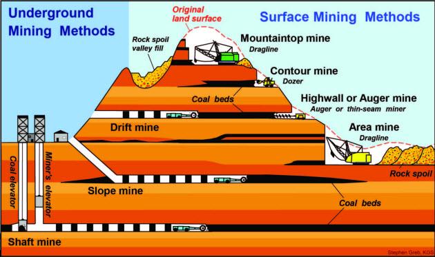
Surface coal mining in the steep terrain of the central Appalachian coalfields includes:
- mountaintop removal,
- contour,
- area,
- highwall, and
- auger mining.
Operations are concentrated in:
- eastern Kentucky,
- southern West Virginia,
- western Virginia,
- eastern Ohio, and
- scattered areas of eastern Tennessee.
Surface coal mining involves:
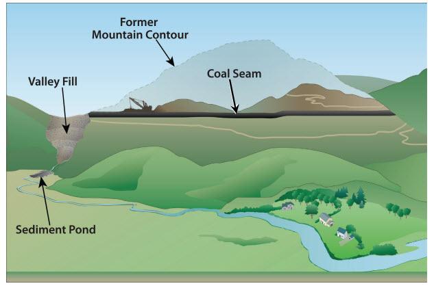
- removing parts or all of mountaintops to expose buried seams of coal, and
- disposing in adjacent valleys the excess:
- "overburden" (rock above the coal seam), and
- "interburden" (rock between coal seams).
Overburden and interburden are disposed of in adjacent valleys because the broken rock will not all fit back into the mining pit, and disposal alternatives are limited. The usual method of disposing of this excess soil and rock is to place it in engineered earthen and rock structures known as excess spoil disposal areas or colloquially known as head-of-hollow fills, hollow fills or valley fills. In some cases underground mining also produces enough spoil to require the construction of valley fills.
Mountaintop and area mining allows for almost complete recovery of coal seams, and reduces the number of workers required to a fraction of what conventional methods require but produces large volumes of excess spoil disposal needs.
There are five basic steps to these methods of mining:
- Layers of rock and dirt above and between the coal seams are removed.
- Coal seams are removed with excess soil and rock placed in an adjacent valley.
- Large scale earth moving equipment is used to excavate and remove coal from lower layers. The equipment used depends on the method and scale of the surface mining method being employed.
- Regrading begins as coal excavation continues.
- Once coal removal is complete, final regrading takes place and the area is revegetated. The operation is required to reclaim the mine to "AOC" or "approximate original contours" unless this requirement has been waived by the agency that has granted the Surface Mining Control and Reclamation Act of 1977 (SMCRA) permit for the operation.
Environmental Impacts
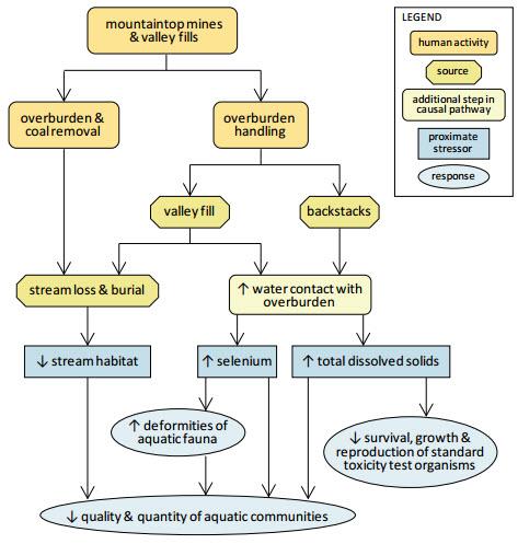
As noted in EPA's 2011 report The Effects of Mountaintop Mines and Valley Fills on Aquatic Ecosystems of the Central Appalachian Coalfields, mountaintop mines and valley fills lead directly to five principal alterations of stream ecosystems:
- springs and ephemeral, intermittent and perennial streams are permanently lost with the removal of the mountain and from burial under fill,
- concentrations of major chemical ions are persistently elevated downstream,
- degraded water quality reaches levels that are acutely lethal to organisms in standard aquatic toxicity tests,
- selenium concentrations are elevated, reaching concentrations that have caused toxic effects in fish and birds, and
- macroinvertebrate and fish communities are consistently degraded.
- loss of large tracts of forested areas;
- fragmentation of forests; and
- conversion of habitats (i.e. forest to grasslands) resulting in displacement or loss of species.
The scientific literature suggests that the headwater stream resources lost under valley fills may not be successfully reconstructed at the completion of reclamation of surface mines
A Summary Diagram of the Principal Observed and Expected Effects of Mountaintop Mining/Valley Fills on Aquatic Ecosystems

View a text description of this summary diagram
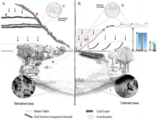
Small Stream Watershed Before and After Mountaintop Mining and Creation of a Valley Fill
(See a text explanation below the diagram.)

Notes: Monuments added for scale. Scales differ between upper and lower halves of diagram.
A. Before mining. The figure on the left side of the diagram illustrates the natural topography, geologic strata, and soil layers associated with small mountain streams in eastern coalfields.
- local aquifers (a),
- soil layer interflows (b), and
- minute stress fractures in geologic strata of the parent mountain (c).
Overland flow and subsurface flows (indicated by arrows) form seeps or springs (d) and channelized flows (e) that integrate features of the entire landscape, including riparian vegetation and diverse, in-stream biological communities.
B. After mining. On the right side, the same watershed is shown after the mountain rock layers have been removed, crushed, and deposited in the stream valley.
Flat surfaces of remaining rock layers are less permeable, producing higher surface runoff into a flood control channel (f) and valley fill (g) (height is approximate).
Infiltration though valley fills of water exposed to larger total surface area of porous unweathered rock (h) produces higher channelized flows and higher concentrations of dissolved ions and trace metals downstream, where biological communities shift towards tolerant taxa![]() taxaa grouping of organisms given a formal taxonomic name such as species, genus, family, etc. (i).
taxaa grouping of organisms given a formal taxonomic name such as species, genus, family, etc. (i).
Subsurface flowpaths in the intact geologic strata vary, depending on the types of rock in them, but water tables can ‘back up’ against the valley fill, elevating the water level in the fill, as shown at (j), increasing baseflows and exposure to valley fill materials. Photographs of macroinvertebrates by Greg Pond.


