About Saginaw River and Bay AOC
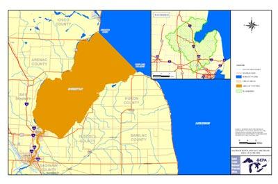 Saginaw River and Bay AOC Boundary Map The Saginaw Bay area, located in the east central portion of Michigan's Lower Peninsula, is a southwestern extension of Lake Huron. The boundaries of the Area of Concern includes the entire 22-mile length of the Saginaw River and all of Saginaw Bay out into its interface, with open Lake Huron at an imaginary line drawn between Au Sable Point and Point Aux Barques.
Sources of Pollution
- Industrial waste discharges
- Municipal, industrial and stormwater discharges
- Combined sewer overflows
- Agricultural and urban runoff
Contaminants in the AOC include dioxins, furans, PCBs, chloride, metals, acids, and excessive nutrients, such as nitrogen and phosphorus.
Beneficial Use Impairments
- Restrictions on fish and wildlife consumption
- Eutrophication or undesirable algae
- Tainting of fish and wildlife flavor – REMOVED 2008
- Restrictions on drinking water consumption, or taste and odor – REMOVED 2008
- Degradation of fish and wildlife populations
- Beach closings
- Degradation of aesthetics
- Bird or animal deformities or reproduction problems
- Degradation of benthos
- Degradation of phytoplankton and zooplankton populations
- Restriction on dredging activities
- Loss of fish and wildlife habitat – REMOVED 2014