About the Oswego River AOC
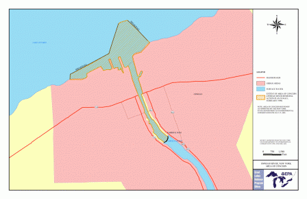 Printable boundary map and shapefile of the Oswego River AOCThe Oswego River/Harbor Area of Concern was located on the southeast shore of Lake Ontario and centered in the City of Oswego, New York. It was named an Area of Concern on the Great Lakes under the Great Lakes Water Quality Agreement of 1987.
The area was highly degraded because of hazardous waste sites, municipal sewage discharges, combined sewer overflows, and runoff from streets and agriculture. Some of those degradations were:
- Restriction on consumption of fish
- Eutrophication or harmful algal blooms
- Decline of fish populations
The AOC consisted of the harbor area and the lower segment of the Oswego River up to the Varick power dam. Contaminants found in AOC included:
- PCBs
- Dioxin
- Cyanide
- Grease
- Oil
- Mirex
- Excessive levels of phosphorus.
Beneficial Use Impairments
- Restrictions on fish and wildlife consumption - REMOVED 2006
- Degradation of fish and wildlife populations - REMOVED 2006
- Loss of fish and wildlife habitat - REMOVED 2006
- Eutrophication or undesirable algae - REMOVED 2006