Ocean Disposal Site Monitoring
EPA is responsible for the designation and management of all such designated ocean disposal sites (33 USC 1412). Management of ocean disposal sites involves regulating the times, quantity and characteristics of material dumped at the site; and establishing disposal controls, conditions and requirements to avoid or minimize potential impacts to the marine environment. All designated sites are required to have a site management and monitoring plan.
EPA Regional Offices conduct oceanographic surveys to monitor the impacts of regulated dumping at the ocean disposal sites. EPA Regional Offices often conduct site monitoring activities in coordination with the U.S. Army Corps of Engineers (USACE) because the vast majority of ocean sites are designated for the disposal of dredged material. Ocean disposal sites are monitored to ensure that dumping will not unreasonably degrade or endanger human health or the environment, to verify that unanticipated adverse effects are not occurring from past or continued use of the site, and to ensure that terms of the ocean dumping permit are met. Individual projects using the ocean disposal sites are also monitored for compliance with EPA site use conditions.
EPA Regional Ocean Dumping Coordinators and Chief Scientists plan and conduct oceanographic surveys at and around ocean disposal sites located off the U.S. Atlantic, Gulf and Pacific Coasts, and in the Caribbean, Hawaii and the Pacific Islands.
Monitoring Results
2013 National Ocean Dumping Site Monitoring Assessment Report (published in June 2016)
For additional information about EPA’s ocean survey activities at designated ocean disposal sites, please see the EPA Region-specific information on ocean dumping.
Types of Data Collected During Ocean Monitoring Surveys
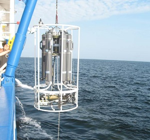
 A CTD (Conductivity, Temperature, Depth) instrument use to assess properties of sea water.Water Quality
EPA may use water quality data to detect any changes in water quality within an ocean disposal site or outside the boundaries as a result of ocean dumping. These data may be obtained by collecting water samples from various depths and analyzing the samples for chemical and other parameters, such as water clarity (turbidity), oxygen concentration or pH. Special probes may be used to collect data for some water quality parameters directly from ocean waters.
Sediment
EPA may use sediment data to determine if any changes in the quality or composition of sediment in an ocean disposal site or outside the boundaries of the site are due to ocean dumping. Sediment samples may be collected for chemical, grain size or other analyses such as organic carbon content. Special cameras may be lowered from suvey vessels to the seafloor to collect information about the composition of the sediment.
 Living Resources
EPA may use biological data to determine if changes to living resources within an ocean disposal site or outside the site’s boundaries are due to ocean dumping. Living resources may include fish as well as animals that live in the sediments such as clams and worms. To detect changes (impacts) to living resources, EPA may evaluate contaminant levels in the tissues of animals that live in and around the ocean disposal site or may assess changes in biological community, including the relative abundance of individual species.
Water Currents
EPA uses water current data to better understand the fate and transport of material that is dumped in the ocean (e.g., how material disperses or drifts after it is disposed in ocean waters).
Bottom Topography (Bathymetry)
In the same way that topographic maps represent three-dimensional features of overland terrain, bathymetric maps illustrate the land that lies underwater. EPA uses bathymetry (bottom topography) data to map the seafloor within an ocean disposal site and in the surrounding area and to help document where the material deposits after it is dumped in the ocean. Some material may deposit in low spots on the seafloor within an ocean disposal site. If the ocean dumped material piles up and mounds form, the water depth in the ocean disposal site may become too shallow for safe navigation. Ensuring that ocean dumping does not impact navigation is an important aspect of EPA’s management of ocean disposal sites. To direct and prioritize sampling activities, EPA may use bathymetric data to identify areas where ocean dumped material is present on the ocean floor.
Individual Project Compliance Monitoring
Compliance monitoring is intended to ensure that the conditions of the Marine Protection, Research and Sanctuaries Act (MPRSA) permit (or, in the case of federal projects, authorization) for ocean disposal are met and that the material is disposed at the correct location.
EPA, USACE, other federal agencies, and MPRSA permittees may conduct compliance monitoring activities. For example, MPRSA permittees may be required to provide detailed records of GPS tracking of the transit of the vessel(s) carrying the material to the ocean disposal site. Other measurements, such as how deep the vessel sits in the water (draft of the vessel) transporting the material to the ocean disposal site, may be required to document whether the material has leaked or spilled from the vessel to the site and to confirm that the material is disposed in the site in accordance with site use and permit conditions.
The instrumentation for compliance monitoring typically is comprised of a proprietary bundle of software and off-the-shelf hardware components (GPS receiver, draft sensors, data logger and data transmitter).
