Combined Sewer Overflows in the Great Lakes Basin
-
CSO Overview -
Policy, Reports,
and Training -
Frequent
Questions -
CSOs in the
Great Lakes Basin - Public Notification
Requirements for
the Great Lakes
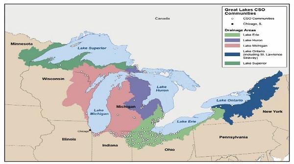
There are 190 NPDES permits which authorize discharges from CSOs to the Great Lakes Basin. These 190 permits have been issued to 182 communities. Select the tabs below for the list of CSO communities in the Great Lakes Basin in each state.
Proposed Public Notification Requirements for the Great Lakes
Public Notification Requirements for Combined Sewer Overflows to the Great Lakes Basin - On January 13, 2017, EPA published a proposed rule requesting comments on Public Notification Reqirements for Combined Sewer Overflows to the Great Lakes Basin. The comment period for the proposed rule will close March 14, 2017.
Reports to Congress
Report to Congress: Combined Sewer Overflows into the Great Lakes Basin (2016) - This report presents EPA’s assessment of the implementation status of long-term CSO control plans (LTCPs) in the Great Lakes Basin. The report includes a summary of existing information on the occurrence and volume of discharges from CSOs in the Great Lakes Basin during 2014.
Report to Congress: Combined Sewer Overflows to the Lake Michigan Basin (2007) - This report assesses the occurrence of CSOs in the Lake Michigan drainage basin. The report identifies EPA actions to ensure that state permitting and enforcement efforts are consistent with the national CSO control policy and Clean Water Act, and lead to further reduction in CSO discharges to Lake Michigan.
Great Lakes National Program Office
The Great Lakes National Program Office (GLNPO) coordinates U.S. efforts with Canada under the Great Lakes Water Quality Agreement (GLWQA) to restore and maintain the chemical, physical, and biological integrity of the Great Lakes Basin Ecosystem, which includes Lakes Superior, Michigan, Huron, Erie, and Ontario.
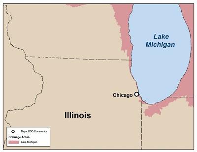
Illinois
There are 116 communities in Illinois with CSOs. All 41 CSO permits in the Great Lakes Basin in Illinois are in the Chicago metropolitan area and part of the TARP. The Metropolitan Water Reclamation District of Greater Chicago provides information on CSO discharges from the TARP system and has developed a program where reaches of the Chicagoland waterway map Exit will be color coded based on CSO data compiled by staff. The geographical boundaries of the segments are listed in the District's CSO Notification Plan Exit.
 The following Illinois permits are in the Great Lakes Basin:
| Municipal Operator of CSO | NPDES Permit Number | Great Lake Discharged To | Water Body Directly Discharged Into |
|---|---|---|---|
| Brookfield CSO TARP | ILM580032 | Lake Michigan | Salt Creek |
| Chicago CSO TARP | N/A | Lake Michigan | Chicago CSO - North Shore Channel, North Branch Chicago River, Little Calumet River, Calumet River, Chicago River, South Branch of Chicago River (SBCR), South Fork of SBCR, Chicago Sanitary and Ship Canal, Collateral Channel and Des Plaines River |
| City of Blue Island CSO TARP | ILM580031 | Lake Michigan | Cal-Sag Channel |
| City of Calumet City CSO TARP | ILM580025 | Lake Michigan | Little Calumet River |
| City of Evanston CSO TARP | ILM580002 | Lake Michigan | North Shore Channel |
| City of Harvey TARP | ILM580020 | Lake Michigan | Little Calumet River |
| Des Plaines TARP | ILM580026 | Lake Michigan | Des Plaines River |
| Dixmoor CSO TARP | ILM580011 | Lake Michigan | Little Calumet River |
| Franklin Park CSO TARP | ILM580029 | Lake Michigan | Des Plaines River |
| Golf CSO TARP | IL0072389 | Lake Michigan | North Branch Chicago River |
| LaGrange Park CSO TARP | ILM580008 | Lake Michigan | Salt Creek |
| Lansing CSO TARP | ILM580027 | Lake Michigan | Little Calumet River |
| Lincolnwood CSO TARP | ILM580034 | Lake Michigan | North Shore Channel |
| MWRDGC Calumet TARP | IL0028061 | Lake Michigan | Little Calumet River |
| MWRDGC Kirie TARP | IL0047741 | Lake Michigan | Weller's Creek |
| MWRDGC Stickney TARP | IL0028053 | Lake Michigan | Chicago Sanitary and Ship Canal |
| MWRDGC Northside TARP | IL0028088 | Lake Michigan | North Shore Channel |
| Park Ridge CSO TARP | ILM580014 | Lake Michigan | Des Plaines River |
| Phoenix CSO TARP | IL0072834 | Lake Michigan | Little Calumet River |
| Posen CSO TARP | ILM580037 | Lake Michigan | Cal-Sag Channel |
| Riverside CSO TARP | ILM580015 | Lake Michigan | Des Plaines River |
| Skokie CSO TARP | ILM580036 | Lake Michigan | North Shore Channel |
| Summit CSO TARP | ILM580033 | Lake Michigan | Chicago Sanitary and Ship Canal |
| Village of Arlington Heights CSO TARP | ILM580006 | Lake Michigan | Weller's Creek |
| Village of Burnham CSO TARP | ILM580018 | Lake Michigan | Grand Calumet River |
| Village of Calumet Park CSO TARP | ILM580016 | Lake Michigan | Cal-Sag Channel |
| Village of Dolton CSO TARP | ILM580017 | Lake Michigan | Little Calumet River |
| Village of Forest Park CSO TARP | ILM580019 | Lake Michigan | Des Plaines River |
| Village of LaGrange CSO TARP | ILM580009 | Lake Michigan | Salt Creek |
| Village of Lyons CSO TARP | ILM580004 | Lake Michigan | Des Plaines River |
| Village of Maywood CSO TARP | ILM580022 | Lake Michigan | Des Plaines River |
| Village of Melrose Park CSO TARP | ILM580003 | Lake Michigan | Des Plaines River |
| Village of Morton Grove CSO TARP | ILM580005 | Lake Michigan | North Branch Chicago River |
| Village of Niles CSO TARP | ILM580035 | Lake Michigan | North Branch Chicago River |
| Village of North Riverside TARP | ILM580030 | Lake Michigan | Des Plaines River |
| Village of River Forest CSO TARP | ILM580024 | Lake Michigan | Des Plaines River |
| Village of River Grove CSO TARP | ILM580021 | Lake Michigan | Des Plaines River |
| Village of Riverdale CSO TARP | ILM580013 | Lake Michigan | Little Calumet River |
| Village of Schiller CSO TARP | ILM580010 | Lake Michigan | Des Plaines River |
| Village of South Holland CSO TARP | ILM580023 | Lake Michigan | Little Calumet River |
| Village of Stickney CSO TARP | ILM580007 | Lake Michigan | Chicago Sanitary and Ship Canal |
Appendix A of the Report to Congress: Combined Sewer Overflows into the Great Lakes Basin has information on CSOs in communities in the Great Lakes Basin during 2014.
EPA’s Enforcement and Compliance History Online (ECHO) database has additional information on NPDES discharges, including CSO discharges for some facilites.
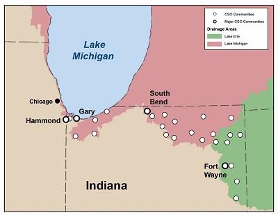
Indiana
There are 94 communities in Indiana with CSOs. The following 30 Indiana permits are in the Great Lakes Basin:
| Municipal Operator of CSO | NPDES Permit Number | Great Lake Discharged To | Water Body Directly Discharged Into |
|---|---|---|---|
| Albion | IN0022144 | Lake Michigan | None |
| Angola | IN0021296 | Lake Michigan | UNT Pigeon Creek |
| Auburn | IN0020672 | Lake Erie | Cedar Creek |
| Avilla | IN0020664 | Lake Erie | None |
| Berne | IN0021369 | Lake Erie | Habegger Ditch, Spruger Ditch |
| Bremen WWTP | IN0020427 | Lake Michigan | Yellow River |
| Butler | IN0022462 | Lake Erie | Big Run |
| Chesterton | IN0022578 | Lake Michigan | East Arm Little Calument River |
| Crown Point | IN0025763 | Lake Michigan | Main Beaver Dam Ditch |
| Decatur | IN0039314 | Lake Erie | St. Mary’s River |
| East Chicago | IN0022829 | Lake Michigan | Indiana Harbor Canal, Grand Calument River |
| Elkhart | IN0025674 | Lake Michigan | Elkhart River, St. Joseph River, Christina Creek |
| Fort Wayne | IN0032191 | Lake Erie | Maumee River, St. Mary's River, Spy Run Creek, St. Joseph River, UNT |
| Gary | IN0022977 | Lake Michigan | Grand Calumet River, Little Calumet River |
| Goshen | IN0025755 | Lake Michigan | Elkhart River |
| Hammond | IN0023060 | Lake Michigan | Grand Calumet River, East Arm Little Calumet River |
| Kendallville | IN0020656 | Lake Michigan | UNT Henderson Lake |
| Lagrange | IN0020478 | Lake Michigan | None |
| LaPorte Municipal STP | IN0025577 | Lake Michigan | Travis Ditch |
| Ligonier | IN0023582 | Lake Michigan | Elkhart River |
| Lowell Municipal STP | IN0023621 | Lake Michigan | Cedar Creek |
| Michigan City | IN0023752 | Lake Michigan | Trail Creek |
| Milford | IN0038318 | Lake Michigan | None |
| Mishawaka | IN0025640 | Lake Michigan | St. Joseph River, Eller Ditch |
| Nappanee | IN0021466 | Lake Michigan | Berlin Court Ditch, Armey Ditch |
| New Haven (Satellite Community) | IN0020346 | Lake Erie | Martin Ditch, UNT Maumee River |
| South Bend | IN0024520 | Lake Michigan | St. Joseph River |
| Valparaiso | IN0024660 | Lake Michigan | Salt Creek |
| Wakarusa | IN0024775 | Lake Michigan | Werntz Ditch |
| Waterloo | IN0020711 | Lake Erie | Cedar Creek |
Appendix A of the Report to Congress: Combined Sewer Overflows into the Great Lakes Basin has information on CSOs in communities in the Great Lakes Basin during 2014.
EPA’s Enforcement and Compliance History Online (ECHO) database has additional information on NPDES discharges, including CSO discharges for some facilites.
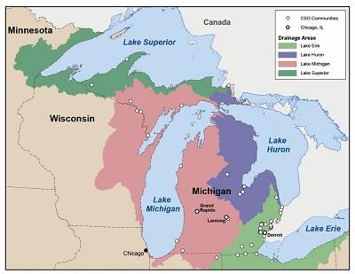
Michigan
The following 42 Michigan permits are in the Great Lakes Basin:
| Municipal Operator of CSO | NPDES Permit Number | Great Lake Discharged To | Water Body Directly Discharged Into |
|---|---|---|---|
| Adrian WWTP | MI0022152 | Lake Erie | South Branch Raisin River |
| Bay City WWTP | MI0022284 | Lake Huron | Saginaw River |
| Birmingham | MI0025534 | Lake Erie | Rouge River |
| Bloomfield Village CSO | MI0048046 | Lake Erie | Rouge River |
| Chapaton RTB | MI10025585 | Lake Erie | Chapaton Canal |
| Croswell WWTP | MI10021083 | Lake Erie | Black River |
| Dearborn CSO | MI0025542 | Lake Erie | Rouge River, Detroit River |
| Detroit WWTP | MI0022802 | Lake Erie | Rouge River, Detroit River |
| Dundee WWTP | MI0020401 | Lake Erie | Raisin River |
| East Lansing WWTP | MI0022853 | Lake Michigan | Red Cedar River |
| Essexville WWTP | MI0022918 | Lake Huron | Saginaw River |
| Gladwin WWTP | MI0023001 | Lake Huron | Cedar River |
| Grand Rapids WWTP | MI0026069 | Lake Michigan | Grand River |
| Inkster/Dearborn Heights CSO | MI0051837 | Lake Erie | Lower Rouge River |
| Iron Mountain Kingsford WWTP | MI0023205 | Lake Michigan | Menominee River |
| Lansing WWTP | MI0023400 | Lake Michigan | Grand River, Red Cedar River |
| Manistee WWTP | MI0020362 | Lake Michigan | Manistee Lake |
| Manistique WWTP | MI0023515 | Lake Michigan | Manistique River |
| Marysville WWTP | MI0020656 | Lake Erie | St. Clair River |
| Menominee WWTP | MI0025631 | Lake Michigan | Menominee River |
| Milk River CSO RTB | MI0025500 | Lake Erie | Milk River |
| Mt. Clemens WWTP | MI0023647 | Lake Erie | Clinton River |
| Niles WWTP | MI0023701 | Lake Michigan | St. Joseph River |
| North Houghton Co W&SA CSO | MI0043982 | Lake Superior | St. Louis Creek, Douglas Creek |
| Norway WWTP | MI0020214 | Lake Michigan | White Creek |
| Oakland Co-ACACIA Park CSO | MI0037427 | Lake Erie | Rouge River |
| Oakland Co-SOCSDS 12 Towns RTF (George W. Kuhn CSO RTB) | MI0026115 | Lake Erie | Red Run Drain |
| Port Huron WWTP | MI0023833 | Lake Erie | St. Clair River, Black River |
| Redford TWP CSO | MI0051829 | Lake Erie | Ashcroft-Sherwood Drain |
| River Rouge CSO | MI0028819 | Lake Erie | Rouge River |
| Saginaw TWP WWTP | MI0023973 | Lake Huron | Tittabawassee River |
| Saginaw WWTP | MI0025577 | Lake Huron | Saginaw River |
| Sault St. Marie WWTP | MI0024058 | Lake Huron | St. Marys River, Edison Power Canal |
| South Macomb SD Martin RTB | MI0025453 | Lake Erie | Lake St. Clair |
| Southgate/ Wyandotte CSO RTF |
MI0036072 | Lake Erie | Trenton Channel |
| St. Clair WWTP | MI0020591 | Lake Erie | St. Clair River |
| St. Joseph CSO | MI0026735 | Lake Michigan | St. Joseph River |
| Wakefield WWSL | MI0021440 | Lake Superior | Planter Creek |
| Wayne Co/Dearborn Heights CSO | MI0051489 | Lake Erie | Middle Rouge, Upper Rouge, Lower Rouge Rivers |
| Wayne Co/Inkster CSO | MI0051471 | Lake Erie | Lower Rouge River |
| Wayne Co/Inkster/ DRBRN HTS CSO |
MI0051462 | Lake Erie | Lower Rouge River |
| Wayne Co/RDFRD/ Livonia CSO |
MI0051535 | Lake Erie | Ashcroft-Sherwood Drain, Upper Rouge River, Bell Branch of Upper Rouge River |
The Michigan Department of Environmental Quality prepares annual reports Exit summarizing CSO, sanitary sewer overflow and retention basin discharge information.
Appendix A of the Report to Congress: Combined Sewer Overflows into the Great Lakes Basin has information on CSOs in communities in the Great Lakes Basin during 2014.
EPA’s Enforcement and Compliance History Online (ECHO) database has additional information on NPDES discharges, including CSO discharges for some facilites.
New York
There are 67 communities in New York with CSOs. The following 19 New York permits are in the Great Lakes Basin:
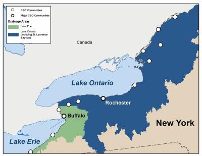
| Municipal Operator of CSO | NPDES Permit Number | Great Lake Discharged To | Water Body Directly Discharged Into |
|---|---|---|---|
| Auburn STP | NY0021903 | Lake Ontario | Owasco Outlet |
| Boonville WWTP | NY0020494 | Lake Ontario | Mill Creek |
| Buffalo Sewer Authority | NY0028410 | Lake Erie | Niagra River, Buffalo River, Scajaquada Creek, Black Rock Canal, Cazenovia Creek |
| Canastota WPCF | NY0029807 | Canastota Creek | |
| Clayton Village WTF | NY0027545 | St. Lawrence Seaway | St. Lawrence River |
| Dunkirk WWTP | NY0027961 | Lake Erie | Lake Erie |
| Frank E. VanLare STP (Rochester) | NY0028339 | Lake Ontario | Genesee River, Irondequoit Bay |
| Gouverneur STP | NY0020117 | St. Lawrence Seaway | Oswegatchie River |
| Lockport WWTP | NY0027057 | Lake Ontario | Barge Canal and Eighteenmile Creek |
| Massena WWTP | NY0031194 | St. Lawrence Seaway | St. Lawrence River |
| Medina WWTP | NY0021873 | Lake Ontario | Barge Canal and Oak Orchard Creek |
| North Tonawanda WWTP | NY0026280 | Lake Ontario | Niagara River |
| Niagara Falls WWTP | NY0026336 | Lake Ontario | Niagara River |
| Ogdensburg WWTP | NY0029831 | St. Lawrence Seaway | St. Lawrence River |
| City of Oswego, East Side STP | NY0029114 | Lake Ontario | Oswego River |
| Oswego-West Side STP | NY0029106 | Lake Ontario | Oswego River |
| Syracuse Metro WWTP | NY0027081 | Lake Ontario | Harbor Brook |
| Tupper Lake WPCP | NY0029939 | St. Lawrence Seaway | Raquette Pond |
| Watertown WPCP | NY0025984 | Lake Ontario | Black River |
Appendix A of the Report to Congress: Combined Sewer Overflows into the Great Lakes Basin has information on CSOs in communities in the Great Lakes Basin during 2014.
EPA’s Enforcement and Compliance History Online (ECHO) database has additional information on NPDES discharges, including CSO discharges for some facilites.
Ohio
There are 86 Communities in Ohio with CSOs. The following 55 Ohio communities are in the Great Lakes Basin:
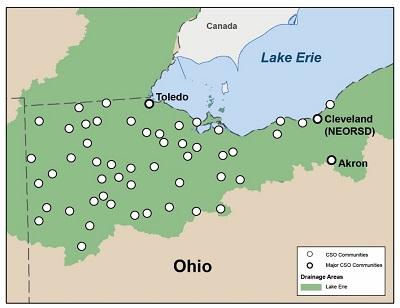
| Municipal Operator of CSO | NPDES Permit Number | Great Lake Discharged To | Water Body Directly Discharged Into |
|---|---|---|---|
| Akron | OH0023833 | Lake Erie | Cuyahoga River |
| Avon Lake | OH0023981 | Lake Erie | Lake Erie |
| Bluffton | OH0020851 | Lake Erie | Riley Creek |
| Bowling Green | OH0024139 | Lake Erie | Poe Ditch |
| Bucyrus | OH0052922 | Lake Erie | Sandusky River |
| Clyde | OH0024868 | Lake Erie | Raccoon Creek |
| Columbus Grove | OH0024759 | Lake Erie | Plum Creek |
| Crestline | OH0020664 | Lake Erie | Westerly Creek |
| Defiance | OH0024889 | Lake Erie | Maumee River |
| Delphos | OH0024929 | Lake Erie | Jennings Creek |
| Delta | OH0020974 | Lake Erie | Bad Creek |
| Deshler | OH0022471 | Lake Erie | Brush Creek |
| Dunkirk | OH0048321 | Lake Erie | Shallow Run Ditch |
| Elyria | OH0025003 | Lake Erie | Black River |
| Euclid | OH0031062 | Lake Erie | Lake Erie |
| Fayette | OH0025127 | Lake Erie | Unnamed stream to Deer Creek |
| Findlay | OH0025135 | Lake Erie | Blanchard River |
| Forest | OH0025151 | Lake Erie | Forest Simpson Ditch to Blanchard River |
| Fostoria | OH0052744 | Lake Erie | Portage River, East Branch |
| Fremont | OH0025291 | Lake Erie | Sandusky River |
| Gibsonburg | OH0029122 | Lake Erie | Hurlbut & SR 300 Ditch (to Portage River) |
| Green Springs | OH0022578 | Lake Erie | Flag Run Creek |
| Greenwich | OH0020486 | Lake Erie | SW Branch of Vermillion River |
| Hamler | OH0021105 | Lake Erie | South Turkey Foot Creek |
| Hicksville | OH0025771 | Lake Erie | Mill Creek |
| Lakewood | OH0026018 | Lake Erie | Lake Erie |
| Leipsic | OH0020826 | Lake Erie | Little Yellow Creek |
| Lima | OH0026069 | Lake Erie | Ottawa River |
| Luckey | OH0058971 | Lake Erie | Toussiant Creek |
| McComb | OH0026263 | Lake Erie | Algire Creek |
| Metamora | OH0058408 | Lake Erie | Ten Mile Creek |
| Monroeville | OH0020095 | Lake Erie | West Branch Huron River |
| Montpelier | OH0021831 | Lake Erie | St. Joseph River |
| Napoleon | OH0020893 | Lake Erie | Maumee River |
| NEOSRD | OH0043991 | Lake Erie | Lake Erie |
| North Baltimore | OH0020117 | Lake Erie | Rocky Ford Creek |
| Norwalk | OH0052604 | Lake Erie | Rattlesnake Creek |
| Oak Harbor | OH0026841 | Lake Erie | Portage River |
| Ohio City | OH0023396 | Lake Erie | Long Prairie Creek |
| Pandora | OH0021148 | Lake Erie | Riley Creek |
| Paulding | OH0020338 | Lake Erie | Flat Rock Creek |
| Payne | OH0021326 | Lake Erie | Flat Rock Creek |
| Perrysburg | OH0021008 | Lake Erie | Maumee River |
| Port Clinton | OH0052876 | Lake Erie | Portage River |
| Sandusky | OH0027332 | Lake Erie | Sandusky Bay |
| Swanton | OH0020524 | Lake Erie | Al Creek |
| Tiffin | OH0052949 | Lake Erie | Sandusky River |
| Toledo | OH0027740 | Lake Erie | Maumee River |
| Upper Sandusky | OH0020001 | Lake Erie | Sandusky River |
| VanWert | OH0027910 | Lake Erie | Town Creek |
| Wapakoneta | OH0027952 | Lake Erie | Auglaize River |
| Warren | OH0027987 | Lake Erie | Mahoning River |
| Wauseon | OH0023400 | Lake Erie | North Turkeyfoot Creek |
| Willard | OH0028118 | Lake Erie | Jacobs Creek |
| Woodville | OH0020591 | Lake Erie | Portage River |
View the Ohio Environmental Protection Agency's online interactive map Exit of CSO outfall locations and permit information.
The Ohio Environmental Protection Agency's website Exit has more information about the Ohio CSO Control Program.
Appendix A of the Report to Congress: Combined Sewer Overflows into the Great Lakes Basin has information on CSOs in communities in the Great Lakes Basin during 2014.
EPA’s Enforcement and Compliance History Online (ECHO) database has additional information on NPDES discharges, including CSO discharges for some facilites.
Pennsylvania
There are 144 communities in Pennsylvania with CSOs. Erie is the only Pennsylvania CSO community located in the Great Lakes Basin:
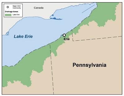
| Municipal Operator of CSO | NPDES Permit Number | Great Lake Discharged To | Water Body Directly Discharged Into |
|---|---|---|---|
| City of Erie | PA0026301 | Lake Erie | Lake Erie |
Appendix A of the Report to Congress: Combined Sewer Overflows into the Great Lakes Basin has information on CSOs in communities in the Great Lakes Basin during 2014.
EPA’s Enforcement and Compliance History Online (ECHO) database has additional information on NPDES discharges, including CSO discharges for some facilites.
Wisconsin
The following two Wisconsin communities are in the Great Lakes Basin:
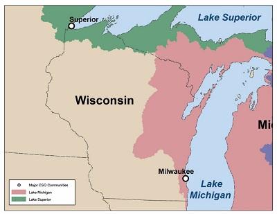
| Municipal Operator of CSO | NPDES Permit Number | Great Lake Discharged To | Water Body Directly Discharged Into |
|---|---|---|---|
| Milwaukee | WI0036820 | Lake Michigan | Lake Michigan |
| Superior | WI0025593 | Lake Superior | Lake Superior |
Appendix A of the Report to Congress: Combined Sewer Overflows into the Great Lakes Basin has information on CSOs in communities in the Great Lakes Basin during 2014.
EPA’s Enforcement and Compliance History Online (ECHO) database has additional information on NPDES discharges, including CSO discharges for some facilites.