Washington County Lead District - Furnace Creek Superfund Site, Washington County, Missouri - Fact Sheet, June 2016
EPA Conducting Remedial Investigation/Feasibility Study: Operable Units 1, 2, 3 and 4
INTRODUCTION
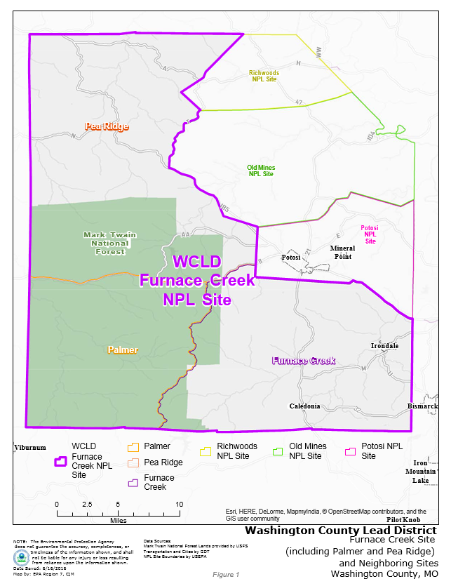 FIGURE 1On March 10, 2011, the U.S. Environmental Protection Agency (EPA) added the Furnace Creek Superfund Site to the National Priorities List (NPL). The NPL is a list of the nation’s hazardous waste sites with the highest priority for cleanup. These sites are eligible for extensive, long-term response action money, as authorized by Congress under the Superfund Program.
Furnace Creek was originally one of six sites located in Washington County (see Figure 1 at right). In the fall of 2012, the Pea Ridge and Palmer sites were incorporated into the Furnace Creek Superfund Site. The remaining three sites in Washington County – Potosi, Old Mines, and Richwood Superfund sites – are being addressed in separate investigations and are not included in the Furnace Creek Superfund Site.
Since May 2012, EPA Region 7 staff and contractors have been gathering environmental samples (soil, groundwater, mine waste, surface water, and sediment) to support the Remedial Investigation/Feasibility Study (RI/FS) at the Furnace Creek Superfund Site.
BACKGROUND
Washington County is part of Missouri’s Old Lead Belt, where mining occurred for several hundred years, due to the unique geology in Missouri. Mining activities in Washington County have contributed to elevated levels of lead in soil, groundwater, surface water, and sediment in the area. Some county residents have also unknowingly purchased lead-contaminated gravel for use in driveways, parking areas, and playgrounds.
Elevated lead levels in the environment can pose a threat to public health, especially for children 7 years old and younger and pregnant women. (For additional information, EPA contacts are listed at the end of this document.)
PREVIOUS SITE ACTIONS
Removal Investigation Phase
EPA previously conducted a site inspection and removal action at the Furnace Creek Site (prior to it qualifying for long-term funding under the NPL). In addition to the original Furnace Creek Site, EPA conducted site inspections and removal actions in the Palmer and Pea Ridge areas in 2012 and 2013.
During these efforts, EPA collected soil samples from more than 2,180 residential properties, and water samples from more than 1,700 drinking water wells within the site boundaries. Reports for these actions can be found at the site repositories listed at the end of this document.
Of the more than 2,180 properties where soil samples were collected, more than 510 had lead levels greater than the health-based standard. These properties were divided into two categories:
Of the more than 1,700 drinking water wells tested, 30 were confirmed to have lead levels in the groundwater that exceeded the agency’s maximum contaminant level (MCL) for lead (in water) of 15 micrograms/liter (mg/l).
Removal Action Phase
EPA’s initial response at this site focused on cleaning up the properties with the highest levels of lead in them, due to a potentially greater health risk. EPA cleaned up residential soil for more than 160 properties during the removal actions in the Furnace Creek, Palmer and Pea Ridge areas. The cleanup consisted of excavating and removing contaminated soil and gravel from affected properties and replacing the excavated material with clean fill and hydroseed.
EPA has also continued to offer and provide an alternate source of drinking water to interested property owners with impacted groundwater that exceeds the MCL of 15 mg/l.
REMEDIAL INVESTIGATION (RI) AND FEASIBILITY STUDY (FS)
EPA’s focus for the RI is on the properties assessed in the previous action that had lead levels between 400 ppm and 1,200 ppm (identified as Category No. 2, above). During the RI, EPA will continue to gather samples to determine the nature and extent of contamination at each property, establish cleanup criteria, identify remedial action objectives, and evaluate the technical cost factors that support these objectives. As a part of this process, EPA will conduct a feasibility study (FS). This study will evaluate different alternatives for cleaning up the site and provide recommendations for cleanup costs. Prior to any site decisions, EPA will present the findings of this process to the community and solicit comments about the next steps toward site cleanup.
During this process, EPA will continue to address newly-identified properties with lead levels greater than 1,200 ppm. EPA will also continue to address contamination in private drinking water supply wells by providing an alternate source of drinking water where lead or cadmium has been identified above health-based levels of concern.
After completion of the RI/FS, EPA will submit a proposed plan to the public for review, present agency findings in a public forum, provide an opportunity for the public to submit comments, and compile comments into a formal EPA document known as a Record of Decision (ROD). The ROD will identify the cleanup objectives that will be used to evaluate how the remaining properties will be addressed.
EPA is committed to providing communication between citizens and the agency. Active public involvement is crucial to the success of any public project. EPA will continue to engage the public in various community involvement activities designed to inform and involve community members throughout the decision-making process.
TECHNICAL ASSISTANCE GRANT
In an effort to help affected communities understand the technical information related to a Superfund site, EPA has established a Technical Assistance Grant (TAG) Program. The program provides up to $50,000 for a qualified citizens’ group to hire an independent technical advisor. The advisor can assist citizens in their interpretation of technical data, site hazards, and the different scientific technologies used to support site actions. (For persons specifically interested in the TAG Program, please see the additional information section below.)
ADMINISTRATIVE RECORD
During this phase of the Superfund process, EPA will compile the site administrative file. The administrative record file serves as the official record for the site and contains all site documents. This file is available for review, during normal business hours, at the following locations:
ADDITIONAL INFORMATION
If you have questions about this Fact Sheet or need additional information about the site, please contact: