About ICLUS
What is ICLUS?
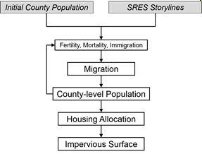 Figure: Overview of the ICLUS modeling process
Climate and land-use change are major drivers of global environmental change. Impact assessments frequently demonstrate that interactions between climate and land-use change may create serious challenges for aquatic ecosystems, water quality, and air quality. In many cases, it is impossible to assess the impact of climate change without consideration of land-use dynamics.
The Integrated Climate and Land-Use Scenarios (ICLUS) project produced spatially explicit projections of population and land-use that are based on the Intergovernmental Panel on Climate Change’s (IPCC) Special Report on Emissions Scenarios (SRES).
First, social, economic, and demographic storylines from the SRES were adapted for the United States. These modified storylines were then used to create population projections that would reflect different assumptions about fertility, mortality, and immigration through the end of this century.
Next, a mathematical model was used to simulate the migration of people within the United States. Then these county-level population projections are used to calculate the demand for new houses, which are placed across the U.S. landscape. Finally, we use a statistical model to estimate the amount of impervious surface that results from this new residential development.
A geospatial toolset is provided to create and process these high-resolution spatial data, and all of the outputs are available.
Below is a list of important milestones to the ICLUS project.
Below is a list of related publications to the ICLUS project.
-
Climate Change-Related Temperature Impacts on Warm Season Heat Mortality: A Proof-of-Concept Methodology Using BenMAP. 2011. Environmental Science & Technology 45(4): 1450-1457. DOI: 10.1021/es102820y. Exit
-
Intergovernmental Panel on Climate Change’s Special Report on Emissions Scenarios (SRES)
-
National housing and impervious surface scenarios for integrated climate impact assessments. 2010. Proceedings of the National Academy of Sciences 107(49): 20887-20892.Exit
-
Urban adaptation can roll back warming of emerging megapolitan regions. 2014. Proceedings of the National Academy of Sciences 111(8): 2909-2914. Exit
-
Variation in estimated ozone-related health impacts of climate change due to modeling choices and assumptions. 2011. Environmental Health Perspectives 120(1): 1559-1564.Exit