Coastal Resiliency
 Coastal areas are particularly vulnerable to the effects of climate change. Sea-level rise and heavy storms can result in erosion and flooding of these sensitive areas as well as loss of natural habitat.
During the 20th century, global sea level rose by roughly 7 inches. Global temperatures are expected to continue to climb, resulting in:
- sea levels continuing to rise,
- Storm surges being amplified, and
- heavy storms occurring with greater frequency and intensity.
These changes are expected to continue to erode the shoreline and damage property and infrastructure, potentially resulting in population displacement. This animation from the National Oceanic and Atmospheric Administration (NOAA) shows how storms impact coasts and how green infrastructure can help.
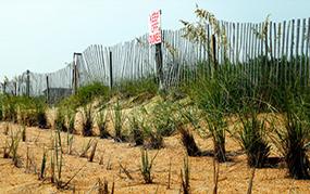
A green infrastructure approach to coastal improvement—a "living shoreline"—can be created using plants, reefs, sand, and natural barriers to reduce erosion and flooding. It also can lessen the associated impacts on human health and property. Restoring affected wetlands can reduce wave heights and property damage. In contrast to hard structures such as bulkheads and sea walls, vegetative shorelines provide multiple ecosystem benefits, including improved water quality, aquatic habitat, and carbon sequestration.
On this page:
This page contains technical information and references for state and local government officials working in the field of stormwater management.
How To
Living shorelines can be a mixture of structural and organic materials, including:
- native wetland plants,
- stone and rock structures,
- oyster reefs,
- submerged aquatic vegetation,
- coir fiber logs, and
- sand fill.
These practices can restore coastal shorelines to a more natural condition. Green infrastructure also can be used in combination with gray infrastructure, such as sea walls and jetties.
Launch your coastal improvement project using living shorelines by hosting a meeting to begin the process of establishing your site-specific needs. Include leaders in your state or regional area who are concerned with the environmental needs of your community.
Once you have established your site-specific needs, conduct a site assessment. This process should include determining the:
- type of shoreline (slope of bank),
- rate at which the shoreline is eroding,
- forces that are eroding the shoreline, and
- water depth, type of substrate, and salinity of the water body.
Resources
NOAA Office of Coastal Management —Programs and resources from the National Oceanic and Atmospheric Administration for protecting and enhancing coastal resources.
Sea Grant Climate Adaptation Resources Exit—A list of adaptation resources on the website of Pennsylvania Sea Grant, a partnership between Penn State University, the Commonwealth of Pennsylvania, and the National Oceanic and Atmospheric Administration.
Ecosystem-Based Management (EBM) Tools Network Exit—The EBM Tools Network is an alliance of EBM tool users, providers, and researchers that promotes the use and development of EBM in coastal and marine environments and watersheds that affect them. The network hosts the EBM Tools Database, which enables users to find, share, and contribute information about decision-support tools; projects and resources for innovative, interdisciplinary coastal-marine spatial planning; and EBM.
Georgetown Climate Center’s Adaptation Clearinghouse Exit—The clearinghouse serves as a resource to all states, assisting state policymakers, resource managers, academics, and others working to help communities adapt to climate change.
Adaptation Database and Planning Tool Exit (ADAPT)—ICLEI's tool to guide local government users through the Five Milestones for Climate Adaptation planning. It is available as part of ICLEI’s Climate Resilient Communities Program.
Coastal Resilience Program Exit—The Nature Conservancy's program provides information to communities, planners, businesses, and policy makers to help them address sea-level rise and coastal hazards in their decision-making.
Digital Coast Exit—A website sponsored by the National Oceans and Atmopheric Administration (NOAA) in collaboration with organizations committed to providing data and information, tools, and training resources to help address timely coastal issues (e.g., land use, coastal conservation, hazards, marine spatial planning).
Adaptation Tool Kit: Sea-Level Rise and Coastal Land Use Exit—This page on the Adaptation Clearinghouse website describes the tool kit, which explores 18 different land-use tools for responding to threats posed by sea-level rise to both public and private coastal development and infrastructure. The toolkit also provides policymakers with a framework for decision making.
References
EPA’s Climate Change in Coastal Communities Resources.
Leatherman, S. P., K. Zhang, and B. C. Douglas. 2000. Sea-level rise shown to drive coastal erosion. Eos, Tranactions, American Geophysical Union 81(6):55–57 Exit.
Swann, L. 2008. The Use of Living Shorelines to Mitigate the Effects of Storm Events on Dauphin Island, Alabama, USA (PDF). (12 pp, 1.2 K, About PDF) Exit Retrieved July 1, 2014.
Gedan, K.B., M. L. Kirwan, E. Wolanski, E.B. Barbier, and B. R. Silliman. 2011. The present and future role of coastal wetland vegetation in protecting shorelines: Answering recent challenges to the paradigm. Climatic Change 106:7-29.