About Lower Green Bay/Fox River AOC
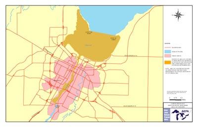 Green Bay Fox River AOC Boundary MapThe Lower Green Bay and Fox River Area of Concern consists of the lower 7 miles of the Fox River below DePere Dam and a 34 square mile area of southern Green Bay out to Point au Sable and Long Tail Point. The drainage area encompasses portions upper Fox River, Wolf River and the Fox River Basins, including the largest inland lake in Wisconsin, Lake Winnebago and its pool lakes.
While water quality problems and public use restrictions are most severe in the AOC, water resources in the entire basin are affected by runoff pollution from urban and rural areas, municipal and industrial wastewater discharges and degraded habitats. Industrialization was a major factor in Lower Green Bay/Fox River becoming contaminated.
Land water use upstream (logging, agriculture and industry) was a significant contributor to the numerous negative impacts to water quality in the water system. High turbidity, sedimentation, fluctuating dissolved oxygen, frequent algal blooms, degraded fish/wildlife/plant populations and adverse toxicant impacts have all been found in Lower Green Bay/Fox River. PCBs are the primary contaminant. The AOC is a shallow environment that has a rapid recycling system which also contributes to water quality issues.
- Restrictions on fish and wildlife consumption
- Tainting of fish and wildlife flavor
- Degradation of fish and wildlife populations
- Fish tumors or other deformities
- Degradation of aesthetics
- Degradation of benthos
- Restriction on dredging activities
- Loss of fish and wildlife habitat
- Bird or animal deformities or reproductive problems
- Eutrophication or undesirable algae
- Restrictions on drinking water consumption, or taste and odor
- Beach closings
- Degradation of phytoplankton and zooplankton populations