Lake Huron
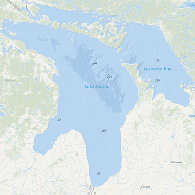 Lake Huron is the third largest of the lakes by volume with 3,540 km3 (850 cubic miles) of water. Its average depth is 59 meters (195 feet) and its maximum depth is 229 meters (750 feet). The Saginaw River basin is intensively farmed and contains the Flint and Saginaw-Bay City metropolitan areas. Saginaw Bay, like Green Bay, contains a very productive fishery. Geophysical Lake Huron
- Lake Huron Lakewide Action and Management Plans (LAMPs)
- Lake Huron LAMP Annual Reports
- Lake Huron Areas of Concern
Lahe Huron Lakewide Action and Management Plans (LAMPs)
Under the Great Lakes Water Quality Agreement (GLWQA), the governments of Canada and the United States have committed to restore and maintain the physical, biological and chemical integrity of the waters of the Great Lakes.
The Lakewide Action and Management Plans (LAMPs) are binational action plans for restoring and protecting the Great Lakes ecosystem.
The Binational Partnership facilitates information sharing, sets priorities, and coordinates binational environmental protection and restoration activities.
Lake Huron LAMP Annual Reports
The LAMP Annual Reports highlight accomplishments and progress in achieving LAMP goals during the past year and identifies LAMP-related activities including outreach, monitoring, and protection and restoration actions.
The following links exit the site Exit
- Lake Huron LAMP Annual Report 2015
- Lake Huron Binational Partnership Annual Report 2014
- Lake Huron Binational Partnership Annual Report 2013
- Lake Huron Binational Partnership Annual Report 2012