Housatonic River 1½ Mile of the GE-Pittsfield/Housatonic River Site
Overview of the Housatonic River 1½ Mile
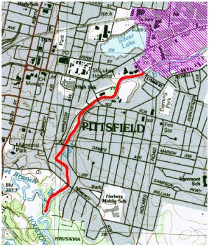 Map showing the EE/CA Reach and the general vicinity, including the location of the GE facilityThe 1½ Mile Reach represents a section of the East Branch of the Housatonic River between Lyman Street Bridge and the confluence of the East and West Branches of the Housatonic River. The 1½ Mile Reach is located within residential, commercial, industrial and undeveloped/recreational properties. There are approximately 40 residential properties located adjacent to the Housatonic River or within the floodplain. In the 1940s, approximately 1,500 feet of this reach was re-channelized by the City of Pittsfield and the United States Army Corps of Engineers. During the re-channelization efforts, three oxbows located within the first1,500-foot stretch of the 1.5 Mile Reach were filled in. In the first mile of the 1.5 mile reach, the riverbanks are generally steep and the floodplain is narrow. In the last half mile, the riverbanks are relatively low, resulting in a broad floodplain. Figure 1 shows the 1½ Mile Reach and its proximity to the GE facility.
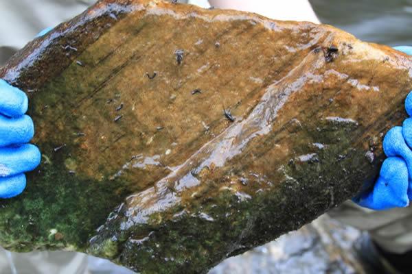
The average concentration of PCBs in the surficial sediments (0 to1 foot depth) was 21 parts per million (ppm) and the average concentration of PCBs in sediments at all depths was 29 ppm. For the riverbanks, the average concentration of PCBs in the top foot was approximately 23 ppm and the average concentration of PCBs in the top three feet was 40 ppm.
The Consent Decree required EPA to implement the removal action, with General Electric (GE) reimbursing EPA as part of a cost-sharing arrangement. As an example of how the cost-sharing agreement works, if the selected cleanup alternative costs a total of $85 million, GE will pay about $50 million and EPA will pay about $35 million (see the Consent Decree language under "Cleanup Agreements" for more details). EPA's selected remedy for the 1½ Mile Reach is described in a November 2000 "Action Memorandum" (PDF) (173 pp, 9.8 MB, About PDF).
In September 2002, immediately following GE's completion of the Upper ½-Mile Reach remediation, EPA initiated remediation activities in the 1½ Mile Reach. EPA completed excavation activities in March of 2006. Restoration activities, including restoration of support areas, were substantially completed by the end of 2006.
EPA performed the 1½ Mile removal action using two "dry excavation" techniques. The first technique used was similar to the method employed by GE in the Upper ½-Mile Reach. This is the sheetpile coffer dam technique, which consisted of using sheetpile to construct individual sheetpile cells along the river. To build a cell, a sheetpile wall was installed along the centerline of the riverbed, followed by an installation of upstream and downstream sheetpile cut-off walls, which branched off the centerline sheetpile wall and extended up the riverbank. The river flow is thus diverted around the sheetpile cell, the cell is then dewatered, and the sediment and riverbank soil is removed. The cell is then backfilled with clean fill and riprap to the design grade. Next, the two cut-off walls were removed and re-installed on the opposite side of the river, thus creating the next cell to be remediated and restored. Remediation activities then proceeded downstream, with the activities alternating from one side of the river to the other. Standard excavating equipment was used to complete the sediment and soil removal and backfilling. A typical sheetpile cell was approximately 300 feet long and approximately 30 feet wide.
This method was implemented at the beginning of the 1 1/2 mile Reach (Lyman Street Bridge) and continued to be used approximately 1,400 feet downstream.
The second "dry excavation" technique involved the use of a gravity-fed bypass system. The bypass system consisted of a temporary river diversion dam, which was installed approximately 1,400 feet downstream from the Lyman Street Bridge, and was used to divert the river flow into two 54-inch movable High Density Polyethylene (HDPE) pipes. The pipes were placed along one side of the river channel and the riverbed sediment and riverbank soil on the other side were removed and backfilled. The sediment and soil removal and backfilling was done by using standard excavation equipment. The pipes were then moved to the remediated side of the river and the process was repeated. Additional sections of pipe were added to the two 54-inch pipes extending the system as the removal and restoration progressed downstream. The gravity bypass system was used to remediate and restore approximately 3,400 feet of the river channel to a location 400 feet downstream of the Dawes Avenue Bridge. The gravity bypass technique was used in this area because shallow bedrock prevented the use of the sheetpile coffer dam system.
The remediation method then reverted back to the sheetpile coffer dam technique for the remaining 2,800 feet of the river to the confluence of the east and west branches of the Housatonic River.
In total, approximately 91,700 cubic yards (CY) of contaminated sediment and riverbank material was removed and disposed of as part of the 1.5 Mile Reach Removal Action. Approximately 7,000 CY of this material was impacted by non-aqueous phase liquids (NAPL). 50,750 CY of the contaminated material was disposed of at the GE's On-Plant Consolidation Areas and the remainder of the contaminated material, including all of the NAPL-impacted material, was disposed of at licensed off-site disposal facilities.
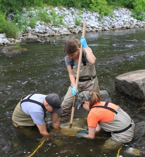
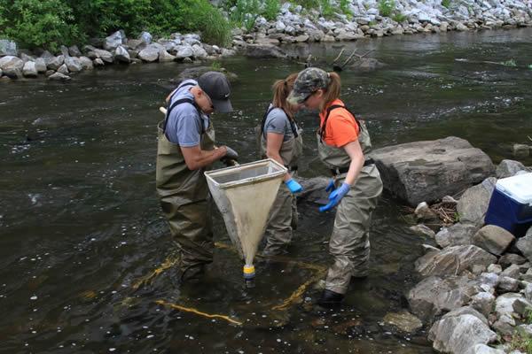
In 2007, EPA continued with minor restoration and maintenance activities. In addition, EPA conducted two post-remediation sampling programs. The first program consisted of the collection of 95 post-remediation surficial sediment samples. The results indicated an average surficial PCB concentration of 0.17 ppm; a greater than 99% reduction of PCBs compared to the pre-remediation surficial PCB concentrations. See the following link for a copy of the August 2007 Post-Remediation Sediment Sampling Report (PDF) (32 pp, 27.3 MB, About PDF) The second sampling program is described in the June 2007 Aquatic Invertebrate and Fish Sampling Work Plan (PDF) (12 pp, 1.6 MB, About PDF). The final report for Aquatic Invertebrate and Fish sampling, titled the Post-Remediation Aquatic Community Assessment Report is available at the following link: December 2007 Post-Remediation Aquatic Community Assessment Report (PDF) (28 pp, 477 K, About PDF).
In 2008, EPA finalized an Interim Post-Removal Site Control (PRSC) Plan. In early 2008, GE assumed responsibility for performing the post-removal site control activities (e.g., inspections, monitoring and maintenance activities) pursuant to the Interim PRSC Plan.
EPA issued the Final 1½ Mile Reach Completion Report and a Final Post-Removal Site Control Plan in 2011. GE is currently performing all required Post-Removal Site Control Activities, including inspection, monitoring and maintenance activities.
The cost of the 1½ Mile Reach cleanup, excluding indirect overhead-type costs and post-removal site control costs, is estimated at $84,000,000.
Reports for the Housatonic River 1½ Mile
- 1.5 Mile Reach Public Presentations
- 1.5 Mile Reach Annual Monitoring Reports
- 1.5 Mile Reach Post-Removal Inspection Reports
- 1.5 Mile Reach Post-Removal Sampling/Work Plans and Reports
- 1.5 Mile Reach Final Completion Report and Associated Documentation
- 1.5 Mile Reach Monthly Reports
- 1.5 Mile Reach Phase 3 Design Information
- 1.5 Mile Reach Phase 2 Design Information
- 1.5 Mile Reach Phase 1 / Phase 2 Transition Design Information
- 1.5 Mile Reach Phase 1 Design Information
- 1.5 Mile Reach Action Memorandum and Pre-Action Memo Reports/Documentation
")
")
")
")


")
")