WhAEM2000 BBM Files - Kansas
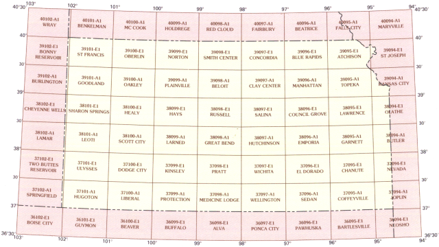
To find binary base map data for a specific geographic area, click on the appropriate 30 by 60 minute quadrangle on the state map below. A Web page containing a graphic of the 30 by 60 minute quadrangle will display eight subdivided 15 by 15 minute quadrangles. Alternatively, you can choose from an alphabetical text list of available 30 by 60 minute quadrangles.

| Atchison | Beloit | Blue Rapids | Bonny Reservoir | Burlington | Butler | Chanute | Cheyenne Wells | Clay Center | Coffeyville | Concordia | Council | Dodge City | El Dorado | Emporia | Garnett | Goodland | Great Bend | Hays | Healy | Hugoton | Hutchins | Joplin | Kansas City | Kinsley | Lamar | Larned | Lawrence | Leoti | Liberal | Manhattan | Medicine | Nevada | Norton | Oakley | Oberlin | Olathe | Plainville | Pratt | Protection | Russell | Saint Francis | Saint Joseph | Salina | Scott City | Sedan | Sharon Springs | Smith Center | Springfield | Topeka | Two Buttes Reservoir | Ulysses | Wellington | Wichita |
