About Detroit River AOC
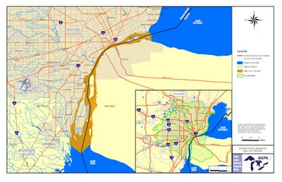 Detroit River AOC Boundary Map The Detroit River is a 32-mile international connecting channel linking Lake St. Clair and the upper Great Lakes to Lake Erie. The Detroit River Area of Concern is a binational AOC in which 75 percent of the total land area of the watershed is in Michigan. It was named an Area of Concern on the Great Lakes under the Great Lakes Water Quality Agreement of 1987.
The area was considered highly degraded because of:
- Urban and industrial development
- Combined sewer overflows
- Municipal and industrial discharges
- Stormwater runoff and tributaries
These sources of pollution have contributed to high levels of:
- bacteria
- PCBs
- polycyclic aromatic hydrocarbons (PAHs)
- metals
- oils and greases
The Detroit River AOC is part of a binational system of tributaries, including other AOCs.
Beneficial Use Impairments
- Tainting of fish and wildlife flavor – REMOVED 2013
- Restrictions on drinking water consumption, or taste and odor – REMOVED 2011
- Restrictions on fish and wildlife consumption
- Degradation of fish and wildlife populations
- Beach closings
- Fish tumors or other deformities
- Degradation of aesthetics
- Bird or animal deformities or reproduction problems
- Degradation of benthos
- Restriction on dredging activities
- Loss of fish and wildlife habitat