About the Columbia River: Bonneville Dam to the Pacific Ocean

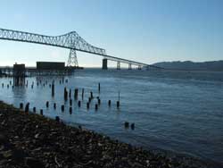
The lower portion of the Columbia River stretches 146 miles from Bonneville Dam - the last of 14 dams on the river - to the Pacific Ocean. Another large tributary, the Willamette River, joins the Columbia downstream from Bonneville. When the Columbia finally meets the ocean more than 1,200 miles from its source in the Canadian Rockies, it flows in with such force that it spills a plume of freshwater four miles out into the ocean, creating an estuary of vital importance to people and wildlife.
Below are summaries of key EPA projects in the lower portion of the Columbia River basin.
Portland Harbor Superfund Site
The Portland Harbor Superfund site in Portland, Oregon, is the result of more than a century of industrial use along the Willamette River. Sediment is contaminated with many hazardous substances, including heavy metals, polychlorinated biphenyls (PCBs), polynuclear aromatic hydrocarbons (PAH), dioxin, and pesticides. The cleanup investigation currently extends from lower Willamette River, approximately between the Broadway Bridge in downtown Portland and Sauvie Island. People work along the river and also use it for recreational activities such as fishing, boating, and swimming.
Although we work and recreate along Portland Harbor, the primary way people are exposed to contamination there is by eating fish such as bass, catfish and carp. These fish, called resident fish, carry levels of chemical contaminants which may cause cancer or developmental problems. PCBs are the primary contaminant associated with most of the risk from eating resident fish. Young children, nursing infants and babies in the womb are the most sensitive to the chemicals. Mothers and children should avoid eating bass, catfish and carp caught in Portland Harbor.
Learn more about EPA's Portland Harbor cleanup and how to get involved, request Superfund training, and receive updates and invitations to community information sessions.
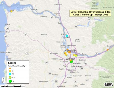
Cleanup Progress in the Lower Columbia Click map for larger view of cleanup acreage in the lower Columbia River basin.
Since 2006, 89 acres of contaminated sediments in the Lower Columbia River have been cleaned up as a result of state and federal actions. These 89 acres are among 400 acres of known contaminated sites in the Columbia River Basin.
Key cleanup sites include:
- Ross Island, Portland (near mile 15 of the Willamette River)
- Johnson Lake, Portland (south of the Columbia Slough)
- Zidell, Portland
- ALCOA aluminum smelter, Vancouver, Washington, and
- Smaller sites along the Columbia Slough
The cleanups in these areas provide a significant contribution to reducing toxics in the Columbia River.
Lower Columbia River Estuary Partnership
The Lower Columbia Estuary Partnership was established in 1995 and is one of 28 programs in EPA's National Estuary Program (NEP) that protects and restores an estuary of national significance. Its mission is to improve the lower Columbia River by protecting and restoring ecosystems and enhancing clean water for current and future generations of fish, wildlife, and people. It is a collaborative program led by farmers, educators, businesses and economic interests, conservation groups, citizens, state governments, federal agencies, and tribal governments. The Estuary Partnership restores and protects habitat, improves water quality, advances science, and provides information about the river to a range of audiences. The Estuary Partnership is a 501(c)3 non-profit corporation that works along the lower 146 miles of the Columbia River from Bonneville Dam to the Pacific Ocean.
